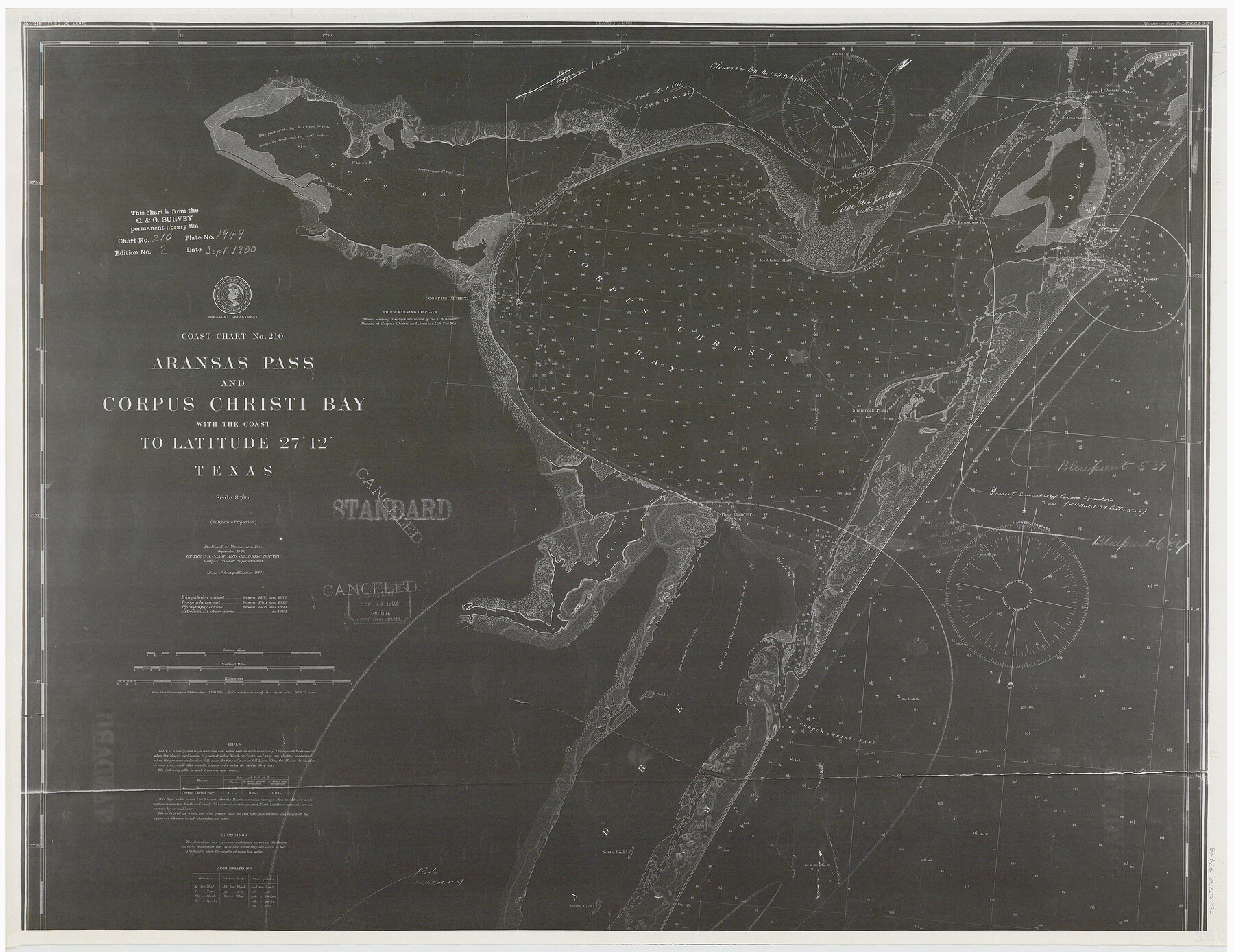
Coast Chart No. 210 - Aransas Pass and Corpus Christi Bay with the coast to latitude 27° 12', Texas
K-2-210a1
-
Map/Doc
73448
-
Collection
General Map Collection
-
Object Dates
1900 (Creation Date)
-
Counties
Aransas San Patricio Nueces Kleberg
-
Subjects
Nautical Charts
-
Height x Width
18.3 x 23.6 inches
46.5 x 59.9 cm
Part of: General Map Collection
Randall County Working Sketch 2

Print $20.00
- Digital $50.00
Randall County Working Sketch 2
1980
Size 28.6 x 31.3 inches
Map/Doc 71839
Flight Mission No. DQN-1K, Frame 47, Calhoun County

Print $20.00
- Digital $50.00
Flight Mission No. DQN-1K, Frame 47, Calhoun County
1953
Size 18.4 x 22.6 inches
Map/Doc 84147
Pecos County Rolled Sketch 54

Print $11.00
- Digital $50.00
Pecos County Rolled Sketch 54
1916
Size 9.7 x 15.0 inches
Map/Doc 48099
Kimble County Working Sketch 7

Print $20.00
- Digital $50.00
Kimble County Working Sketch 7
1917
Size 12.6 x 16.8 inches
Map/Doc 70075
Kinney County Rolled Sketch 15

Print $20.00
- Digital $50.00
Kinney County Rolled Sketch 15
Size 28.2 x 43.4 inches
Map/Doc 9354
Jasper County Working Sketch 29

Print $20.00
- Digital $50.00
Jasper County Working Sketch 29
1956
Size 20.6 x 31.4 inches
Map/Doc 66491
Harris County Sketch File 109

Print $16.00
- Digital $50.00
Harris County Sketch File 109
2003
Size 11.1 x 8.7 inches
Map/Doc 78506
Travis County Sketch File 2

Print $4.00
- Digital $50.00
Travis County Sketch File 2
1851
Size 8.2 x 9.9 inches
Map/Doc 38271
Armstrong County Working Sketch 9

Print $20.00
- Digital $50.00
Armstrong County Working Sketch 9
1993
Size 40.9 x 33.6 inches
Map/Doc 67240
El Paso County Rolled Sketch 52

Print $20.00
- Digital $50.00
El Paso County Rolled Sketch 52
1929
Size 18.5 x 24.3 inches
Map/Doc 5849
Pecos County Sketch File 96

Print $40.00
- Digital $50.00
Pecos County Sketch File 96
1957
Size 22.4 x 8.7 inches
Map/Doc 33998
Pecos County Working Sketch 132

Print $40.00
- Digital $50.00
Pecos County Working Sketch 132
1979
Size 34.6 x 49.3 inches
Map/Doc 71606
You may also like
Terrell County Working Sketch 32

Print $20.00
- Digital $50.00
Terrell County Working Sketch 32
1945
Size 33.0 x 36.9 inches
Map/Doc 62124
Levelland Independent School District Hockley County, Texas

Print $20.00
- Digital $50.00
Levelland Independent School District Hockley County, Texas
Size 36.2 x 29.8 inches
Map/Doc 92240
General Highway Map, Bell County, Texas

Print $20.00
General Highway Map, Bell County, Texas
1961
Size 18.3 x 25.1 inches
Map/Doc 79366
Glasscock County Sketch File 24

Print $4.00
- Digital $50.00
Glasscock County Sketch File 24
1948
Size 15.5 x 9.1 inches
Map/Doc 24204
Jeff Davis County Working Sketch 33

Print $40.00
- Digital $50.00
Jeff Davis County Working Sketch 33
1977
Size 28.8 x 48.3 inches
Map/Doc 66528
Karnes County Sketch File 11

Print $4.00
- Digital $50.00
Karnes County Sketch File 11
1885
Size 10.5 x 8.1 inches
Map/Doc 28602
Jefferson County Rolled Sketch 12

Print $2.00
- Digital $50.00
Jefferson County Rolled Sketch 12
Size 12.2 x 7.1 inches
Map/Doc 9279
Liberty County Working Sketch 76

Print $20.00
- Digital $50.00
Liberty County Working Sketch 76
1980
Size 13.7 x 18.5 inches
Map/Doc 70536
Uvalde County Working Sketch 21

Print $20.00
- Digital $50.00
Uvalde County Working Sketch 21
1949
Size 21.2 x 18.2 inches
Map/Doc 72091
Travis County Rolled Sketch 32A

Print $40.00
- Digital $50.00
Travis County Rolled Sketch 32A
Size 57.6 x 37.3 inches
Map/Doc 10013
Zavala County Sketch File 2

Print $22.00
- Digital $50.00
Zavala County Sketch File 2
Size 13.2 x 14.4 inches
Map/Doc 41261
A New Map of the Whole Continent of America. Divided into North and South and West Indies, wherein are exactly decribed the United States of North America as well as the Several European Possessions according to the Preliminaries of Peace…

Print $40.00
- Digital $50.00
A New Map of the Whole Continent of America. Divided into North and South and West Indies, wherein are exactly decribed the United States of North America as well as the Several European Possessions according to the Preliminaries of Peace…
Size 22.0 x 48.3 inches
Map/Doc 95135