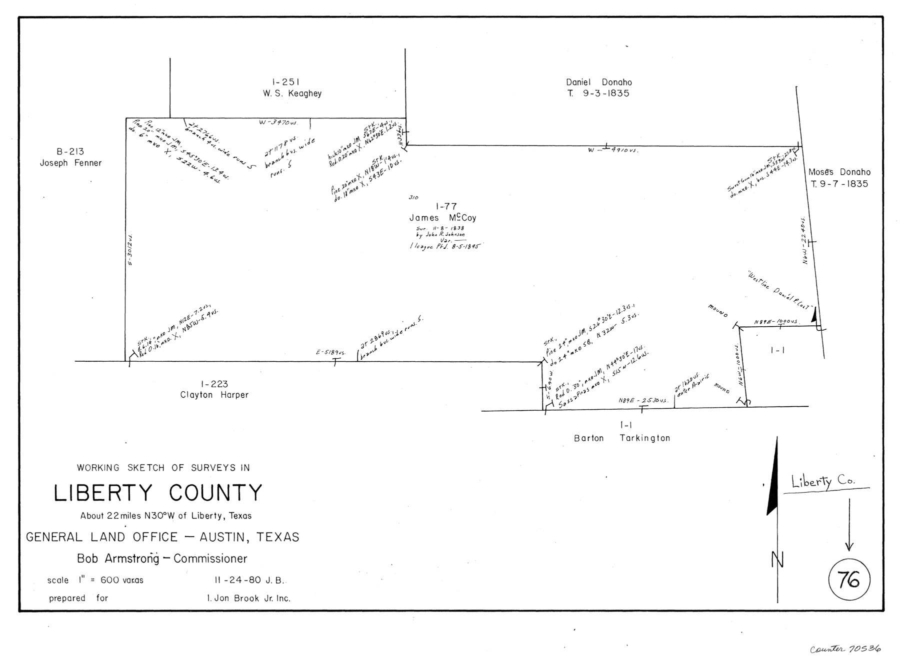
Liberty County Working Sketch 76
-
Map/Doc
70536
-
Collection
General Map Collection
-
Object Dates
11/24/1980 (Creation Date)
-
People and Organizations
Jana Brod ()
-
Counties
Liberty
-
Subjects
Surveying Working Sketch
-
Height x Width
13.7 x 18.5 inches
34.8 x 47.0 cm
-
Scale
1" = 600 varas
Part of: General Map Collection

Hudspeth County Working Sketch 15

Print $20.00
- Digital $50.00
Hudspeth County Working Sketch 15
1954
Size 36.4 x 16.2 inches
Map/Doc 66297
Flight Mission No. CRE-2R, Frame 170, Jackson County

Print $20.00
- Digital $50.00
Flight Mission No. CRE-2R, Frame 170, Jackson County
1956
Size 18.6 x 22.1 inches
Map/Doc 85380
Brazoria County Sketch File 29

Print $8.00
- Digital $50.00
Brazoria County Sketch File 29
1889
Size 14.0 x 8.8 inches
Map/Doc 15033
Brewster County Sketch File 57

Print $6.00
- Digital $50.00
Brewster County Sketch File 57
2008
Size 11.0 x 8.5 inches
Map/Doc 88871
Palo Pinto County Sketch File 27

Print $21.00
- Digital $50.00
Palo Pinto County Sketch File 27
1875
Size 9.8 x 15.7 inches
Map/Doc 33430
Presidio County Working Sketch 105

Print $20.00
- Digital $50.00
Presidio County Working Sketch 105
1980
Size 27.5 x 27.5 inches
Map/Doc 71782
Trinity River, South Dallas Sheet

Print $20.00
- Digital $50.00
Trinity River, South Dallas Sheet
1917
Size 28.8 x 21.4 inches
Map/Doc 69684
Frio County Working Sketch 24

Print $20.00
- Digital $50.00
Frio County Working Sketch 24
1992
Size 47.0 x 35.2 inches
Map/Doc 69298
Map of the City of Corsicana (Navarro County) Texas

Print $40.00
- Digital $50.00
Map of the City of Corsicana (Navarro County) Texas
1963
Size 36.7 x 87.5 inches
Map/Doc 93675
Harris County Sketch File 55

Print $20.00
- Digital $50.00
Harris County Sketch File 55
1916
Size 21.8 x 29.7 inches
Map/Doc 11655
Harbor of Brazos Santiago, Texas

Print $20.00
- Digital $50.00
Harbor of Brazos Santiago, Texas
1887
Size 27.1 x 18.3 inches
Map/Doc 72995
You may also like
Harris County

Print $40.00
- Digital $50.00
Harris County
1896
Size 44.4 x 69.3 inches
Map/Doc 66857
Upton County Rolled Sketch 33

Print $20.00
- Digital $50.00
Upton County Rolled Sketch 33
1951
Size 39.2 x 33.0 inches
Map/Doc 8076
El Paso County Boundary File 18

Print $21.00
- Digital $50.00
El Paso County Boundary File 18
Size 13.7 x 8.5 inches
Map/Doc 53196
Zavala County Working Sketch 23

Print $40.00
- Digital $50.00
Zavala County Working Sketch 23
1980
Size 77.3 x 43.6 inches
Map/Doc 62098
Milam County Working Sketch 4

Print $20.00
- Digital $50.00
Milam County Working Sketch 4
1954
Size 26.1 x 32.4 inches
Map/Doc 71019
Webb County Sketch File 10-1

Print $20.00
- Digital $50.00
Webb County Sketch File 10-1
1850
Size 14.8 x 15.5 inches
Map/Doc 12625
Ward County Rolled Sketch 22

Print $40.00
- Digital $50.00
Ward County Rolled Sketch 22
1873
Size 69.2 x 18.0 inches
Map/Doc 10110
Outer Continental Shelf Leasing Maps (Texas Offshore Operations)

Print $20.00
- Digital $50.00
Outer Continental Shelf Leasing Maps (Texas Offshore Operations)
Size 13.5 x 14.2 inches
Map/Doc 75843
Borden County, Texas

Print $20.00
- Digital $50.00
Borden County, Texas
1887
Size 19.9 x 18.3 inches
Map/Doc 596
Uvalde County

Print $20.00
- Digital $50.00
Uvalde County
1976
Size 43.0 x 46.3 inches
Map/Doc 95660
Eastland County Sketch File 22

Print $33.00
- Digital $50.00
Eastland County Sketch File 22
1964
Size 11.0 x 17.0 inches
Map/Doc 21626
Montague County Working Sketch 29

Print $20.00
- Digital $50.00
Montague County Working Sketch 29
1972
Size 27.8 x 22.1 inches
Map/Doc 71095