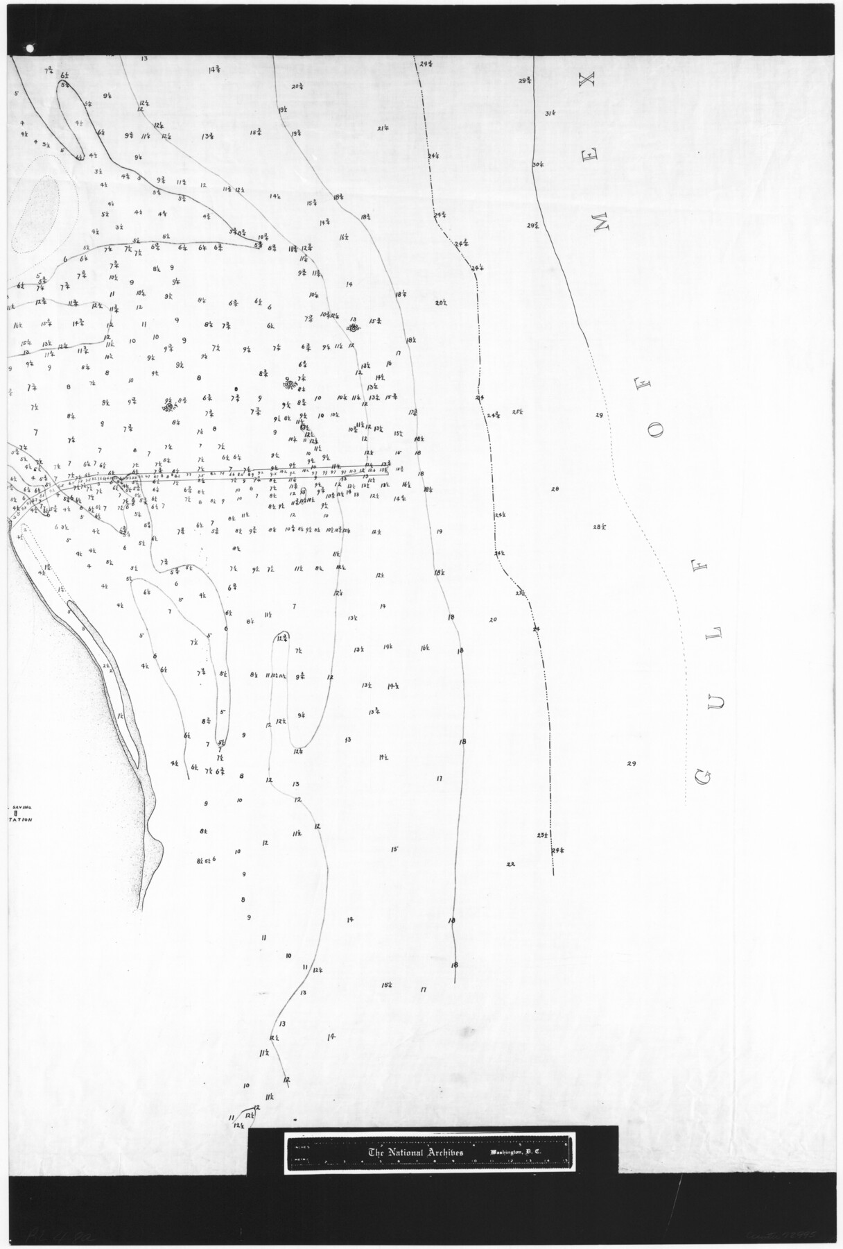
Harbor of Brazos Santiago, Texas
RL-4-8a
-
Map/Doc
72995
-
Collection
General Map Collection
-
Object Dates
1887 (Creation Date)
-
People and Organizations
Corps of Engineers, U. S. Army (Publisher)
Corps of Engineers (Author)
George A. Zinn (Surveyor/Engineer)
E.M. Hartrick (Surveyor/Engineer)
-
Subjects
Nautical Charts
-
Height x Width
27.1 x 18.3 inches
68.8 x 46.5 cm
-
Comments
B/W photostat copy from National Archives in multiple pieces.
Part of: General Map Collection
Map of Washburn, Armstrong County, Texas junction of Pan-Handle (Southern Kansas) and Fort Worth & Denver City R'ys

Print $20.00
- Digital $50.00
Map of Washburn, Armstrong County, Texas junction of Pan-Handle (Southern Kansas) and Fort Worth & Denver City R'ys
1888
Map/Doc 97426
Briscoe County Working Sketch 10

Print $20.00
- Digital $50.00
Briscoe County Working Sketch 10
1958
Size 30.0 x 24.2 inches
Map/Doc 67813
Matagorda County Rolled Sketch 38

Print $295.00
- Digital $50.00
Matagorda County Rolled Sketch 38
1984
Size 23.2 x 23.2 inches
Map/Doc 6697
Packery Channel

Print $2.00
- Digital $50.00
Packery Channel
1971
Size 9.2 x 9.1 inches
Map/Doc 2998
Crockett County Rolled Sketch 91

Print $40.00
- Digital $50.00
Crockett County Rolled Sketch 91
1928
Size 26.0 x 70.5 inches
Map/Doc 8737
Red River County Working Sketch 17

Print $20.00
- Digital $50.00
Red River County Working Sketch 17
1954
Size 23.2 x 18.8 inches
Map/Doc 72000
Chambers County Sketch File 53

Print $12.00
- Digital $50.00
Chambers County Sketch File 53
1952
Size 14.3 x 8.9 inches
Map/Doc 18087
Red River County Working Sketch 2

Print $20.00
- Digital $50.00
Red River County Working Sketch 2
1918
Size 26.9 x 21.7 inches
Map/Doc 71985
Bee County Sketch File 25

Print $4.00
- Digital $50.00
Bee County Sketch File 25
1880
Size 11.0 x 8.2 inches
Map/Doc 14326
San Jacinto County Sketch File 17

Print $40.00
San Jacinto County Sketch File 17
1934
Size 60.1 x 26.3 inches
Map/Doc 10598
Sulphur River, Bassett Sheet

Print $20.00
- Digital $50.00
Sulphur River, Bassett Sheet
1939
Size 23.9 x 31.5 inches
Map/Doc 69683
Flight Mission No. DAG-24K, Frame 45, Matagorda County

Print $20.00
- Digital $50.00
Flight Mission No. DAG-24K, Frame 45, Matagorda County
1953
Size 18.6 x 22.2 inches
Map/Doc 86532
You may also like
Flight Mission No. DCL-6C, Frame 53, Kenedy County

Print $20.00
- Digital $50.00
Flight Mission No. DCL-6C, Frame 53, Kenedy County
1943
Size 18.6 x 22.4 inches
Map/Doc 85895
Crosby County Working Sketch 12

Print $20.00
- Digital $50.00
Crosby County Working Sketch 12
1953
Size 26.0 x 29.8 inches
Map/Doc 68446
Leon County Rolled Sketch 29

Print $20.00
- Digital $50.00
Leon County Rolled Sketch 29
1992
Size 34.6 x 32.9 inches
Map/Doc 6612
Childress County Rolled Sketch 8

Print $20.00
- Digital $50.00
Childress County Rolled Sketch 8
1889
Size 12.4 x 22.2 inches
Map/Doc 5442
Flight Mission No. CGI-3N, Frame 127, Cameron County

Print $20.00
- Digital $50.00
Flight Mission No. CGI-3N, Frame 127, Cameron County
1954
Size 18.8 x 22.4 inches
Map/Doc 84600
Map of the Texas and Pacific Railway and connections

Print $20.00
- Digital $50.00
Map of the Texas and Pacific Railway and connections
1925
Size 8.2 x 9.3 inches
Map/Doc 95772
[Map of Uvalde County]
![4108, [Map of Uvalde County], General Map Collection](https://historictexasmaps.com/wmedia_w700/maps/4108.tif.jpg)
Print $20.00
- Digital $50.00
[Map of Uvalde County]
1862
Size 27.7 x 26.7 inches
Map/Doc 4108
Terrell County Working Sketch 45

Print $20.00
- Digital $50.00
Terrell County Working Sketch 45
1957
Size 21.5 x 37.2 inches
Map/Doc 62138
Hudspeth County Sketch File 47

Print $30.00
- Digital $50.00
Hudspeth County Sketch File 47
1978
Size 14.5 x 8.9 inches
Map/Doc 27050
Glasscock County

Print $20.00
- Digital $50.00
Glasscock County
1899
Size 44.2 x 35.5 inches
Map/Doc 4957
[Eastern Texas RR. Co. Block 1]
![91896, [Eastern Texas RR. Co. Block 1], Twichell Survey Records](https://historictexasmaps.com/wmedia_w700/maps/91896-1.tif.jpg)
Print $20.00
- Digital $50.00
[Eastern Texas RR. Co. Block 1]
Size 17.9 x 15.3 inches
Map/Doc 91896
San Augustine County

Print $20.00
- Digital $50.00
San Augustine County
1871
Size 20.7 x 14.2 inches
Map/Doc 4014