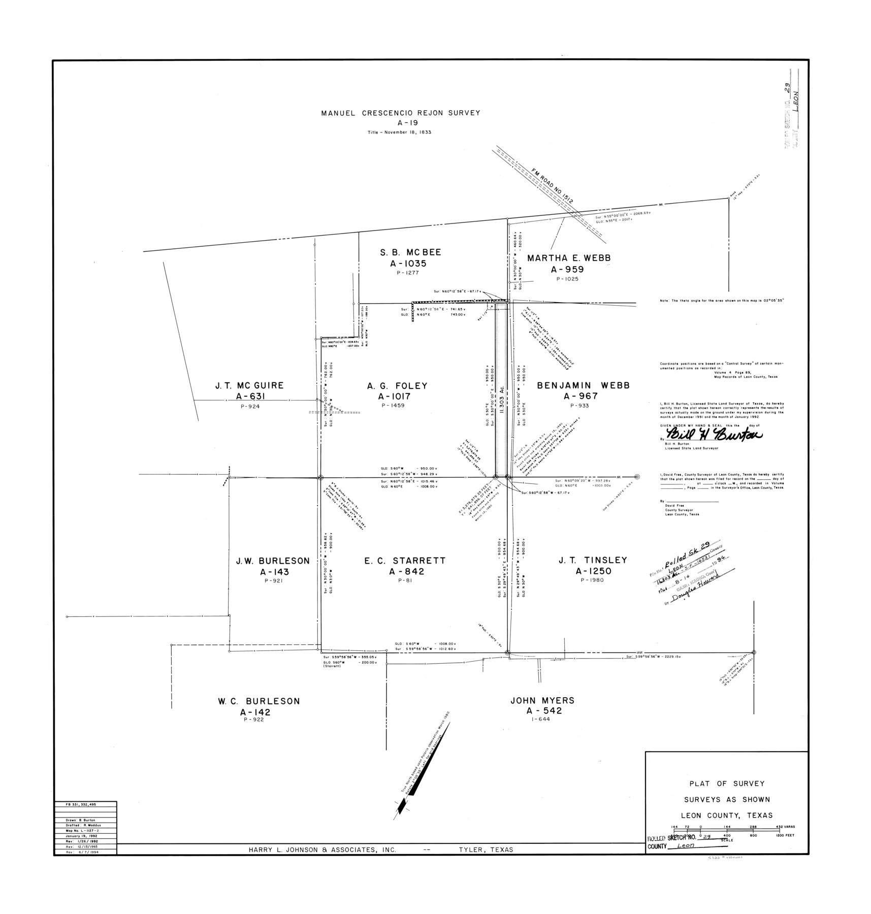
Leon County Rolled Sketch 29
[Plat of A.G. Foley and E.C. Starrett surveys]
-
Map/Doc
6612
-
Collection
General Map Collection
-
Object Dates
1992/1/19 (Creation Date)
1994/8/14 (File Date)
1992/1/26 (Revision Date)
1993/12/13 (Revision Date)
1994/6/7 (Revision Date)
-
People and Organizations
Bill H. Burton (Surveyor/Engineer)
R. Maddux (Draftsman)
-
Counties
Leon
-
Subjects
Surveying Rolled Sketch
-
Height x Width
34.6 x 32.9 inches
87.9 x 83.6 cm
-
Medium
mylar, print
Part of: General Map Collection
Kerr County Working Sketch 37

Print $20.00
- Digital $50.00
Kerr County Working Sketch 37
1995
Size 19.0 x 24.0 inches
Map/Doc 70068
Uvalde County Sketch File 9

Print $4.00
- Digital $50.00
Uvalde County Sketch File 9
Size 6.8 x 8.8 inches
Map/Doc 38967
Flight Mission No. CRC-1R, Frame 157, Chambers County

Print $20.00
- Digital $50.00
Flight Mission No. CRC-1R, Frame 157, Chambers County
1956
Size 18.8 x 22.5 inches
Map/Doc 84719
Brewster County Rolled Sketch 81

Print $20.00
- Digital $50.00
Brewster County Rolled Sketch 81
1945
Size 30.8 x 33.9 inches
Map/Doc 8494
Map of Burnet Co.

Print $20.00
- Digital $50.00
Map of Burnet Co.
1887
Size 45.5 x 37.9 inches
Map/Doc 7816
Martin County Rolled Sketch 8

Print $20.00
- Digital $50.00
Martin County Rolled Sketch 8
Size 28.8 x 20.9 inches
Map/Doc 6668
Tarrant County Working Sketch 24

Print $20.00
- Digital $50.00
Tarrant County Working Sketch 24
2003
Size 26.0 x 34.9 inches
Map/Doc 78642
Presidio County Rolled Sketch SM

Print $15.00
- Digital $50.00
Presidio County Rolled Sketch SM
1910
Size 9.5 x 15.0 inches
Map/Doc 48822
Montague County Working Sketch 34

Print $20.00
- Digital $50.00
Montague County Working Sketch 34
1979
Size 20.3 x 15.0 inches
Map/Doc 71100
Reeves County Working Sketch 21

Print $20.00
- Digital $50.00
Reeves County Working Sketch 21
1964
Size 32.7 x 27.0 inches
Map/Doc 63464
Potter County Sketch File 13

Print $20.00
- Digital $50.00
Potter County Sketch File 13
Size 21.6 x 16.6 inches
Map/Doc 12199
Chambers County Sketch File 29

Print $20.00
- Digital $50.00
Chambers County Sketch File 29
Size 29.0 x 34.5 inches
Map/Doc 10332
You may also like
Red River County Working Sketch Graphic Index, Sheet 2 (Sketches 49 to Most Recent)

Print $20.00
- Digital $50.00
Red River County Working Sketch Graphic Index, Sheet 2 (Sketches 49 to Most Recent)
1934
Size 46.4 x 39.1 inches
Map/Doc 76681
Shallow Water Country of Northwest Texas

Shallow Water Country of Northwest Texas
1916
Map/Doc 96758
Flight Mission No. CRC-3R, Frame 206, Chambers County

Print $20.00
- Digital $50.00
Flight Mission No. CRC-3R, Frame 206, Chambers County
1956
Size 18.5 x 22.2 inches
Map/Doc 84861
Atascosa County Working Sketch 7

Print $3.00
- Digital $50.00
Atascosa County Working Sketch 7
1913
Size 14.0 x 9.4 inches
Map/Doc 67203
Pecos County Working Sketch 139

Print $20.00
- Digital $50.00
Pecos County Working Sketch 139
1982
Size 31.1 x 24.9 inches
Map/Doc 71613
Post Route Map of the State of Texas with Adjacent Parts of Louisiana, Arkansas, Indian Territory and the Republic of Mexico Showing Post Offices with the Intermediate Distances and Mail Routes in Operation on the 1st of April 1891

Print $40.00
Post Route Map of the State of Texas with Adjacent Parts of Louisiana, Arkansas, Indian Territory and the Republic of Mexico Showing Post Offices with the Intermediate Distances and Mail Routes in Operation on the 1st of April 1891
1891
Size 44.5 x 58.2 inches
Map/Doc 89061
Flight Mission No. DQN-1K, Frame 65, Calhoun County

Print $20.00
- Digital $50.00
Flight Mission No. DQN-1K, Frame 65, Calhoun County
1953
Size 18.5 x 22.2 inches
Map/Doc 84152
Padre Island National Seashore, Texas - Dependent Resurvey

Print $4.00
- Digital $50.00
Padre Island National Seashore, Texas - Dependent Resurvey
2001
Size 18.4 x 24.0 inches
Map/Doc 60549
Flight Mission No. CRC-6R, Frame 39, Chambers County

Print $20.00
- Digital $50.00
Flight Mission No. CRC-6R, Frame 39, Chambers County
1956
Size 18.7 x 22.5 inches
Map/Doc 84972
Limestone County Working Sketch 25

Print $20.00
- Digital $50.00
Limestone County Working Sketch 25
1981
Size 26.1 x 21.1 inches
Map/Doc 70575
Clay County Sketch File 11

Print $4.00
- Digital $50.00
Clay County Sketch File 11
1870
Size 10.1 x 7.9 inches
Map/Doc 18408
Scurry County Working Sketch 10

Print $20.00
- Digital $50.00
Scurry County Working Sketch 10
1990
Size 25.7 x 28.7 inches
Map/Doc 63839