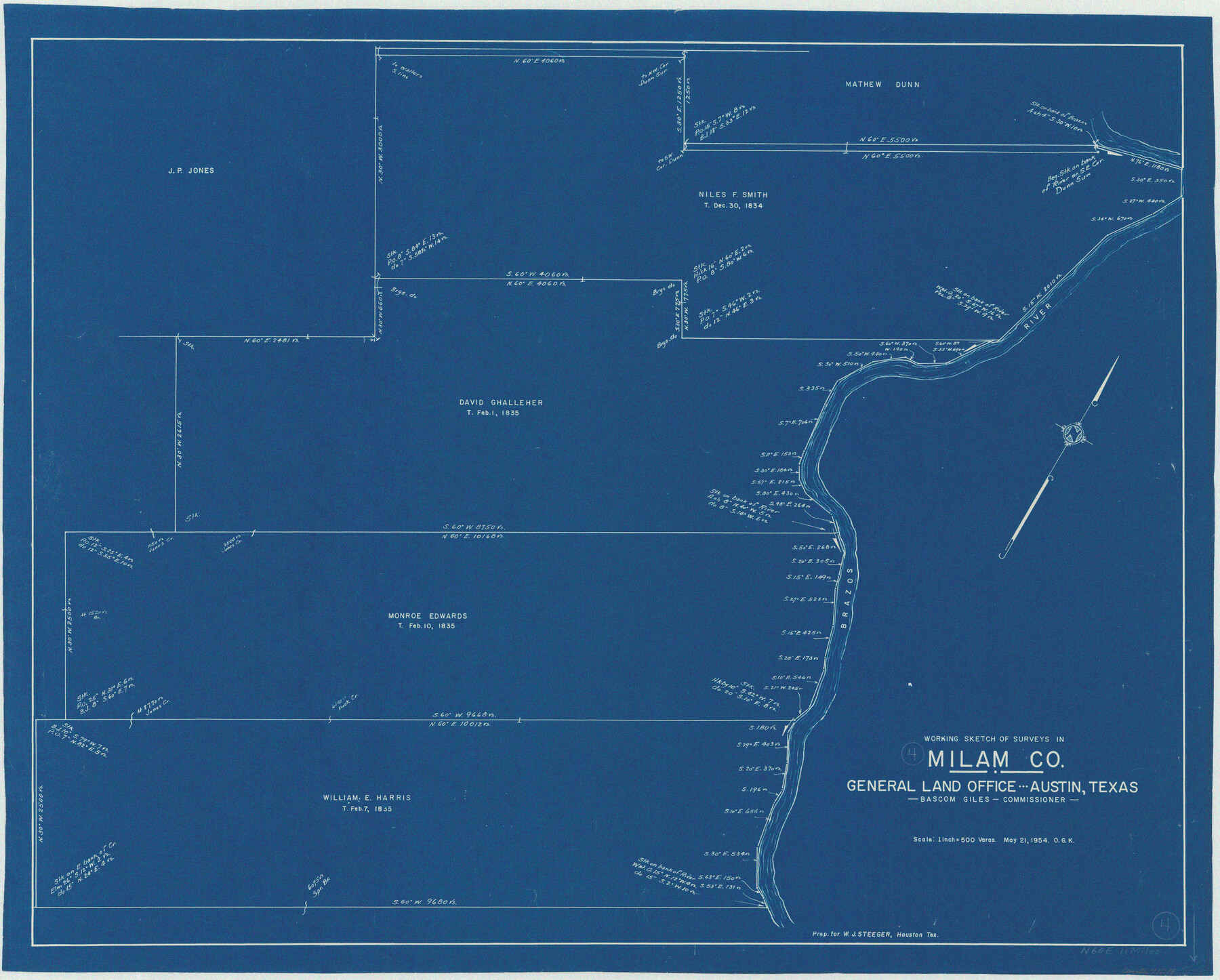
Milam County Working Sketch 4
-
Map/Doc
71019
-
Collection
General Map Collection
-
Object Dates
5/21/1954 (Creation Date)
-
People and Organizations
Otto G. Kurio (Draftsman)
-
Counties
Milam
-
Subjects
Surveying Working Sketch
-
Height x Width
26.1 x 32.4 inches
66.3 x 82.3 cm
-
Scale
1" = 500 varas
Part of: General Map Collection
Township 1 North Range 11 West, North Western District, Louisiana

Print $20.00
- Digital $50.00
Township 1 North Range 11 West, North Western District, Louisiana
1884
Size 19.6 x 24.7 inches
Map/Doc 65878
[Jose Pineda grant]
![123, [Jose Pineda grant], General Map Collection](https://historictexasmaps.com/wmedia_w700/maps/123.tif.jpg)
Print $2.00
- Digital $50.00
[Jose Pineda grant]
1846
Size 13.6 x 7.7 inches
Map/Doc 123
[Galveston, Harrisburg & San Antonio through El Paso County]
![64011, [Galveston, Harrisburg & San Antonio through El Paso County], General Map Collection](https://historictexasmaps.com/wmedia_w700/maps/64011.tif.jpg)
Print $20.00
- Digital $50.00
[Galveston, Harrisburg & San Antonio through El Paso County]
1906
Size 13.3 x 33.8 inches
Map/Doc 64011
Galveston County Rolled Sketch 37

Print $20.00
- Digital $50.00
Galveston County Rolled Sketch 37
Size 26.8 x 16.5 inches
Map/Doc 5971
Young County Sketch File 11

Print $4.00
- Digital $50.00
Young County Sketch File 11
1877
Size 10.1 x 8.5 inches
Map/Doc 40874
Brewster County Working Sketch 105

Print $40.00
- Digital $50.00
Brewster County Working Sketch 105
1980
Size 42.5 x 77.6 inches
Map/Doc 67705
Briscoe County

Print $20.00
- Digital $50.00
Briscoe County
1930
Size 46.2 x 39.2 inches
Map/Doc 1787
Newton County Working Sketch 4

Print $20.00
- Digital $50.00
Newton County Working Sketch 4
1924
Size 24.1 x 21.0 inches
Map/Doc 71250
Karnes County Rolled Sketch 1

Print $20.00
- Digital $50.00
Karnes County Rolled Sketch 1
1943
Size 27.5 x 25.7 inches
Map/Doc 6452
Kimble County

Print $40.00
- Digital $50.00
Kimble County
1890
Size 39.2 x 57.5 inches
Map/Doc 78435
[Map of the Fort Worth & Denver City Railway]
![64433, [Map of the Fort Worth & Denver City Railway], General Map Collection](https://historictexasmaps.com/wmedia_w700/maps/64433.tif.jpg)
Print $40.00
- Digital $50.00
[Map of the Fort Worth & Denver City Railway]
1887
Size 22.2 x 110.1 inches
Map/Doc 64433
Gillespie County Rolled Sketch 9

Print $20.00
- Digital $50.00
Gillespie County Rolled Sketch 9
2014
Size 23.6 x 36.2 inches
Map/Doc 93713
You may also like
Baylor County Sketch File A10

Print $8.00
- Digital $50.00
Baylor County Sketch File A10
1927
Size 11.3 x 8.9 inches
Map/Doc 14100
Gonzales County

Print $40.00
- Digital $50.00
Gonzales County
1986
Size 41.6 x 54.7 inches
Map/Doc 73160
Nueces County Rolled Sketch 73

Print $20.00
- Digital $50.00
Nueces County Rolled Sketch 73
1981
Size 24.2 x 36.0 inches
Map/Doc 6931
Travis County

Print $40.00
- Digital $50.00
Travis County
1936
Size 47.0 x 53.7 inches
Map/Doc 73305
Hamilton County Sketch File 6

Print $6.00
- Digital $50.00
Hamilton County Sketch File 6
Size 15.7 x 10.6 inches
Map/Doc 24910
Kenedy County Rolled Sketch 17

Print $40.00
- Digital $50.00
Kenedy County Rolled Sketch 17
1958
Size 96.6 x 28.5 inches
Map/Doc 10726
Flight Mission No. BRA-16M, Frame 120, Jefferson County

Print $20.00
- Digital $50.00
Flight Mission No. BRA-16M, Frame 120, Jefferson County
1953
Size 18.4 x 22.6 inches
Map/Doc 85730
Flight Mission No. DQN-1K, Frame 158, Calhoun County

Print $20.00
- Digital $50.00
Flight Mission No. DQN-1K, Frame 158, Calhoun County
1953
Size 18.6 x 22.3 inches
Map/Doc 84217
La Salle County Working Sketch 25

Print $20.00
- Digital $50.00
La Salle County Working Sketch 25
1947
Size 32.8 x 41.0 inches
Map/Doc 70326
Railroad and County Map of Texas

Print $20.00
- Digital $50.00
Railroad and County Map of Texas
1908
Size 42.7 x 44.7 inches
Map/Doc 2141
Stonewall County Sketch File B1

Print $20.00
- Digital $50.00
Stonewall County Sketch File B1
1901
Size 36.2 x 34.9 inches
Map/Doc 10379
Caldwell County Working Sketch Graphic Index

Print $20.00
- Digital $50.00
Caldwell County Working Sketch Graphic Index
1935
Size 36.7 x 41.3 inches
Map/Doc 76483