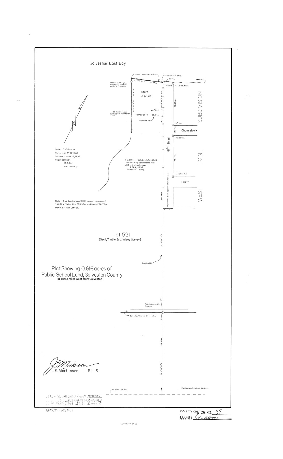
Galveston County Rolled Sketch 37
Plat showing 0.616 acres of Public School Land, Galveston County
-
Map/Doc
5971
-
Collection
General Map Collection
-
Object Dates
1983/6/23 (Survey Date)
1983/12/19 (File Date)
-
People and Organizations
James E. Mortensen (Surveyor/Engineer)
-
Counties
Galveston
-
Subjects
Surveying Rolled Sketch
-
Height x Width
26.8 x 16.5 inches
68.1 x 41.9 cm
-
Medium
mylar, print
-
Scale
1" = 30 varas
Part of: General Map Collection
Map of the Gainesville, Henrietta & Western Railway

Print $20.00
- Digital $50.00
Map of the Gainesville, Henrietta & Western Railway
1887
Size 9.6 x 41.7 inches
Map/Doc 64482
Montague County Boundary File 1

Print $32.00
- Digital $50.00
Montague County Boundary File 1
Size 12.8 x 8.1 inches
Map/Doc 57399
Baylor County Sketch File 23

Print $60.00
- Digital $50.00
Baylor County Sketch File 23
1927
Size 25.2 x 48.9 inches
Map/Doc 10324
Kinney County Working Sketch 23

Print $20.00
- Digital $50.00
Kinney County Working Sketch 23
1950
Size 20.8 x 24.3 inches
Map/Doc 70205
Runnels County Sketch File 27

Print $6.00
Runnels County Sketch File 27
1949
Size 11.5 x 8.9 inches
Map/Doc 35490
Andrews County Sketch File 10

Print $40.00
- Digital $50.00
Andrews County Sketch File 10
1950
Size 27.4 x 18.2 inches
Map/Doc 10810
Jefferson County Rolled Sketch 48

Print $20.00
- Digital $50.00
Jefferson County Rolled Sketch 48
1963
Size 28.3 x 34.8 inches
Map/Doc 6403
Webb County Boundary File 3a

Print $10.00
- Digital $50.00
Webb County Boundary File 3a
Size 14.2 x 8.7 inches
Map/Doc 59753
La Salle County Rolled Sketch 22

Print $20.00
- Digital $50.00
La Salle County Rolled Sketch 22
1955
Size 31.0 x 30.3 inches
Map/Doc 6585
Floyd County Rolled Sketch 11

Print $20.00
- Digital $50.00
Floyd County Rolled Sketch 11
2000
Size 15.5 x 20.9 inches
Map/Doc 5884
Flight Mission No. BQY-4M, Frame 115, Harris County

Print $20.00
- Digital $50.00
Flight Mission No. BQY-4M, Frame 115, Harris County
1953
Size 18.6 x 22.5 inches
Map/Doc 85282
Travis County Working Sketch 24

Print $20.00
- Digital $50.00
Travis County Working Sketch 24
1948
Size 25.6 x 23.1 inches
Map/Doc 69408
You may also like
Map of Hidalgo County

Print $20.00
- Digital $50.00
Map of Hidalgo County
1896
Size 44.9 x 25.5 inches
Map/Doc 4684

Montgomery County Working Sketch 2

Print $20.00
- Digital $50.00
Montgomery County Working Sketch 2
1914
Size 14.5 x 23.2 inches
Map/Doc 71108
Flight Mission No. BRA-17M, Frame 10, Jefferson County

Print $20.00
- Digital $50.00
Flight Mission No. BRA-17M, Frame 10, Jefferson County
1953
Size 18.5 x 22.2 inches
Map/Doc 85791
Harris County Working Sketch 62

Print $20.00
- Digital $50.00
Harris County Working Sketch 62
1954
Size 41.1 x 37.4 inches
Map/Doc 65954
[Leagues 218- 236]
![91454, [Leagues 218- 236], Twichell Survey Records](https://historictexasmaps.com/wmedia_w700/maps/91454-1.tif.jpg)
Print $2.00
- Digital $50.00
[Leagues 218- 236]
Size 7.0 x 11.6 inches
Map/Doc 91454
Texas City Channel, Texas, Channel and Turning Basin Dredging - Sheet 3

Print $20.00
- Digital $50.00
Texas City Channel, Texas, Channel and Turning Basin Dredging - Sheet 3
1958
Size 28.4 x 40.6 inches
Map/Doc 61833
Grayson County Sketch File 27

Print $122.00
- Digital $50.00
Grayson County Sketch File 27
1875
Size 12.8 x 8.0 inches
Map/Doc 24510
Central America Past and Present

Central America Past and Present
1986
Size 20.6 x 31.6 inches
Map/Doc 96839
Palo Pinto County Working Sketch 12

Print $20.00
- Digital $50.00
Palo Pinto County Working Sketch 12
1946
Size 21.1 x 33.7 inches
Map/Doc 71395
Thomas Ross Survey

Print $20.00
- Digital $50.00
Thomas Ross Survey
1954
Size 16.8 x 17.6 inches
Map/Doc 92181
Jasper County Sketch File 1a

Print $8.00
- Digital $50.00
Jasper County Sketch File 1a
1859
Size 12.1 x 7.7 inches
Map/Doc 27765