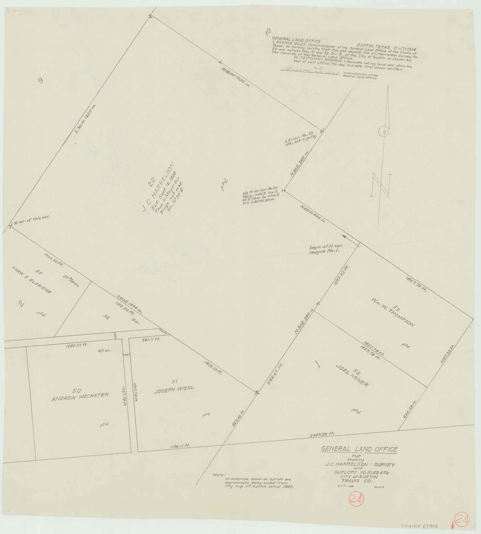
Travis County Working Sketch 24
Plat showing J.C. Harrelson Survey and Outlots 50, 51, 52, and 53 City of Austin
-
Map/Doc
69408
-
Collection
General Map Collection
-
Object Dates
2/17/1948 (Creation Date)
-
Counties
Travis
-
Subjects
Surveying Working Sketch
-
Height x Width
25.6 x 23.1 inches
65.0 x 58.7 cm
Part of: General Map Collection
Map of Uvalde County

Print $20.00
- Digital $50.00
Map of Uvalde County
1862
Size 27.4 x 20.7 inches
Map/Doc 4109
Schleicher County Sketch File 6

Print $4.00
- Digital $50.00
Schleicher County Sketch File 6
Size 8.1 x 8.5 inches
Map/Doc 36472
Tarrant County Sketch File 1a

Print $4.00
- Digital $50.00
Tarrant County Sketch File 1a
1851
Size 10.2 x 7.8 inches
Map/Doc 37670
State Tracts in East Part of Corpus Christi Bay, surveys on Harbor Island and Corpus Christi Channel, Nueces County

Print $40.00
- Digital $50.00
State Tracts in East Part of Corpus Christi Bay, surveys on Harbor Island and Corpus Christi Channel, Nueces County
1957
Size 54.1 x 37.7 inches
Map/Doc 1919
Hopkins County Sketch File 19

Print $4.00
- Digital $50.00
Hopkins County Sketch File 19
1870
Size 10.2 x 8.0 inches
Map/Doc 26723

Bandera County Working Sketch 6

Print $20.00
- Digital $50.00
Bandera County Working Sketch 6
1917
Size 14.2 x 14.3 inches
Map/Doc 67599
Map of Ellis Farm Unit, Texas Department of Corrections, Walker County, Texas

Print $20.00
- Digital $50.00
Map of Ellis Farm Unit, Texas Department of Corrections, Walker County, Texas
Size 36.3 x 27.1 inches
Map/Doc 2284

Jefferson County Rolled Sketch 64

Print $20.00
- Digital $50.00
Jefferson County Rolled Sketch 64
1982
Size 26.7 x 37.4 inches
Map/Doc 9319
Montgomery County Sketch File 24

Print $6.00
- Digital $50.00
Montgomery County Sketch File 24
Size 12.2 x 8.0 inches
Map/Doc 31867
Flight Mission No. DAG-23K, Frame 59, Matagorda County

Print $20.00
- Digital $50.00
Flight Mission No. DAG-23K, Frame 59, Matagorda County
1953
Size 18.5 x 22.3 inches
Map/Doc 86486
You may also like
Hopkins County Boundary File 2

Print $4.00
- Digital $50.00
Hopkins County Boundary File 2
Size 12.5 x 8.1 inches
Map/Doc 55057
Limestone County

Print $40.00
- Digital $50.00
Limestone County
1922
Size 50.6 x 36.2 inches
Map/Doc 73342
Presidio County Sketch File 70b

Print $6.00
- Digital $50.00
Presidio County Sketch File 70b
Size 11.2 x 8.9 inches
Map/Doc 34671
Travis County Working Sketch 53

Print $40.00
- Digital $50.00
Travis County Working Sketch 53
1964
Size 42.7 x 53.0 inches
Map/Doc 69437
Zavala County Rolled Sketch 27

Print $20.00
- Digital $50.00
Zavala County Rolled Sketch 27
1955
Size 21.2 x 20.0 inches
Map/Doc 8329
Flight Mission No. DCL-7C, Frame 61, Kenedy County

Print $20.00
- Digital $50.00
Flight Mission No. DCL-7C, Frame 61, Kenedy County
1943
Size 15.4 x 15.2 inches
Map/Doc 86049
Maverick County Sketch File 11

Print $40.00
- Digital $50.00
Maverick County Sketch File 11
1879
Size 8.3 x 8.8 inches
Map/Doc 31092
Laguna Madre, Register No. 1477A

Print $40.00
- Digital $50.00
Laguna Madre, Register No. 1477A
1880
Size 34.3 x 56.0 inches
Map/Doc 73606
Potter County Boundary File 3f

Print $4.00
- Digital $50.00
Potter County Boundary File 3f
Size 6.3 x 4.4 inches
Map/Doc 57995
Wichita County Sketch File 1

Print $22.00
- Digital $50.00
Wichita County Sketch File 1
1856
Size 13.5 x 16.8 inches
Map/Doc 40028
Hockley County Sketch File 14

Print $20.00
- Digital $50.00
Hockley County Sketch File 14
1911
Size 26.5 x 17.5 inches
Map/Doc 11773
Hunt County Working Sketch 11

Print $20.00
- Digital $50.00
Hunt County Working Sketch 11
2002
Size 32.1 x 29.6 inches
Map/Doc 66358