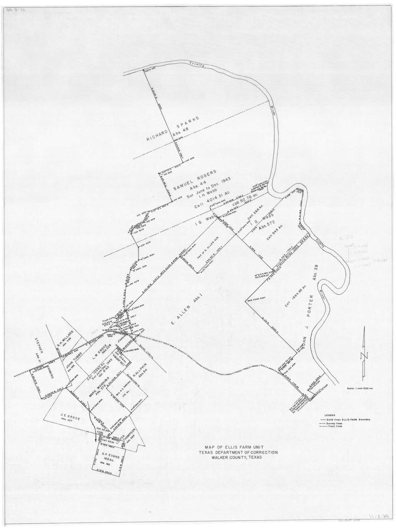
Map of Ellis Farm Unit, Texas Department of Corrections, Walker County, Texas
RG-2-11
-
Map/Doc
2284
-
Collection
General Map Collection
-
People and Organizations
Texas Department of Corrections (Author)
-
Counties
Walker
-
Height x Width
36.3 x 27.1 inches
92.2 x 68.8 cm
Part of: General Map Collection
San Patricio County Rolled Sketch 31

Print $20.00
- Digital $50.00
San Patricio County Rolled Sketch 31
1941
Size 43.1 x 42.6 inches
Map/Doc 9898
Hardeman County Working Sketch 9

Print $20.00
- Digital $50.00
Hardeman County Working Sketch 9
1953
Size 44.4 x 27.2 inches
Map/Doc 63390
Presidio County Sketch File 119

Print $14.00
- Digital $50.00
Presidio County Sketch File 119
1996
Size 14.3 x 9.0 inches
Map/Doc 34927
Flight Mission No. CRC-2R, Frame 191, Chambers County

Print $20.00
- Digital $50.00
Flight Mission No. CRC-2R, Frame 191, Chambers County
1956
Size 18.6 x 22.4 inches
Map/Doc 84769
Andrews County Rolled Sketch 43

Print $20.00
- Digital $50.00
Andrews County Rolled Sketch 43
Size 26.1 x 41.0 inches
Map/Doc 77183
Harris County Sketch File 78

Print $32.00
- Digital $50.00
Harris County Sketch File 78
1955
Size 8.7 x 9.0 inches
Map/Doc 25549
Walker County

Print $20.00
- Digital $50.00
Walker County
1944
Size 45.7 x 38.4 inches
Map/Doc 73314
Floyd County Working Sketch 2

Print $20.00
- Digital $50.00
Floyd County Working Sketch 2
1911
Size 41.0 x 24.8 inches
Map/Doc 69181
Mexicque, ou Nouvelle Espagne, Nouvelle Gallice, Iucatan & c. et autres Provinces jusques a L'Isthme de Panama; ou font les Audiences de Mexico, de Guadalaiara, et de Guatimala

Print $20.00
- Digital $50.00
Mexicque, ou Nouvelle Espagne, Nouvelle Gallice, Iucatan & c. et autres Provinces jusques a L'Isthme de Panama; ou font les Audiences de Mexico, de Guadalaiara, et de Guatimala
1656
Size 15.7 x 22.3 inches
Map/Doc 95831
Travis County Rolled Sketch 56

Print $20.00
- Digital $50.00
Travis County Rolled Sketch 56
1885
Size 16.7 x 23.2 inches
Map/Doc 8047
Montgomery County Working Sketch 11

Print $20.00
- Digital $50.00
Montgomery County Working Sketch 11
1933
Size 25.2 x 17.7 inches
Map/Doc 71118
Montague County Working Sketch 5

Print $20.00
- Digital $50.00
Montague County Working Sketch 5
1920
Size 24.9 x 20.9 inches
Map/Doc 71071
You may also like
Map of Wilbarger County

Print $40.00
- Digital $50.00
Map of Wilbarger County
1887
Size 52.2 x 47.0 inches
Map/Doc 16926
[H. & G. N. Block B3]
![90273, [H. & G. N. Block B3], Twichell Survey Records](https://historictexasmaps.com/wmedia_w700/maps/90273-1.tif.jpg)
Print $20.00
- Digital $50.00
[H. & G. N. Block B3]
1887
Size 20.3 x 18.8 inches
Map/Doc 90273
New Commercial Map of Texas

Print $20.00
New Commercial Map of Texas
1900
Size 28.1 x 34.0 inches
Map/Doc 76199
Liberty County Sketch File 33a

Print $4.00
- Digital $50.00
Liberty County Sketch File 33a
1874
Size 7.9 x 8.2 inches
Map/Doc 29969
Flight Mission No. BQY-4M, Frame 35, Harris County

Print $20.00
- Digital $50.00
Flight Mission No. BQY-4M, Frame 35, Harris County
1953
Size 18.7 x 22.5 inches
Map/Doc 85250
Uvalde County Rolled Sketch 21

Print $40.00
- Digital $50.00
Uvalde County Rolled Sketch 21
Size 54.1 x 45.6 inches
Map/Doc 10067
Red River County Working Sketch 59

Print $20.00
- Digital $50.00
Red River County Working Sketch 59
1972
Size 31.1 x 47.2 inches
Map/Doc 72042
Val Verde County Working Sketch 9

Print $20.00
- Digital $50.00
Val Verde County Working Sketch 9
1917
Size 19.4 x 30.9 inches
Map/Doc 72144
International Railroad Map & Profile of the First Fifty Miles East of Brazos River

Print $20.00
- Digital $50.00
International Railroad Map & Profile of the First Fifty Miles East of Brazos River
1877
Size 18.8 x 45.7 inches
Map/Doc 64464
Leon County Working Sketch 21

Print $20.00
- Digital $50.00
Leon County Working Sketch 21
1964
Size 20.9 x 22.9 inches
Map/Doc 70420
Erath County Sketch File A

Print $4.00
- Digital $50.00
Erath County Sketch File A
Size 8.6 x 11.0 inches
Map/Doc 22249
Lamar [County]
![3787, Lamar [County], General Map Collection](https://historictexasmaps.com/wmedia_w700/maps/3787.tif.jpg)
Print $40.00
- Digital $50.00
Lamar [County]
1889
Size 48.2 x 35.7 inches
Map/Doc 3787