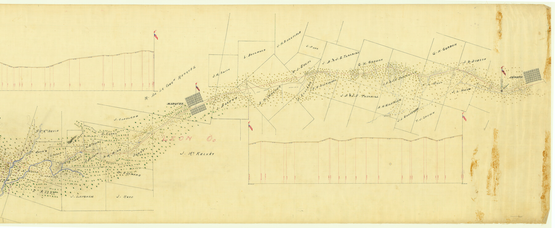
International Railroad Map & Profile of the First Fifty Miles East of Brazos River
Segment 1, Sheet 2
Z-2-130
-
Map/Doc
64464
-
Collection
General Map Collection
-
Object Dates
1877 (Creation Date)
1877/1/12 (File Date)
-
Counties
Robertson Leon
-
Subjects
Railroads
-
Height x Width
18.8 x 45.7 inches
47.8 x 116.1 cm
-
Medium
linen, manuscript
-
Scale
2000 ft to 1 in.
-
Comments
East of the Brazos River.
See Segment 1, Sheet 1 (64463)
See Segment 2, International Railroad Map & Profile of the Second Fifty Miles East of Brazos River, Sheet 1 (64465) and Sheet 2 (64466) -
Features
IRRC
Narasoto River
Brushy Creek
Winns Branch
Winns Prairie
Marquez
Hog Pen Prairie
Jewett
Related maps
International Railroad Map & Profile of the First Fifty Miles East of Brazos River

Print $40.00
- Digital $50.00
International Railroad Map & Profile of the First Fifty Miles East of Brazos River
1877
Size 19.5 x 84.9 inches
Map/Doc 64463
International Railroad Map & Profile of the Second Fifty Miles East of Brazos River

Print $40.00
- Digital $50.00
International Railroad Map & Profile of the Second Fifty Miles East of Brazos River
1877
Size 19.8 x 76.6 inches
Map/Doc 64465
International Railroad Map & Profile of the Second Fifty Miles East of Brazos River

Print $40.00
- Digital $50.00
International Railroad Map & Profile of the Second Fifty Miles East of Brazos River
1877
Size 19.0 x 52.0 inches
Map/Doc 64466
Part of: General Map Collection
Zavala County Sketch File 25

Print $4.00
- Digital $50.00
Zavala County Sketch File 25
1886
Size 14.5 x 8.8 inches
Map/Doc 41388
Flight Mission No. DQN-2K, Frame 87, Calhoun County

Print $20.00
- Digital $50.00
Flight Mission No. DQN-2K, Frame 87, Calhoun County
1953
Size 18.9 x 22.6 inches
Map/Doc 84277
Uvalde County Sketch File 27

Print $20.00
- Digital $50.00
Uvalde County Sketch File 27
1972
Size 18.7 x 14.0 inches
Map/Doc 75972
El Paso County Sketch File 11

Print $6.00
- Digital $50.00
El Paso County Sketch File 11
Size 14.2 x 11.0 inches
Map/Doc 22000
Kinney County Working Sketch 46

Print $20.00
- Digital $50.00
Kinney County Working Sketch 46
1978
Size 44.3 x 35.1 inches
Map/Doc 70228
Leon County Rolled Sketch 20

Print $20.00
- Digital $50.00
Leon County Rolled Sketch 20
Size 27.0 x 25.8 inches
Map/Doc 6607
South Part Pecos County

Print $20.00
- Digital $50.00
South Part Pecos County
1976
Size 35.0 x 42.9 inches
Map/Doc 77393
Presidio County Working Sketch 5

Print $20.00
- Digital $50.00
Presidio County Working Sketch 5
1917
Size 14.0 x 17.5 inches
Map/Doc 71679
[Map of Coahuila and Nuevo Leon]
![97128, [Map of Coahuila and Nuevo Leon], General Map Collection](https://historictexasmaps.com/wmedia_w700/maps/97128.tif.jpg)
Print $20.00
- Digital $50.00
[Map of Coahuila and Nuevo Leon]
1873
Size 16.8 x 11.6 inches
Map/Doc 97128
Runnels County Working Sketch 15

Print $20.00
- Digital $50.00
Runnels County Working Sketch 15
1950
Size 22.8 x 18.5 inches
Map/Doc 63611
Crane County Working Sketch 22

Print $20.00
- Digital $50.00
Crane County Working Sketch 22
1961
Size 44.7 x 43.9 inches
Map/Doc 68299
Kinney County Working Sketch 49

Print $20.00
- Digital $50.00
Kinney County Working Sketch 49
1980
Size 19.9 x 25.6 inches
Map/Doc 70231
You may also like
Map of Jack County

Print $20.00
- Digital $50.00
Map of Jack County
1874
Size 20.7 x 17.6 inches
Map/Doc 3704
Grayson County Working Sketch 9

Print $20.00
- Digital $50.00
Grayson County Working Sketch 9
1946
Size 44.8 x 31.7 inches
Map/Doc 63248
Trinity River, Cox Bluff Sheet

Print $20.00
- Digital $50.00
Trinity River, Cox Bluff Sheet
1926
Size 36.0 x 46.2 inches
Map/Doc 65214
Sterling County Rolled Sketch 26

Print $20.00
- Digital $50.00
Sterling County Rolled Sketch 26
1955
Size 23.8 x 21.4 inches
Map/Doc 7851
Texas Intracoastal Waterway - Stover Point to Port Brownsville including Brazos Santiago

Print $20.00
- Digital $50.00
Texas Intracoastal Waterway - Stover Point to Port Brownsville including Brazos Santiago
1961
Size 27.2 x 38.9 inches
Map/Doc 73519
Cass County Rolled Sketch OF

Print $20.00
- Digital $50.00
Cass County Rolled Sketch OF
1937
Size 16.2 x 24.3 inches
Map/Doc 5414
Dimmit County Boundary File 10

Print $32.00
- Digital $50.00
Dimmit County Boundary File 10
Size 14.2 x 8.6 inches
Map/Doc 52604
Rains County Rolled Sketch 2

Print $41.00
- Digital $50.00
Rains County Rolled Sketch 2
1958
Size 10.4 x 15.4 inches
Map/Doc 48829
Val Verde County Boundary File 1

Print $6.00
- Digital $50.00
Val Verde County Boundary File 1
Size 14.3 x 8.7 inches
Map/Doc 59572
Fractional Township No. 7 South Range No. 6 East of the Indian Meridian, Indian Territory

Print $20.00
- Digital $50.00
Fractional Township No. 7 South Range No. 6 East of the Indian Meridian, Indian Territory
1898
Size 19.2 x 24.3 inches
Map/Doc 75211
The Mexican Municipality of Brazoria. March 6, 1834

Print $20.00
The Mexican Municipality of Brazoria. March 6, 1834
2020
Size 16.0 x 21.7 inches
Map/Doc 96016
Arizona Chemical Co. Brownfield Plant

Print $20.00
- Digital $50.00
Arizona Chemical Co. Brownfield Plant
Size 28.3 x 19.9 inches
Map/Doc 92892