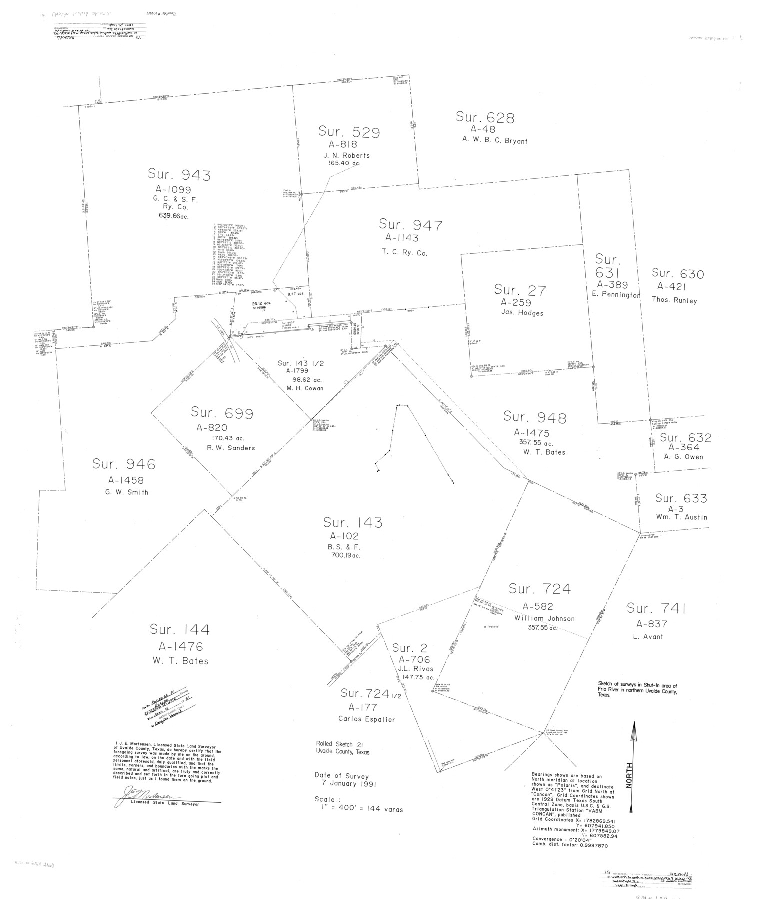
Uvalde County Rolled Sketch 21
Sketch of surveys in shut-in area of Frio River in northern Uvalde County, Texas
-
Map/Doc
10067
-
Collection
General Map Collection
-
Object Dates
1991/1/7 (Survey Date)
1991/4/15 (File Date)
-
People and Organizations
James E. Mortensen (Surveyor/Engineer)
-
Counties
Uvalde
-
Subjects
Surveying Rolled Sketch
-
Height x Width
54.1 x 45.6 inches
137.4 x 115.8 cm
-
Medium
mylar, print
-
Scale
1" = 144 varas
Part of: General Map Collection
Victoria County

Print $20.00
- Digital $50.00
Victoria County
1895
Size 29.7 x 25.7 inches
Map/Doc 4118
Dallas County Working Sketch 16

Print $20.00
- Digital $50.00
Dallas County Working Sketch 16
1981
Size 15.7 x 12.0 inches
Map/Doc 68582
Montgomery County Sketch File 20

Print $38.00
- Digital $50.00
Montgomery County Sketch File 20
1932
Size 14.3 x 8.8 inches
Map/Doc 31847
Fort Bend County Sketch File 13

Print $30.00
- Digital $50.00
Fort Bend County Sketch File 13
1888
Size 14.3 x 8.8 inches
Map/Doc 22908
Lee County Sketch File 1

Print $4.00
- Digital $50.00
Lee County Sketch File 1
1856
Size 13.1 x 8.2 inches
Map/Doc 29678
Sabine County Sketch File 7

Print $2.00
Sabine County Sketch File 7
1882
Size 8.6 x 12.7 inches
Map/Doc 35619
Gaines County Boundary File 4

Print $4.00
- Digital $50.00
Gaines County Boundary File 4
Size 14.4 x 8.9 inches
Map/Doc 53656
Nueces County Rolled Sketch 108

Print $62.00
Nueces County Rolled Sketch 108
1987
Size 18.6 x 23.5 inches
Map/Doc 7112
Fannin County Boundary File 7

Print $42.00
- Digital $50.00
Fannin County Boundary File 7
Size 5.3 x 31.1 inches
Map/Doc 53313
Dimmit County Boundary File 5

Print $6.00
- Digital $50.00
Dimmit County Boundary File 5
Size 11.1 x 8.6 inches
Map/Doc 52577
Clay County Sketch File 16

Print $9.00
- Digital $50.00
Clay County Sketch File 16
1874
Size 8.3 x 7.9 inches
Map/Doc 18421
Coast Chart No. 209 - Aransas Pass, Aransas and Copano Bays, Texas

Print $20.00
- Digital $50.00
Coast Chart No. 209 - Aransas Pass, Aransas and Copano Bays, Texas
1906
Size 40.2 x 33.8 inches
Map/Doc 73430
You may also like
Newton County Rolled Sketch 4

Print $20.00
- Digital $50.00
Newton County Rolled Sketch 4
1893
Size 21.1 x 19.7 inches
Map/Doc 6840
Dallas County Sketch File 17

Print $20.00
- Digital $50.00
Dallas County Sketch File 17
Size 17.1 x 18.0 inches
Map/Doc 11285
[San Antonio & Galveston RR]
![64149, [San Antonio & Galveston RR], General Map Collection](https://historictexasmaps.com/wmedia_w700/maps/64149.tif.jpg)
Print $20.00
- Digital $50.00
[San Antonio & Galveston RR]
Size 37.6 x 11.2 inches
Map/Doc 64149
Nueces County NRC Article 33.136 Location Key Sheet

Print $20.00
- Digital $50.00
Nueces County NRC Article 33.136 Location Key Sheet
1975
Size 27.0 x 23.0 inches
Map/Doc 88585
Harris County Working Sketch 8

Print $20.00
- Digital $50.00
Harris County Working Sketch 8
1904
Size 26.8 x 23.3 inches
Map/Doc 65900
Young County Working Sketch 19

Print $20.00
- Digital $50.00
Young County Working Sketch 19
1961
Size 27.2 x 23.7 inches
Map/Doc 62042
Map of Haskell County

Print $20.00
- Digital $50.00
Map of Haskell County
1899
Size 40.1 x 35.3 inches
Map/Doc 16847
Jack County Sketch File 30

Print $20.00
- Digital $50.00
Jack County Sketch File 30
Size 24.9 x 34.7 inches
Map/Doc 11829
[Old Coastal Chart showing Brazo Chico, Brazo de Santiago and Rio Bravo del Norte passes with depth readings]
![4661, [Old Coastal Chart showing Brazo Chico, Brazo de Santiago and Rio Bravo del Norte passes with depth readings], General Map Collection](https://historictexasmaps.com/wmedia_w700/maps/4661-1.tif.jpg)
Print $20.00
- Digital $50.00
[Old Coastal Chart showing Brazo Chico, Brazo de Santiago and Rio Bravo del Norte passes with depth readings]
1837
Size 25.7 x 39.3 inches
Map/Doc 4661
Flight Mission No. DQO-8K, Frame 112, Galveston County

Print $20.00
- Digital $50.00
Flight Mission No. DQO-8K, Frame 112, Galveston County
1952
Size 18.6 x 22.4 inches
Map/Doc 85194
Progressive Military Map of the United States, Southern Department, Sheet 403N, Comstock

Print $20.00
- Digital $50.00
Progressive Military Map of the United States, Southern Department, Sheet 403N, Comstock
1916
Size 35.0 x 23.9 inches
Map/Doc 92062
Duval County Sketch File 43

Print $20.00
- Digital $50.00
Duval County Sketch File 43
Size 22.9 x 21.1 inches
Map/Doc 11398