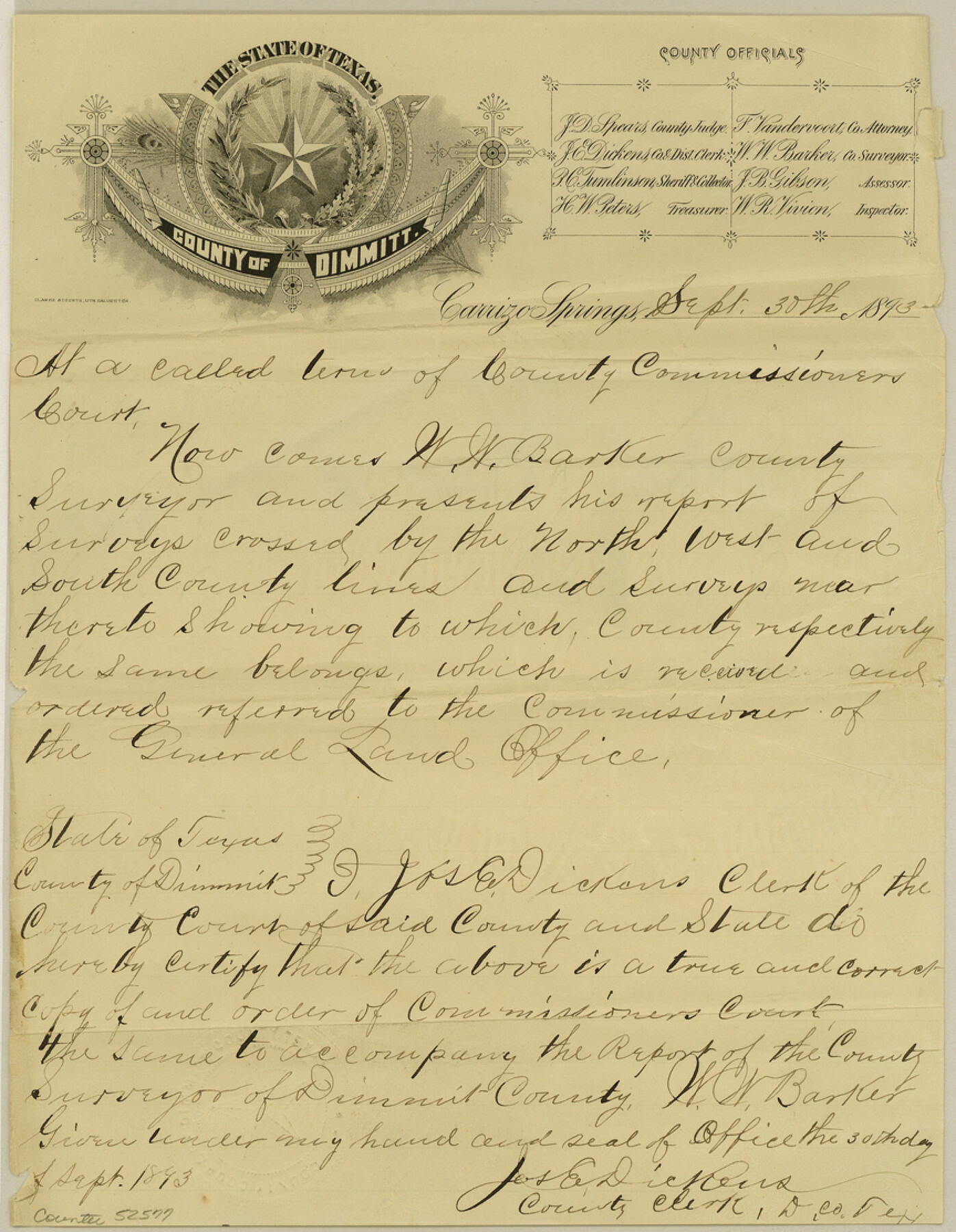
Dimmit County Boundary File 5
Cert. Copy of Order of Commis. Ct.
-
Map/Doc
52577
-
Collection
General Map Collection
-
Counties
Dimmit
-
Subjects
County Boundaries
-
Height x Width
11.1 x 8.6 inches
28.2 x 21.8 cm
Part of: General Map Collection
Flight Mission No. BQR-13K, Frame 26, Brazoria County

Print $20.00
- Digital $50.00
Flight Mission No. BQR-13K, Frame 26, Brazoria County
1952
Size 18.7 x 22.4 inches
Map/Doc 84074
Medina County

Print $40.00
- Digital $50.00
Medina County
1915
Size 50.0 x 42.0 inches
Map/Doc 66925
Crane County Working Sketch 5

Print $40.00
- Digital $50.00
Crane County Working Sketch 5
1928
Size 34.5 x 49.0 inches
Map/Doc 68282
Wise County Sketch File 13

Print $4.00
- Digital $50.00
Wise County Sketch File 13
Size 9.0 x 15.2 inches
Map/Doc 40546
Schleicher County Rolled Sketch 13

Print $20.00
- Digital $50.00
Schleicher County Rolled Sketch 13
Size 37.2 x 30.8 inches
Map/Doc 7756
Galveston County Rolled Sketch 34A

Print $20.00
- Digital $50.00
Galveston County Rolled Sketch 34A
1978
Size 30.2 x 40.9 inches
Map/Doc 5967
Freestone County Sketch File 7

Print $4.00
- Digital $50.00
Freestone County Sketch File 7
1861
Size 14.4 x 8.3 inches
Map/Doc 23052
Coast Chart No. 210 Aransas Pass and Corpus Christi Bay with the coast to latitude 27° 12' Texas

Print $20.00
- Digital $50.00
Coast Chart No. 210 Aransas Pass and Corpus Christi Bay with the coast to latitude 27° 12' Texas
1913
Size 26.8 x 18.2 inches
Map/Doc 72808
Tyler County Working Sketch 19

Print $20.00
- Digital $50.00
Tyler County Working Sketch 19
1967
Size 47.8 x 42.9 inches
Map/Doc 69489
San Jacinto County Working Sketch 8
Print $20.00
- Digital $50.00
San Jacinto County Working Sketch 8
1935
Size 38.4 x 42.9 inches
Map/Doc 63721
Culberson County Sketch File 10a

Print $20.00
- Digital $50.00
Culberson County Sketch File 10a
1926
Size 11.9 x 18.3 inches
Map/Doc 11264
Starr County Sketch File 31A

Print $20.00
- Digital $50.00
Starr County Sketch File 31A
1936
Size 24.5 x 13.3 inches
Map/Doc 12335
You may also like
Anderson County Working Sketch 7

Print $20.00
- Digital $50.00
Anderson County Working Sketch 7
1920
Size 27.3 x 30.2 inches
Map/Doc 67006
The Chief Justice County of Washington. Lands in Conflict with Nacogdoches County

Print $20.00
The Chief Justice County of Washington. Lands in Conflict with Nacogdoches County
2020
Size 13.0 x 21.7 inches
Map/Doc 96078
Nolan County Working Sketch 9

Print $20.00
- Digital $50.00
Nolan County Working Sketch 9
1964
Size 25.0 x 36.8 inches
Map/Doc 71300
Kaufman County Boundary File 3a

Print $28.00
- Digital $50.00
Kaufman County Boundary File 3a
Size 14.2 x 8.6 inches
Map/Doc 55929
Presidio County Rolled Sketch 65

Print $20.00
- Digital $50.00
Presidio County Rolled Sketch 65
Size 23.1 x 28.3 inches
Map/Doc 7356
Pecos County Sketch File 46

Print $26.00
- Digital $50.00
Pecos County Sketch File 46
1921
Size 11.4 x 8.9 inches
Map/Doc 33746
Dimmit County Working Sketch 42

Print $20.00
- Digital $50.00
Dimmit County Working Sketch 42
1977
Size 33.5 x 39.6 inches
Map/Doc 68703
Seminole, Gaines County, Texas

Print $20.00
- Digital $50.00
Seminole, Gaines County, Texas
Size 25.6 x 39.0 inches
Map/Doc 92692
Randall County

Print $20.00
- Digital $50.00
Randall County
1917
Size 45.2 x 38.9 inches
Map/Doc 73339
Official Map of the Highway System of Texas

Digital $50.00
Official Map of the Highway System of Texas
1935
Size 25.1 x 25.9 inches
Map/Doc 93721
King County Sketch File 4

Print $22.00
- Digital $50.00
King County Sketch File 4
Size 8.8 x 14.2 inches
Map/Doc 29022
English Field Notes of the Spanish Archives - Book 10

English Field Notes of the Spanish Archives - Book 10
1835
Map/Doc 96536