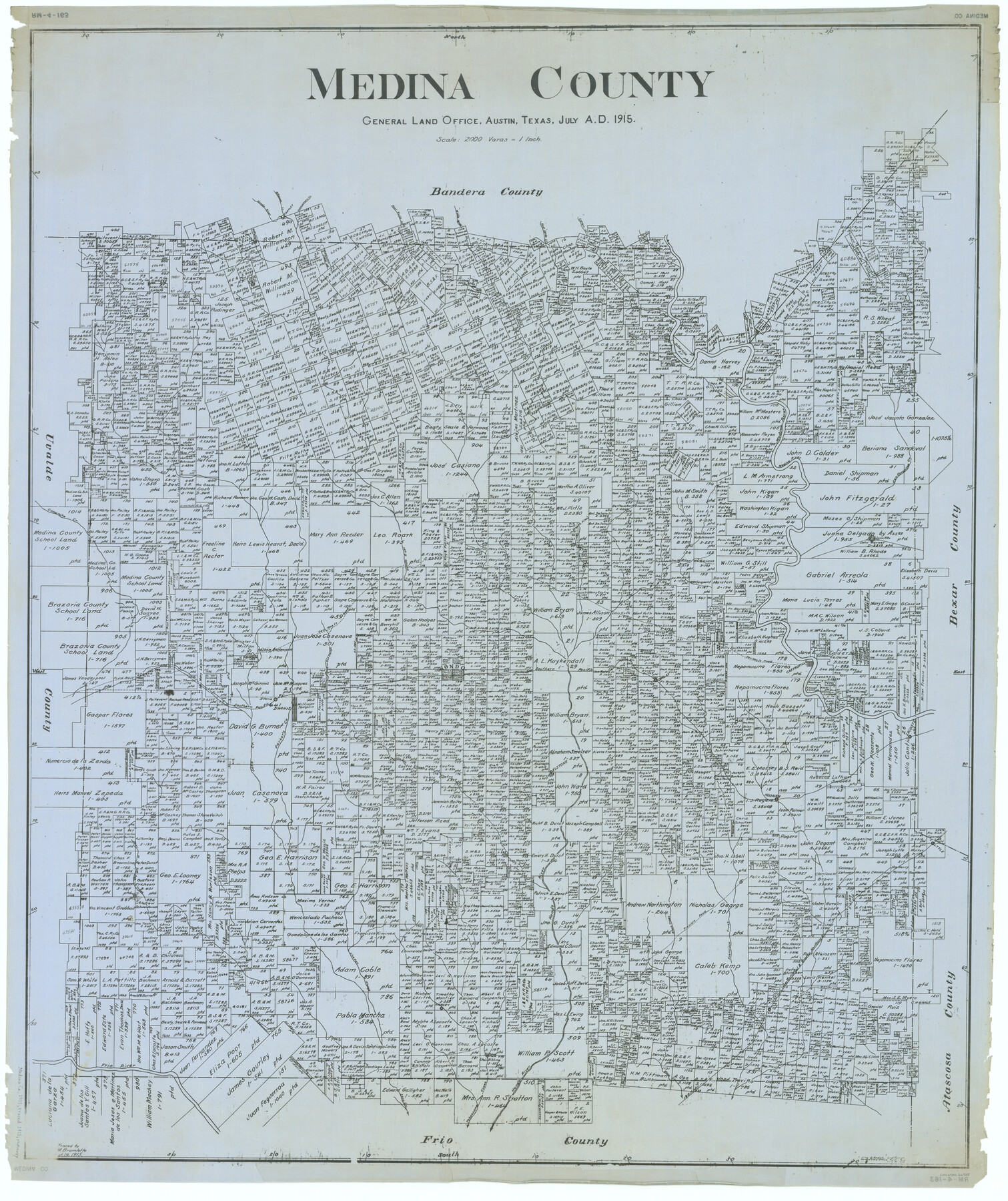
Medina County
RM-4-163
-
Map/Doc
66925
-
Collection
General Map Collection
-
Object Dates
1915/7/30 (Creation Date)
-
People and Organizations
Texas General Land Office (Publisher)
John D. Hedick (Compiler)
John D. Hedick (Draftsman)
-
Counties
Medina
-
Subjects
County
-
Height x Width
50.0 x 42.0 inches
127.0 x 106.7 cm
-
Comments
Traced September 14, 1915 by H. M. Bramlette.
Part of: General Map Collection
Hockley County Sketch File 7

Print $20.00
- Digital $50.00
Hockley County Sketch File 7
Size 21.0 x 22.5 inches
Map/Doc 11770

Tarrant County Working Sketch 21

Print $20.00
- Digital $50.00
Tarrant County Working Sketch 21
1999
Size 17.4 x 22.8 inches
Map/Doc 62438
Hudspeth County Sketch File 37

Print $80.00
- Digital $50.00
Hudspeth County Sketch File 37
Size 12.5 x 98.3 inches
Map/Doc 27008
Lubbock County Rolled Sketch 7

Print $20.00
- Digital $50.00
Lubbock County Rolled Sketch 7
1944
Size 25.8 x 32.9 inches
Map/Doc 6643

Lee County Sketch File 8

Print $6.00
- Digital $50.00
Lee County Sketch File 8
1838
Size 12.8 x 8.3 inches
Map/Doc 29706
Atascosa County Rolled Sketch 4

Print $20.00
- Digital $50.00
Atascosa County Rolled Sketch 4
Size 21.0 x 15.8 inches
Map/Doc 5087
Presidio County Rolled Sketch 133

Print $20.00
- Digital $50.00
Presidio County Rolled Sketch 133
Size 37.3 x 27.2 inches
Map/Doc 7400
Marion County Working Sketch Graphic Index, Sheet 1 (Sketches 1 to 26)

Print $20.00
- Digital $50.00
Marion County Working Sketch Graphic Index, Sheet 1 (Sketches 1 to 26)
1943
Size 26.8 x 45.1 inches
Map/Doc 76629
Map of Walker County

Print $20.00
- Digital $50.00
Map of Walker County
1858
Size 22.9 x 34.1 inches
Map/Doc 4120
Robertson County Working Sketch 9

Print $20.00
- Digital $50.00
Robertson County Working Sketch 9
1984
Size 19.9 x 21.5 inches
Map/Doc 63582
You may also like
Carta Esferica Del Reyno De Mexico y parte de la America Setentrional, Para inteligencia de la Obra intitulada: Descubrimiento y Conquista de la America

Print $20.00
- Digital $50.00
Carta Esferica Del Reyno De Mexico y parte de la America Setentrional, Para inteligencia de la Obra intitulada: Descubrimiento y Conquista de la America
1802
Size 15.1 x 20.5 inches
Map/Doc 97410
The Mexican Municipalities. On the Eve of Texas Independence, 1836

Print $20.00
The Mexican Municipalities. On the Eve of Texas Independence, 1836
2020
Size 17.2 x 21.6 inches
Map/Doc 96013
[Surveys in Cherokee County]
![251, [Surveys in Cherokee County], General Map Collection](https://historictexasmaps.com/wmedia_w700/maps/251.tif.jpg)
Print $2.00
- Digital $50.00
[Surveys in Cherokee County]
Size 8.0 x 5.6 inches
Map/Doc 251
Wichita County Sketch File H

Print $4.00
- Digital $50.00
Wichita County Sketch File H
1884
Size 12.8 x 8.2 inches
Map/Doc 40089
Fort Bend County State Real Property Sketch 18

Print $40.00
- Digital $50.00
Fort Bend County State Real Property Sketch 18
2006
Size 17.7 x 24.0 inches
Map/Doc 88615
[Surveys along the boundary between Jasper and Jefferson Counties]
![99, [Surveys along the boundary between Jasper and Jefferson Counties], General Map Collection](https://historictexasmaps.com/wmedia_w700/maps/99.tif.jpg)
Print $3.00
- Digital $50.00
[Surveys along the boundary between Jasper and Jefferson Counties]
1841
Size 9.3 x 16.9 inches
Map/Doc 99
Map of Hamilton County

Print $20.00
- Digital $50.00
Map of Hamilton County
1872
Size 14.9 x 21.9 inches
Map/Doc 4556
Intracoastal Waterway, Houma, LA to Corpus Christi, TX

Print $4.00
- Digital $50.00
Intracoastal Waterway, Houma, LA to Corpus Christi, TX
Size 23.8 x 22.0 inches
Map/Doc 61910
Hunt County Sketch File 2

Print $4.00
- Digital $50.00
Hunt County Sketch File 2
1857
Size 10.1 x 7.8 inches
Map/Doc 27083
Presidio County Sketch File 89

Print $10.00
- Digital $50.00
Presidio County Sketch File 89
1953
Size 14.3 x 8.9 inches
Map/Doc 34756
Motley County Sketch File 15 (N)

Print $20.00
- Digital $50.00
Motley County Sketch File 15 (N)
Size 20.6 x 26.0 inches
Map/Doc 42143
Childress County Working Sketch Graphic Index

Print $20.00
- Digital $50.00
Childress County Working Sketch Graphic Index
1978
Size 45.5 x 34.3 inches
Map/Doc 76493