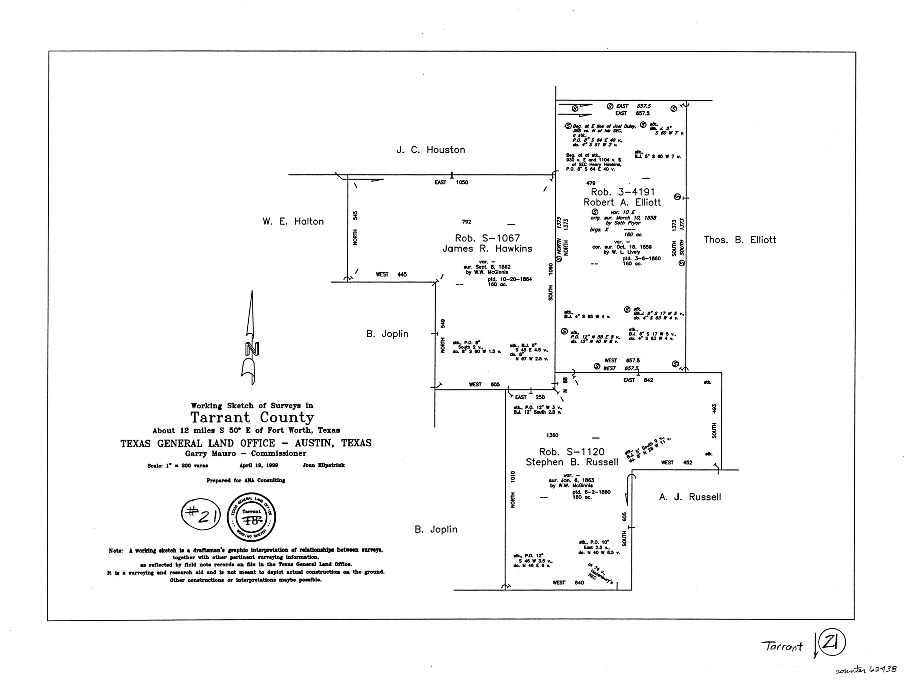
Tarrant County Working Sketch 21
-
Map/Doc
62438
-
Collection
General Map Collection
-
Object Dates
4/19/1999 (Creation Date)
-
People and Organizations
Joan Kilpatrick (Draftsman)
-
Counties
Tarrant
-
Subjects
Surveying Working Sketch
-
Height x Width
17.4 x 22.8 inches
44.2 x 57.9 cm
-
Scale
1" = 200 varas
Part of: General Map Collection
Hutchinson County Boundary File 5

Print $22.00
- Digital $50.00
Hutchinson County Boundary File 5
Size 4.3 x 45.7 inches
Map/Doc 55314
Freestone County Working Sketch 4

Print $20.00
- Digital $50.00
Freestone County Working Sketch 4
1921
Size 29.6 x 22.7 inches
Map/Doc 69246
Starr County Rolled Sketch 35

Print $20.00
- Digital $50.00
Starr County Rolled Sketch 35
1925
Size 40.1 x 12.8 inches
Map/Doc 7832
Northwest Part Pecos County

Print $20.00
- Digital $50.00
Northwest Part Pecos County
1975
Size 42.2 x 42.2 inches
Map/Doc 77395
Jefferson County Working Sketch 5

Print $20.00
- Digital $50.00
Jefferson County Working Sketch 5
1930
Size 32.7 x 21.8 inches
Map/Doc 66548
Newton County Working Sketch 40

Print $20.00
- Digital $50.00
Newton County Working Sketch 40
1970
Size 43.6 x 39.7 inches
Map/Doc 71286
Menard County Working Sketch 33

Print $20.00
- Digital $50.00
Menard County Working Sketch 33
1989
Size 27.2 x 25.2 inches
Map/Doc 70980
Sutton County Rolled Sketch 58

Print $20.00
- Digital $50.00
Sutton County Rolled Sketch 58
Size 31.2 x 15.9 inches
Map/Doc 7896
McMullen County Working Sketch 60

Print $20.00
- Digital $50.00
McMullen County Working Sketch 60
1987
Size 23.0 x 32.6 inches
Map/Doc 70761
Flight Mission No. CGI-4N, Frame 193, Cameron County

Print $20.00
- Digital $50.00
Flight Mission No. CGI-4N, Frame 193, Cameron County
1955
Size 18.6 x 22.3 inches
Map/Doc 84696
Ector County Working Sketch 8

Print $20.00
- Digital $50.00
Ector County Working Sketch 8
1944
Size 40.5 x 26.5 inches
Map/Doc 68851
Flight Mission No. BRA-7M, Frame 145, Jefferson County

Print $20.00
- Digital $50.00
Flight Mission No. BRA-7M, Frame 145, Jefferson County
1953
Size 16.0 x 16.0 inches
Map/Doc 85539
You may also like
[Portion of Harris County]
![78482, [Portion of Harris County], General Map Collection](https://historictexasmaps.com/wmedia_w700/maps/78482.tif.jpg)
Print $2.00
- Digital $50.00
[Portion of Harris County]
Size 9.8 x 7.2 inches
Map/Doc 78482
Bell County Working Sketch 16

Print $20.00
- Digital $50.00
Bell County Working Sketch 16
1983
Size 46.5 x 35.4 inches
Map/Doc 67356
Correct Map of Texas

Print $20.00
- Digital $50.00
Correct Map of Texas
1873
Size 21.3 x 16.9 inches
Map/Doc 95776
Crockett County Rolled Sketch 84

Print $20.00
- Digital $50.00
Crockett County Rolled Sketch 84
1961
Size 31.9 x 25.2 inches
Map/Doc 5624

Val Verde County Working Sketch 83

Print $40.00
- Digital $50.00
Val Verde County Working Sketch 83
1973
Size 28.7 x 53.6 inches
Map/Doc 72218
Olney's School Atlas

Print $326.00
- Digital $50.00
Olney's School Atlas
1844
Size 12.3 x 10.0 inches
Map/Doc 93534

Houston County Sketch File 34

Print $6.00
- Digital $50.00
Houston County Sketch File 34
1914
Size 13.3 x 11.0 inches
Map/Doc 26811
Gillespie County Sketch File 11

Print $4.00
- Digital $50.00
Gillespie County Sketch File 11
1877
Size 8.3 x 12.8 inches
Map/Doc 24149
Bee County Working Sketch 5

Print $20.00
- Digital $50.00
Bee County Working Sketch 5
1930
Size 21.1 x 14.5 inches
Map/Doc 67255
Bell County Working Sketch 4

Print $20.00
- Digital $50.00
Bell County Working Sketch 4
1942
Size 26.9 x 21.0 inches
Map/Doc 67344