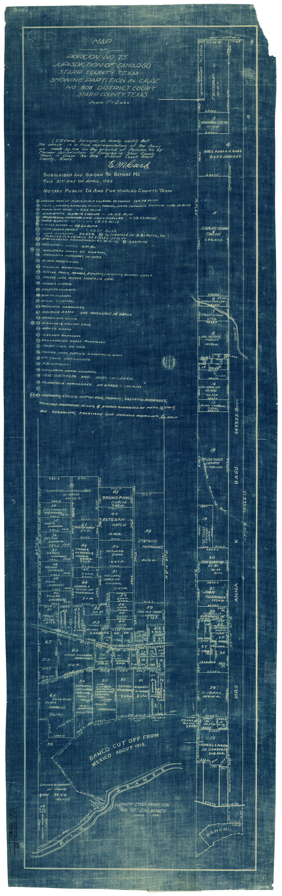
Starr County Rolled Sketch 35
Map of Porcion no. 75, Jurisdiction of Camargo, Starr County, Texas showing partition in Cause no. 806, District Court
-
Map/Doc
7832
-
Collection
General Map Collection
-
Object Dates
4/21/1925 (Creation Date)
-
People and Organizations
E.M. Card (Surveyor/Engineer)
-
Counties
Starr
-
Subjects
Surveying Rolled Sketch
-
Height x Width
40.1 x 12.8 inches
101.9 x 32.5 cm
-
Medium
blueprint/diazo
-
Scale
1" = 2000 varas
Part of: General Map Collection
Flight Mission No. DIX-6P, Frame 196, Aransas County

Print $20.00
- Digital $50.00
Flight Mission No. DIX-6P, Frame 196, Aransas County
1956
Size 18.9 x 22.6 inches
Map/Doc 83858
Gaines County Working Sketch 21

Print $20.00
- Digital $50.00
Gaines County Working Sketch 21
1970
Size 37.8 x 45.4 inches
Map/Doc 69321
Flight Mission No. BRA-16M, Frame 69, Jefferson County

Print $20.00
- Digital $50.00
Flight Mission No. BRA-16M, Frame 69, Jefferson County
1953
Size 18.6 x 22.2 inches
Map/Doc 85686
Blanco County Working Sketch 31

Print $20.00
- Digital $50.00
Blanco County Working Sketch 31
1972
Size 19.1 x 25.7 inches
Map/Doc 67391
Wilson County Working Sketch 4

Print $20.00
- Digital $50.00
Wilson County Working Sketch 4
1953
Size 30.8 x 28.5 inches
Map/Doc 72584
A Map of Part of Panola County [Judicial District]
![328, A Map of Part of Panola County [Judicial District], General Map Collection](https://historictexasmaps.com/wmedia_w700/maps/328.tif.jpg)
Print $20.00
- Digital $50.00
A Map of Part of Panola County [Judicial District]
1841
Size 18.3 x 15.4 inches
Map/Doc 328
Midland County Working Sketch 19a

Print $20.00
- Digital $50.00
Midland County Working Sketch 19a
Size 20.2 x 23.4 inches
Map/Doc 71000
Sabine River, Gladewater Sheet

Print $20.00
- Digital $50.00
Sabine River, Gladewater Sheet
1933
Size 38.5 x 30.9 inches
Map/Doc 65138
Flight Mission No. BRA-16M, Frame 141, Jefferson County

Print $20.00
- Digital $50.00
Flight Mission No. BRA-16M, Frame 141, Jefferson County
1953
Size 18.6 x 22.2 inches
Map/Doc 85747
The Texas & Oklahoma Official Railway & Hotel Guide Map

Print $20.00
- Digital $50.00
The Texas & Oklahoma Official Railway & Hotel Guide Map
1917
Size 23.6 x 24.1 inches
Map/Doc 94032
Pecos County Working Sketch 2

Print $20.00
- Digital $50.00
Pecos County Working Sketch 2
Size 18.1 x 28.3 inches
Map/Doc 71472
Cherokee County Sketch File 35

Print $42.00
- Digital $50.00
Cherokee County Sketch File 35
1955
Size 11.5 x 8.8 inches
Map/Doc 18204
You may also like
Flight Mission No. DQO-1K, Frame 113, Galveston County

Print $20.00
- Digital $50.00
Flight Mission No. DQO-1K, Frame 113, Galveston County
1952
Size 18.9 x 22.7 inches
Map/Doc 84991
Flight Mission No. DAG-24K, Frame 139, Matagorda County

Print $20.00
- Digital $50.00
Flight Mission No. DAG-24K, Frame 139, Matagorda County
1953
Size 18.5 x 22.3 inches
Map/Doc 86557
Fisher County Sketch File 18

Print $12.00
- Digital $50.00
Fisher County Sketch File 18
1901
Size 8.2 x 5.5 inches
Map/Doc 22589
[Tracing from Mabry's Working Sketch in Southwest Oldham County]
![91474, [Tracing from Mabry's Working Sketch in Southwest Oldham County], Twichell Survey Records](https://historictexasmaps.com/wmedia_w700/maps/91474-1.tif.jpg)
Print $20.00
- Digital $50.00
[Tracing from Mabry's Working Sketch in Southwest Oldham County]
Size 19.3 x 19.8 inches
Map/Doc 91474

University Land, Lamar County

Print $20.00
- Digital $50.00
University Land, Lamar County
1906
Size 23.8 x 29.9 inches
Map/Doc 2431
Brazoria County NRC Article 33.136 Sketch 12

Print $26.00
- Digital $50.00
Brazoria County NRC Article 33.136 Sketch 12
2010
Size 21.0 x 34.0 inches
Map/Doc 93407
Chart of the Rio Bravo del Norte traced from a survey made by Henry Austin by Lieut. Bowman, 3d. Infy.

Print $20.00
- Digital $50.00
Chart of the Rio Bravo del Norte traced from a survey made by Henry Austin by Lieut. Bowman, 3d. Infy.
1866
Size 18.1 x 27.2 inches
Map/Doc 72890
Map of Lavaca County

Print $20.00
- Digital $50.00
Map of Lavaca County
1853
Size 20.1 x 20.4 inches
Map/Doc 3801
The Republic County of Liberty. December 7, 1841

Print $20.00
The Republic County of Liberty. December 7, 1841
2020
Size 19.9 x 21.7 inches
Map/Doc 96211
Ward County Working Sketch Graphic Index - sheet B

Print $40.00
- Digital $50.00
Ward County Working Sketch Graphic Index - sheet B
1932
Size 30.5 x 52.5 inches
Map/Doc 76732
[Township 1 North, Range 17 East]
![90771, [Township 1 North, Range 17 East], Twichell Survey Records](https://historictexasmaps.com/wmedia_w700/maps/90771-1.tif.jpg)
Print $2.00
- Digital $50.00
[Township 1 North, Range 17 East]
Size 14.5 x 8.2 inches
Map/Doc 90771