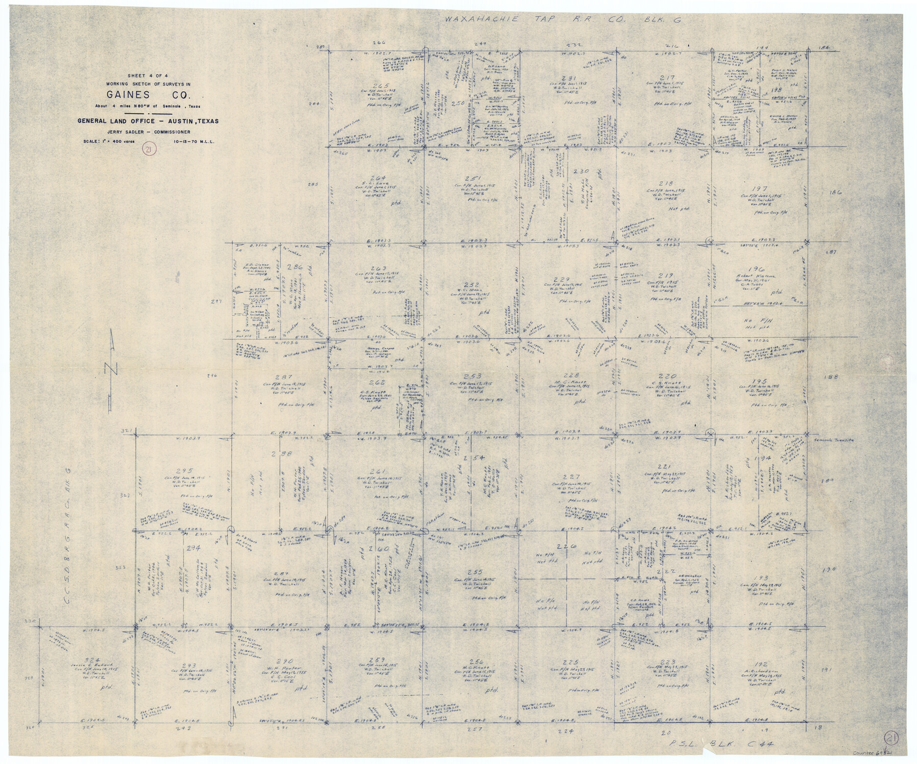
Gaines County Working Sketch 21
-
Map/Doc
69321
-
Collection
General Map Collection
-
Object Dates
10/13/1970 (Creation Date)
-
People and Organizations
M. L. Liles (Draftsman)
-
Counties
Gaines
-
Subjects
Surveying Working Sketch
-
Height x Width
37.8 x 45.4 inches
96.0 x 115.3 cm
-
Scale
1" = 400 varas
Part of: General Map Collection
Outer Continental Shelf Leasing Maps (Texas Offshore Operations)

Print $20.00
- Digital $50.00
Outer Continental Shelf Leasing Maps (Texas Offshore Operations)
1954
Size 14.6 x 15.6 inches
Map/Doc 75836
Real County Rolled Sketch 12A

Print $20.00
- Digital $50.00
Real County Rolled Sketch 12A
Size 36.2 x 38.3 inches
Map/Doc 9837
[Cotton Belt, St. Louis Southwestern Railway of Texas, Alignment through Smith County]
![64375, [Cotton Belt, St. Louis Southwestern Railway of Texas, Alignment through Smith County], General Map Collection](https://historictexasmaps.com/wmedia_w700/maps/64375.tif.jpg)
Print $20.00
- Digital $50.00
[Cotton Belt, St. Louis Southwestern Railway of Texas, Alignment through Smith County]
1903
Size 21.3 x 28.5 inches
Map/Doc 64375
Deaf Smith County Rolled Sketch 3

Print $20.00
- Digital $50.00
Deaf Smith County Rolled Sketch 3
Size 23.9 x 18.0 inches
Map/Doc 95707
Bowie County Sketch File 8f

Print $10.00
- Digital $50.00
Bowie County Sketch File 8f
1928
Size 8.1 x 5.2 inches
Map/Doc 14902
Travis County Working Sketch 6

Print $20.00
- Digital $50.00
Travis County Working Sketch 6
1913
Size 28.9 x 20.6 inches
Map/Doc 69390
Culberson County Working Sketch 72

Print $40.00
- Digital $50.00
Culberson County Working Sketch 72
1975
Size 50.1 x 34.2 inches
Map/Doc 68526
Nueces County Rolled Sketch 2

Print $20.00
- Digital $50.00
Nueces County Rolled Sketch 2
1907
Size 18.4 x 35.8 inches
Map/Doc 6865
Pecos County Sketch File 106

Print $6.00
- Digital $50.00
Pecos County Sketch File 106
1967
Size 14.2 x 8.8 inches
Map/Doc 34030
Hardeman County Working Sketch 7

Print $20.00
- Digital $50.00
Hardeman County Working Sketch 7
1952
Size 34.2 x 30.9 inches
Map/Doc 63388
Bowie County Sketch File 7b

Print $10.00
- Digital $50.00
Bowie County Sketch File 7b
1927
Size 10.7 x 8.6 inches
Map/Doc 14859
Dawson County Boundary File 2

Print $18.00
- Digital $50.00
Dawson County Boundary File 2
Size 14.2 x 8.8 inches
Map/Doc 52338
You may also like
Chambers County Rolled Sketch 25

Print $20.00
- Digital $50.00
Chambers County Rolled Sketch 25
1944
Size 33.9 x 31.5 inches
Map/Doc 8618
Webb County Rolled Sketch 29

Print $20.00
- Digital $50.00
Webb County Rolled Sketch 29
1932
Size 16.5 x 15.3 inches
Map/Doc 8187
Atascosa County Working Sketch 32

Print $20.00
- Digital $50.00
Atascosa County Working Sketch 32
1981
Size 12.9 x 11.8 inches
Map/Doc 67228
Harris County Sketch File 71a

Print $24.00
- Digital $50.00
Harris County Sketch File 71a
1941
Size 11.4 x 8.9 inches
Map/Doc 25525
Val Verde County Working Sketch 93

Print $20.00
- Digital $50.00
Val Verde County Working Sketch 93
1976
Size 40.9 x 40.6 inches
Map/Doc 72228
Limestone County Sketch File A

Print $40.00
- Digital $50.00
Limestone County Sketch File A
1833
Size 15.7 x 12.8 inches
Map/Doc 30149
![90327, [Block B9], Twichell Survey Records](https://historictexasmaps.com/wmedia_w700/maps/90327-1.tif.jpg)
Runnels County Rolled Sketch 1

Print $20.00
- Digital $50.00
Runnels County Rolled Sketch 1
1854
Size 28.0 x 18.4 inches
Map/Doc 75941
Marion County Working Sketch 45

Print $20.00
- Digital $50.00
Marion County Working Sketch 45
2005
Size 27.0 x 29.2 inches
Map/Doc 83576
Hudspeth County Rolled Sketch 32

Print $40.00
- Digital $50.00
Hudspeth County Rolled Sketch 32
Size 32.7 x 94.9 inches
Map/Doc 9211
Coleman County Working Sketch 4

Print $20.00
- Digital $50.00
Coleman County Working Sketch 4
1918
Size 22.7 x 23.6 inches
Map/Doc 68070
Map of part of Waller County

Print $20.00
- Digital $50.00
Map of part of Waller County
Size 16.3 x 13.5 inches
Map/Doc 685