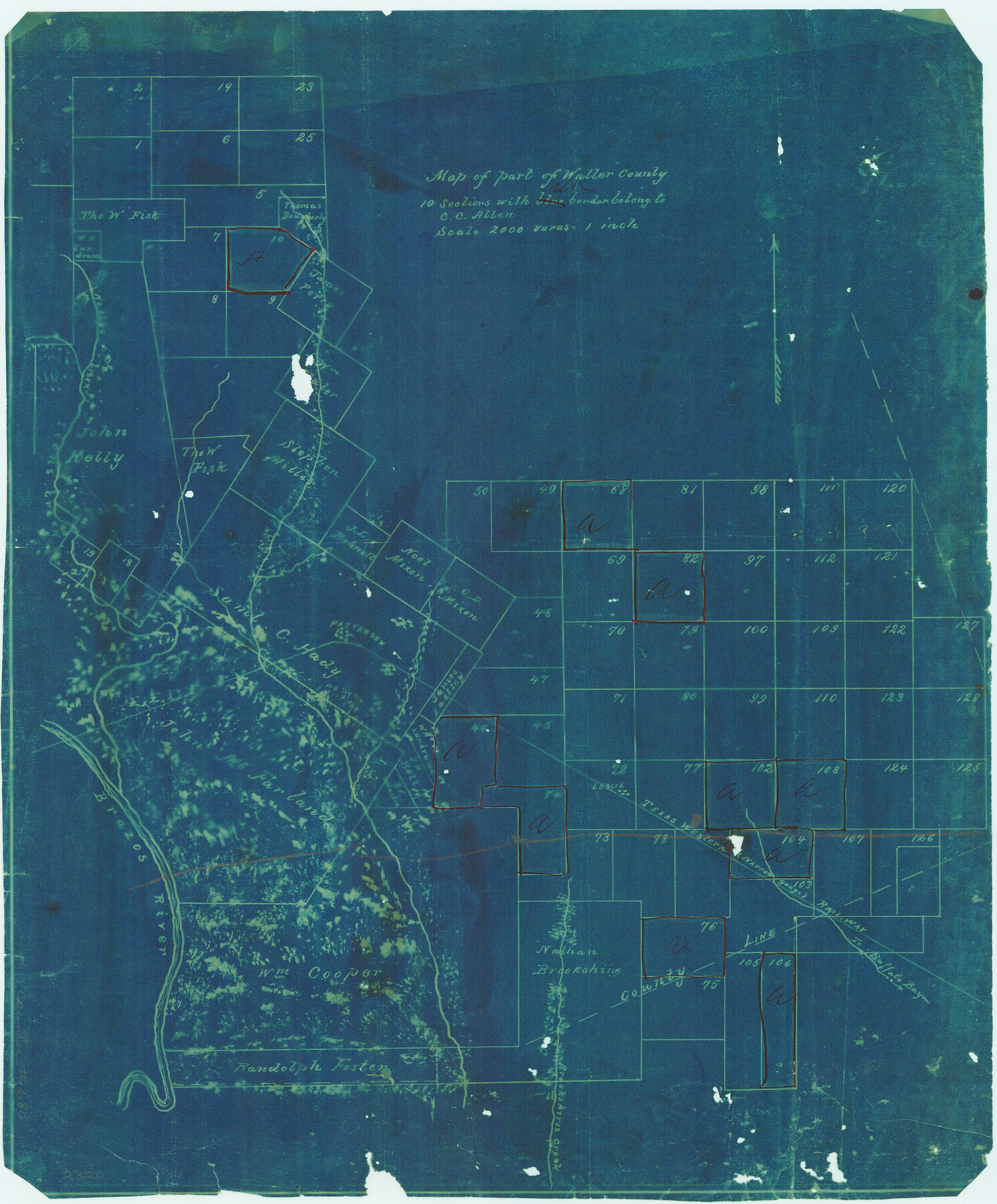
Map of part of Waller County
-
Map/Doc
685
-
Collection
Maddox Collection
-
Counties
Waller Fort Bend
-
Height x Width
16.3 x 13.5 inches
41.4 x 34.3 cm
-
Medium
blueprint/diazo
-
Scale
2000 varas = 1 inch
-
Comments
10 sections without our border belong to C.C. Allen
-
Features
Patterson
Leslie
TWNG
[Road] to Buffalo Bayou
Brazos River
Buffalo Bayou
Brookshires Creek
Irons Creek
Kellys Creek
Part of: Maddox Collection
[Marion County, Texas]
![75777, [Marion County, Texas], Maddox Collection](https://historictexasmaps.com/wmedia_w700/maps/75777.tif.jpg)
Print $20.00
- Digital $50.00
[Marion County, Texas]
1901
Size 26.5 x 24.1 inches
Map/Doc 75777
Map of Frio County, Texas

Print $20.00
- Digital $50.00
Map of Frio County, Texas
1879
Size 24.1 x 22.5 inches
Map/Doc 5032
[Sketch Showing G. H. & H. R.R. Co. Block 3B and A. B. & M. Block M16, Hutchinson County, Texas]
![75813, [Sketch Showing G. H. & H. R.R. Co. Block 3B and A. B. & M. Block M16, Hutchinson County, Texas], Maddox Collection](https://historictexasmaps.com/wmedia_w700/maps/75813.tif.jpg)
Print $20.00
- Digital $50.00
[Sketch Showing G. H. & H. R.R. Co. Block 3B and A. B. & M. Block M16, Hutchinson County, Texas]
Size 20.7 x 21.5 inches
Map/Doc 75813
Map of Hays County, Texas

Print $20.00
- Digital $50.00
Map of Hays County, Texas
1880
Size 24.3 x 21.4 inches
Map/Doc 5029
Shelby County, Texas

Print $20.00
- Digital $50.00
Shelby County, Texas
1880
Size 22.8 x 28.5 inches
Map/Doc 617
Map of Duval County, Texas

Print $20.00
- Digital $50.00
Map of Duval County, Texas
1880
Size 31.4 x 21.8 inches
Map/Doc 5030
Map Showing Position of Surveys Represented Hereon

Print $40.00
- Digital $50.00
Map Showing Position of Surveys Represented Hereon
Size 38.9 x 57.2 inches
Map/Doc 75809
[Map Showing Surveys in Liberty, Chambers and Harris Counties, Texas]
![75768, [Map Showing Surveys in Liberty, Chambers and Harris Counties, Texas], Maddox Collection](https://historictexasmaps.com/wmedia_w700/maps/75768.tif.jpg)
Print $20.00
- Digital $50.00
[Map Showing Surveys in Liberty, Chambers and Harris Counties, Texas]
1890
Size 16.1 x 21.1 inches
Map/Doc 75768
Sketch of a part of Galveston Island

Print $3.00
- Digital $50.00
Sketch of a part of Galveston Island
Size 10.8 x 13.8 inches
Map/Doc 430
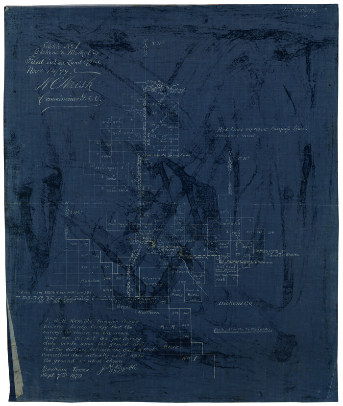
Sketch No. 1, Dickens & Motley Cos.
Print $20.00
- Digital $50.00
Sketch No. 1, Dickens & Motley Cos.
1879
Size 17.9 x 15.5 inches
Map/Doc 10761
Map of Madison County, Texas

Print $20.00
- Digital $50.00
Map of Madison County, Texas
1879
Size 17.1 x 21.7 inches
Map/Doc 643
Wichita County

Print $20.00
- Digital $50.00
Wichita County
1892
Size 20.2 x 24.3 inches
Map/Doc 75804
You may also like
Crosby County Sketch File 5

Print $10.00
- Digital $50.00
Crosby County Sketch File 5
1887
Size 9.2 x 7.8 inches
Map/Doc 20002
Amistad International Reservoir on Rio Grande 82

Print $20.00
- Digital $50.00
Amistad International Reservoir on Rio Grande 82
1949
Size 28.5 x 40.2 inches
Map/Doc 75511
Randall County Rolled Sketch 1

Print $20.00
- Digital $50.00
Randall County Rolled Sketch 1
1889
Size 21.1 x 35.1 inches
Map/Doc 9807

Van Zandt County Sketch File 4

Print $6.00
- Digital $50.00
Van Zandt County Sketch File 4
1858
Size 10.7 x 11.1 inches
Map/Doc 39369
Kaufman County Sketch File 19

Print $30.00
- Digital $50.00
Kaufman County Sketch File 19
1922
Size 11.2 x 8.7 inches
Map/Doc 28666
[Blocks D, Q, and Z]
![92522, [Blocks D, Q, and Z], Twichell Survey Records](https://historictexasmaps.com/wmedia_w700/maps/92522-1.tif.jpg)
Print $20.00
- Digital $50.00
[Blocks D, Q, and Z]
Size 17.9 x 22.6 inches
Map/Doc 92522
San Jacinto County Rolled Sketch 15

Print $20.00
- Digital $50.00
San Jacinto County Rolled Sketch 15
2001
Size 19.2 x 25.2 inches
Map/Doc 7571
Carte Reduite des Costes de la Louisiane et de la Floride

Print $20.00
Carte Reduite des Costes de la Louisiane et de la Floride
1764
Size 23.3 x 35.1 inches
Map/Doc 79295
[John W. Carpenter and Surrounding Surveys]
![91085, [John W. Carpenter and Surrounding Surveys], Twichell Survey Records](https://historictexasmaps.com/wmedia_w700/maps/91085-1.tif.jpg)
Print $20.00
- Digital $50.00
[John W. Carpenter and Surrounding Surveys]
1922
Size 17.7 x 29.6 inches
Map/Doc 91085
General Highway Map, Carson County, Texas

Print $20.00
General Highway Map, Carson County, Texas
1961
Size 18.2 x 24.9 inches
Map/Doc 79401
Edwards County Sketch File 9

Print $20.00
- Digital $50.00
Edwards County Sketch File 9
Size 16.9 x 37.8 inches
Map/Doc 10443