Waller County Sketch File 1a

Print $20.00
- Digital $50.00
Waller County Sketch File 1a
Size: 25.4 x 16.6 inches
12598
Austin County Sketch File 16

Print $74.00
- Digital $50.00
Austin County Sketch File 16
Size: 14.3 x 8.8 inches
13888
Map of Waller County

Print $20.00
- Digital $50.00
Map of Waller County
1897
Size: 46.7 x 28.9 inches
16915
Fort Bend County Sketch File 8

Print $6.00
- Digital $50.00
Fort Bend County Sketch File 8
Size: 6.3 x 4.2 inches
22894
Fort Bend County Sketch File 18a

Print $42.00
- Digital $50.00
Fort Bend County Sketch File 18a
1890
Size: 14.7 x 8.7 inches
22940
Harris County Sketch File 15

Print $4.00
- Digital $50.00
Harris County Sketch File 15
Size: 8.0 x 8.9 inches
25359
Harris County Sketch File 18

Print $6.00
- Digital $50.00
Harris County Sketch File 18
1860
Size: 8.0 x 3.4 inches
25363
Harris County Sketch File 100

Print $518.00
- Digital $50.00
Harris County Sketch File 100
1991
Size: 11.5 x 8.8 inches
25674
Montgomery County Sketch File 1

Print $4.00
- Digital $50.00
Montgomery County Sketch File 1
Size: 11.4 x 8.0 inches
31762
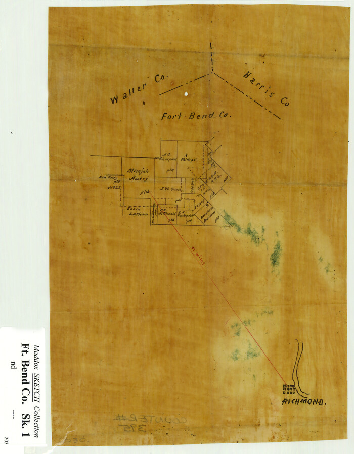
[Sketch Showing Surveys Adjacent to Richmond, Fort Bend County, Texas]
Print $2.00
- Digital $50.00
[Sketch Showing Surveys Adjacent to Richmond, Fort Bend County, Texas]
Size: 9.9 x 7.7 inches
395
Waller County Sketch File 1

Print $14.00
- Digital $50.00
Waller County Sketch File 1
Size: 8.1 x 6.9 inches
39563
Waller County Sketch File 2

Print $52.00
- Digital $50.00
Waller County Sketch File 2
Size: 13.3 x 9.0 inches
39570
Waller County Sketch File 2a

Print $4.00
- Digital $50.00
Waller County Sketch File 2a
Size: 8.0 x 8.4 inches
39596
Waller County Sketch File 3

Print $4.00
- Digital $50.00
Waller County Sketch File 3
Size: 13.0 x 8.4 inches
39598
Waller County Sketch File 5

Print $6.00
- Digital $50.00
Waller County Sketch File 5
Size: 10.7 x 14.1 inches
39600
Waller County Sketch File 6

Print $12.00
- Digital $50.00
Waller County Sketch File 6
Size: 13.1 x 6.3 inches
39602
Waller County Sketch File 7

Print $4.00
- Digital $50.00
Waller County Sketch File 7
1873
Size: 9.4 x 8.2 inches
39608
Waller County Sketch File 9

Print $4.00
- Digital $50.00
Waller County Sketch File 9
Size: 9.1 x 7.8 inches
39610
Waller County Sketch File 10

Print $4.00
- Digital $50.00
Waller County Sketch File 10
1912
Size: 12.4 x 8.6 inches
39612
Waller County Sketch File 11

Print $40.00
- Digital $50.00
Waller County Sketch File 11
1913
Size: 16.6 x 14.3 inches
39614
Waller County Sketch File 12

Print $6.00
- Digital $50.00
Waller County Sketch File 12
1928
Size: 7.6 x 8.8 inches
39616
Harris County Rolled Sketch 28(1)

Print $39.00
- Digital $50.00
Harris County Rolled Sketch 28(1)
Size: 10.0 x 15.3 inches
45770
Fort Bend County Rolled Sketch 30 1/2

Print $20.00
- Digital $50.00
Fort Bend County Rolled Sketch 30 1/2
Size: 20.1 x 26.5 inches
5902
Waller County Boundary File 1

Print $8.00
- Digital $50.00
Waller County Boundary File 1
Size: 11.4 x 8.9 inches
59663
Harris County Rolled Sketch 28

Print $20.00
- Digital $50.00
Harris County Rolled Sketch 28
Size: 29.8 x 47.3 inches
6095
Harris County Rolled Sketch 30

Print $20.00
- Digital $50.00
Harris County Rolled Sketch 30
1889
Size: 30.4 x 35.1 inches
6096
Harris County Rolled Sketch 97

Print $20.00
- Digital $50.00
Harris County Rolled Sketch 97
Size: 18.8 x 23.6 inches
6135
Waller County Sketch File 1a
Print $20.00
- Digital $50.00
Waller County Sketch File 1a
-
Size
25.4 x 16.6 inches
-
Map/Doc
12598
Austin County Sketch File 16
Print $74.00
- Digital $50.00
Austin County Sketch File 16
-
Size
14.3 x 8.8 inches
-
Map/Doc
13888
Map of Waller County
Print $20.00
- Digital $50.00
Map of Waller County
1897
-
Size
46.7 x 28.9 inches
-
Map/Doc
16915
-
Creation Date
1897
Fort Bend County Sketch File 8
Print $6.00
- Digital $50.00
Fort Bend County Sketch File 8
-
Size
6.3 x 4.2 inches
-
Map/Doc
22894
Fort Bend County Sketch File 18a
Print $42.00
- Digital $50.00
Fort Bend County Sketch File 18a
1890
-
Size
14.7 x 8.7 inches
-
Map/Doc
22940
-
Creation Date
1890
Harris County Sketch File 15
Print $4.00
- Digital $50.00
Harris County Sketch File 15
-
Size
8.0 x 8.9 inches
-
Map/Doc
25359
Harris County Sketch File 18
Print $6.00
- Digital $50.00
Harris County Sketch File 18
1860
-
Size
8.0 x 3.4 inches
-
Map/Doc
25363
-
Creation Date
1860
Harris County Sketch File 100
Print $518.00
- Digital $50.00
Harris County Sketch File 100
1991
-
Size
11.5 x 8.8 inches
-
Map/Doc
25674
-
Creation Date
1991
Montgomery County Sketch File 1
Print $4.00
- Digital $50.00
Montgomery County Sketch File 1
-
Size
11.4 x 8.0 inches
-
Map/Doc
31762
Austin County

Print $20.00
- Digital $50.00
Austin County
1873
-
Size
23.8 x 25.8 inches
-
Map/Doc
3254
-
Creation Date
1873
[Sketch Showing Surveys Adjacent to Richmond, Fort Bend County, Texas]
Print $2.00
- Digital $50.00
[Sketch Showing Surveys Adjacent to Richmond, Fort Bend County, Texas]
-
Size
9.9 x 7.7 inches
-
Map/Doc
395
Waller County Sketch File 1
Print $14.00
- Digital $50.00
Waller County Sketch File 1
-
Size
8.1 x 6.9 inches
-
Map/Doc
39563
Waller County Sketch File 2
Print $52.00
- Digital $50.00
Waller County Sketch File 2
-
Size
13.3 x 9.0 inches
-
Map/Doc
39570
Waller County Sketch File 2a
Print $4.00
- Digital $50.00
Waller County Sketch File 2a
-
Size
8.0 x 8.4 inches
-
Map/Doc
39596
Waller County Sketch File 3
Print $4.00
- Digital $50.00
Waller County Sketch File 3
-
Size
13.0 x 8.4 inches
-
Map/Doc
39598
Waller County Sketch File 5
Print $6.00
- Digital $50.00
Waller County Sketch File 5
-
Size
10.7 x 14.1 inches
-
Map/Doc
39600
Waller County Sketch File 6
Print $12.00
- Digital $50.00
Waller County Sketch File 6
-
Size
13.1 x 6.3 inches
-
Map/Doc
39602
Waller County Sketch File 7
Print $4.00
- Digital $50.00
Waller County Sketch File 7
1873
-
Size
9.4 x 8.2 inches
-
Map/Doc
39608
-
Creation Date
1873
Waller County Sketch File 9
Print $4.00
- Digital $50.00
Waller County Sketch File 9
-
Size
9.1 x 7.8 inches
-
Map/Doc
39610
Waller County Sketch File 10
Print $4.00
- Digital $50.00
Waller County Sketch File 10
1912
-
Size
12.4 x 8.6 inches
-
Map/Doc
39612
-
Creation Date
1912
Waller County Sketch File 11
Print $40.00
- Digital $50.00
Waller County Sketch File 11
1913
-
Size
16.6 x 14.3 inches
-
Map/Doc
39614
-
Creation Date
1913
Waller County Sketch File 12
Print $6.00
- Digital $50.00
Waller County Sketch File 12
1928
-
Size
7.6 x 8.8 inches
-
Map/Doc
39616
-
Creation Date
1928
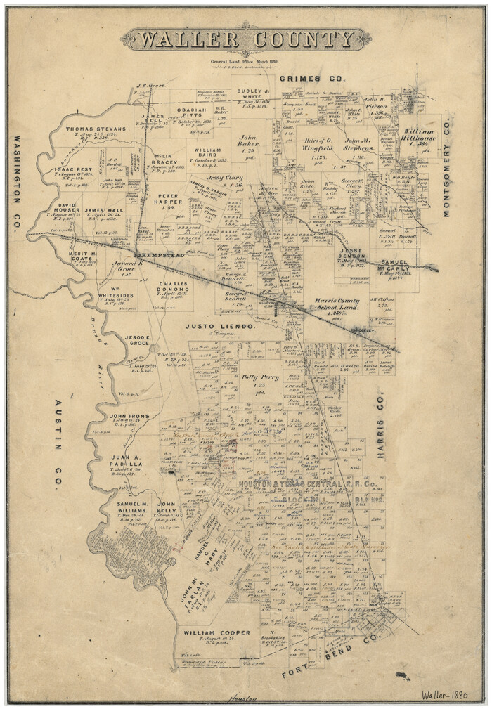
Waller County
Print $20.00
- Digital $50.00
Waller County
1880
-
Size
20.4 x 14.5 inches
-
Map/Doc
4121
-
Creation Date
1880
Harris County Rolled Sketch 28(1)
Print $39.00
- Digital $50.00
Harris County Rolled Sketch 28(1)
-
Size
10.0 x 15.3 inches
-
Map/Doc
45770
Waller County

Print $20.00
- Digital $50.00
Waller County
1879
-
Size
23.8 x 17.0 inches
-
Map/Doc
4640
-
Creation Date
1879
Fort Bend County Rolled Sketch 30 1/2
Print $20.00
- Digital $50.00
Fort Bend County Rolled Sketch 30 1/2
-
Size
20.1 x 26.5 inches
-
Map/Doc
5902
Waller County Boundary File 1
Print $8.00
- Digital $50.00
Waller County Boundary File 1
-
Size
11.4 x 8.9 inches
-
Map/Doc
59663
Harris County Rolled Sketch 28
Print $20.00
- Digital $50.00
Harris County Rolled Sketch 28
-
Size
29.8 x 47.3 inches
-
Map/Doc
6095
Harris County Rolled Sketch 30
Print $20.00
- Digital $50.00
Harris County Rolled Sketch 30
1889
-
Size
30.4 x 35.1 inches
-
Map/Doc
6096
-
Creation Date
1889
Harris County Rolled Sketch 97
Print $20.00
- Digital $50.00
Harris County Rolled Sketch 97
-
Size
18.8 x 23.6 inches
-
Map/Doc
6135