Waller County Boundary File 1
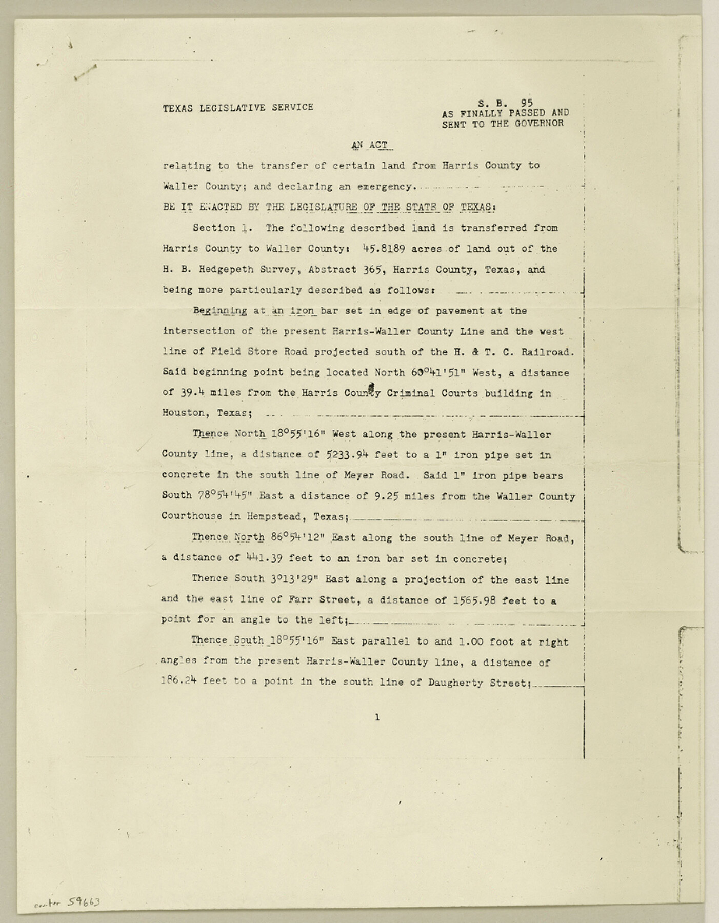
S. B. 95 As Finally Passed and Sent to the Governor relating to the transfer of certain land from Harris County to Waller County
- 
                          Map/Doc59663
- 
                            CollectionGeneral Map Collection
- 
                            CountiesWaller
- 
                            SubjectsCounty Boundaries
- 
                            Height x Width11.4 x 8.9 inches29.0 x 22.6 cm
Part of: General Map Collection
            Intrenched depot of the army of occupation at Point Isabel, Texas


                                            Print $20.00                    
                                             -                         Digital $50.00                                    
                Intrenched depot of the army of occupation at Point Isabel, Texas
1846
Size 17.0 x 25.2 inches
                                Map/Doc 72922
            
            Concho County Sketch File 18


                                            Print $32.00                    
                                             -                         Digital $50.00                                    
                Concho County Sketch File 18
1898
Size 9.1 x 4.4 inches
                                Map/Doc 19137
            
            Winkler County Sketch File 4


                                            Print $8.00                    
                                             -                         Digital $50.00                                    
                Winkler County Sketch File 4
Size 14.3 x 8.8 inches
                                Map/Doc 40463
            
            Uvalde County Rolled Sketch B


                                            Print $20.00                    
                                             -                         Digital $50.00                                    
                Uvalde County Rolled Sketch B
1847
Size 28.8 x 22.4 inches
                                Map/Doc 8105
            
            Flight Mission No. BQR-13K, Frame 117, Brazoria County


                                            Print $20.00                    
                                             -                         Digital $50.00                                    
                Flight Mission No. BQR-13K, Frame 117, Brazoria County
1952
Size 18.6 x 22.4 inches
                                Map/Doc 84078
            
            Red River County Working Sketch 76


                                            Print $20.00                    
                                             -                         Digital $50.00                                    
                Red River County Working Sketch 76
1980
Size 17.7 x 33.9 inches
                                Map/Doc 72059
            
            Flight Mission No. CRC-3R, Frame 96, Chambers County


                                            Print $20.00                    
                                             -                         Digital $50.00                                    
                Flight Mission No. CRC-3R, Frame 96, Chambers County
1956
Size 18.7 x 22.4 inches
                                Map/Doc 84834
            
            Falls County Sketch File 2


                                            Print $4.00                    
                                             -                         Digital $50.00                                    
                Falls County Sketch File 2
1854
Size 13.1 x 8.3 inches
                                Map/Doc 22332
            
            Coke County Rolled Sketch 33


                                            Print $20.00                    
                                             -                         Digital $50.00                                    
                Coke County Rolled Sketch 33
2004
Size 28.9 x 40.5 inches
                                Map/Doc 82987
            
            Jackson County Boundary File 2a


                                            Print $86.00                    
                                             -                         Digital $50.00                                    
                Jackson County Boundary File 2a
Size 14.4 x 8.8 inches
                                Map/Doc 55448
            
            Lubbock County


                                            Print $20.00                    
                                             -                         Digital $50.00                                    
                Lubbock County
1968
Size 44.2 x 35.8 inches
                                Map/Doc 95576
            You may also like
            Pecos County Working Sketch 15


                                            Print $20.00                    
                                             -                         Digital $50.00                                    
                Pecos County Working Sketch 15
1914
Size 29.8 x 15.4 inches
                                Map/Doc 71485
            
            Mills County Sketch File 26


                                            Print $4.00                    
                                             -                         Digital $50.00                                    
                Mills County Sketch File 26
1998
Size 14.3 x 8.8 inches
                                Map/Doc 31678
            
            [School Land Leagues in east part of Bailey County/west part of Lamb County]
            
                                    ![90256, [School Land Leagues in east part of Bailey County/west part of Lamb County], Twichell Survey Records](https://historictexasmaps.com/wmedia_w700/maps/90256-1.tif.jpg) 


    ![90256, [School Land Leagues in east part of Bailey County/west part of Lamb County], Twichell Survey Records](https://historictexasmaps.com/wmedia_w700/maps/90256-1.tif.jpg) 
                                
            
                                            Print $2.00                    
                                             -                         Digital $50.00                                    
                [School Land Leagues in east part of Bailey County/west part of Lamb County]
Size 11.8 x 8.9 inches
                                Map/Doc 90256
            
            Hutchinson County Rolled Sketch 44-14


                                            Print $20.00                    
                                             -                         Digital $50.00                                    
                Hutchinson County Rolled Sketch 44-14
2002
Size 24.0 x 36.0 inches
                                Map/Doc 77550
            
            Presidio County Working Sketch 110


                                            Print $20.00                    
                                             -                         Digital $50.00                                    
                Presidio County Working Sketch 110
1981
Size 38.7 x 32.2 inches
                                Map/Doc 71787
            
            Kimble County Sketch File 17


                                            Print $17.00                    
                                             -                         Digital $50.00                                    
                Kimble County Sketch File 17
Size 11.5 x 8.5 inches
                                Map/Doc 28947
            
            Southern Pacific R.R. and connections


                                            Print $20.00                    
                                             -                         Digital $50.00                                    
                Southern Pacific R.R. and connections
1883
Size 27.9 x 32.5 inches
                                Map/Doc 94270
            
            San Jacinto County Rolled Sketch 5


                                            Print $20.00                    
                                             -                         Digital $50.00                                    
                San Jacinto County Rolled Sketch 5
Size 13.7 x 18.6 inches
                                Map/Doc 8386
            
            Presidio County Rolled Sketch 91


                                            Print $20.00                    
                                             -                         Digital $50.00                                    
                Presidio County Rolled Sketch 91
Size 15.1 x 29.4 inches
                                Map/Doc 7376
            
            United States - Gulf Coast - From Latitude 26° 33' to the Rio Grande Texas


                                            Print $20.00                    
                                             -                         Digital $50.00                                    
                United States - Gulf Coast - From Latitude 26° 33' to the Rio Grande Texas
1913
Size 27.8 x 18.4 inches
                                Map/Doc 72831
            
            Boundaries of Robertson's Colony and of Milam's Colony


                                            Print $6.00                    
                                             -                         Digital $50.00                                    
                Boundaries of Robertson's Colony and of Milam's Colony
1840
Size 9.5 x 14.8 inches
                                Map/Doc 1949
            
            Madison County Working Sketch 7


                                            Print $2.00                    
                                             -                         Digital $50.00                                    
                Madison County Working Sketch 7
1982
Size 12.7 x 17.4 inches
                                Map/Doc 70769
             
                            