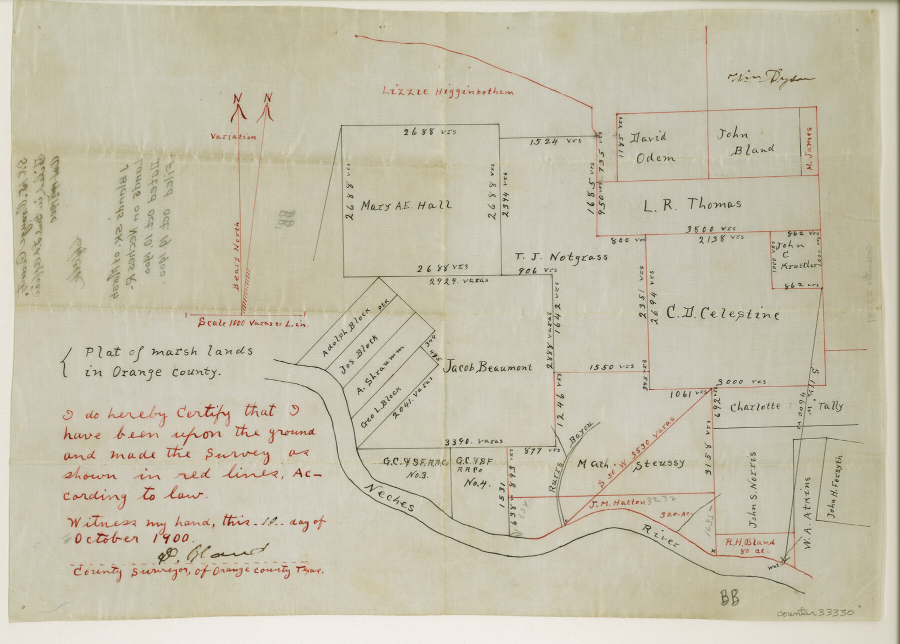
Orange County Sketch File 15
[Plat of marsh lands on the Neches River in Orange County]
-
Map/Doc
33330
-
Collection
General Map Collection
-
Object Dates
10/10/1900 (Creation Date)
10/19/1900 (File Date)
-
People and Organizations
Joseph Bland (Surveyor/Engineer)
-
Counties
Orange
-
Subjects
Surveying Sketch File
-
Height x Width
11.0 x 15.4 inches
27.9 x 39.1 cm
-
Medium
paper, manuscript
-
Scale
1" = 1000 varas
-
Features
Neches River
Part of: General Map Collection
Military Reconnaissance [showing forts along Rio Grande near Matamoros]
![72909, Military Reconnaissance [showing forts along Rio Grande near Matamoros], General Map Collection](https://historictexasmaps.com/wmedia_w700/maps/72909.tif.jpg)
Print $20.00
- Digital $50.00
Military Reconnaissance [showing forts along Rio Grande near Matamoros]
1846
Size 18.2 x 26.3 inches
Map/Doc 72909
Flight Mission No. DQN-5K, Frame 30, Calhoun County

Print $20.00
- Digital $50.00
Flight Mission No. DQN-5K, Frame 30, Calhoun County
1953
Size 16.7 x 16.5 inches
Map/Doc 84381
Controlled Mosaic by Jack Amman Photogrammetric Engineers, Inc - Sheet 57

Print $20.00
- Digital $50.00
Controlled Mosaic by Jack Amman Photogrammetric Engineers, Inc - Sheet 57
1954
Size 20.0 x 24.0 inches
Map/Doc 83516
[Sketch for Mineral Applications 7410, 7411, 7412, 7413, 7712 - Kleberg County]
![65624, [Sketch for Mineral Applications 7410, 7411, 7412, 7413, 7712 - Kleberg County], General Map Collection](https://historictexasmaps.com/wmedia_w700/maps/65624-1.tif.jpg)
Print $40.00
- Digital $50.00
[Sketch for Mineral Applications 7410, 7411, 7412, 7413, 7712 - Kleberg County]
1977
Size 91.9 x 44.5 inches
Map/Doc 65624
Brewster County Rolled Sketch 114

Print $20.00
- Digital $50.00
Brewster County Rolled Sketch 114
1964
Size 11.4 x 17.7 inches
Map/Doc 5284
Armstrong County Sketch File D

Print $40.00
- Digital $50.00
Armstrong County Sketch File D
Size 16.1 x 21.0 inches
Map/Doc 10857
Liberty County Working Sketch 74

Print $20.00
- Digital $50.00
Liberty County Working Sketch 74
1979
Size 38.8 x 35.4 inches
Map/Doc 70534
Upton County Rolled Sketch 48

Print $20.00
- Digital $50.00
Upton County Rolled Sketch 48
1958
Size 27.8 x 27.9 inches
Map/Doc 10694
Grayson County Rolled Sketch 2

Print $20.00
- Digital $50.00
Grayson County Rolled Sketch 2
1951
Size 25.5 x 42.5 inches
Map/Doc 6030
Flight Mission No. BQY-4M, Frame 118, Harris County

Print $20.00
- Digital $50.00
Flight Mission No. BQY-4M, Frame 118, Harris County
1953
Size 18.6 x 22.3 inches
Map/Doc 85285
Matagorda County Working Sketch 3

Print $40.00
- Digital $50.00
Matagorda County Working Sketch 3
1936
Size 43.7 x 48.4 inches
Map/Doc 70861
Flight Mission No. CLL-3N, Frame 12, Willacy County

Print $20.00
- Digital $50.00
Flight Mission No. CLL-3N, Frame 12, Willacy County
1954
Size 18.4 x 22.0 inches
Map/Doc 87078
You may also like
San Patricio County Sketch File 22

Print $20.00
San Patricio County Sketch File 22
1918
Size 22.2 x 16.9 inches
Map/Doc 12285
General Highway Map, Mitchell County, Texas

Print $20.00
General Highway Map, Mitchell County, Texas
1961
Size 18.1 x 24.6 inches
Map/Doc 79600

Morris County Rolled Sketch 2A

Print $20.00
- Digital $50.00
Morris County Rolled Sketch 2A
Size 24.2 x 19.1 inches
Map/Doc 10247
![90772, [Block XR], Twichell Survey Records](https://historictexasmaps.com/wmedia_w700/maps/90772-1.tif.jpg)
Upshur County Working Sketch 12

Print $20.00
- Digital $50.00
Upshur County Working Sketch 12
1984
Size 31.9 x 29.6 inches
Map/Doc 69569
Dimmit County Rolled Sketch M

Print $20.00
- Digital $50.00
Dimmit County Rolled Sketch M
1936
Size 21.5 x 39.3 inches
Map/Doc 5727
Duval County Sketch File 73

Print $4.00
- Digital $50.00
Duval County Sketch File 73
Size 9.9 x 8.8 inches
Map/Doc 21463
Frio County Rolled Sketch HM

Print $20.00
- Digital $50.00
Frio County Rolled Sketch HM
1935
Size 41.2 x 30.6 inches
Map/Doc 8898
Houston County Working Sketch 5

Print $20.00
- Digital $50.00
Houston County Working Sketch 5
Size 24.9 x 28.1 inches
Map/Doc 66235
Maverick County Working Sketch 17

Print $20.00
- Digital $50.00
Maverick County Working Sketch 17
1975
Size 28.8 x 31.4 inches
Map/Doc 70909
Flight Mission No. BRE-1P, Frame 148, Nueces County

Print $20.00
- Digital $50.00
Flight Mission No. BRE-1P, Frame 148, Nueces County
1956
Size 18.6 x 22.7 inches
Map/Doc 86708