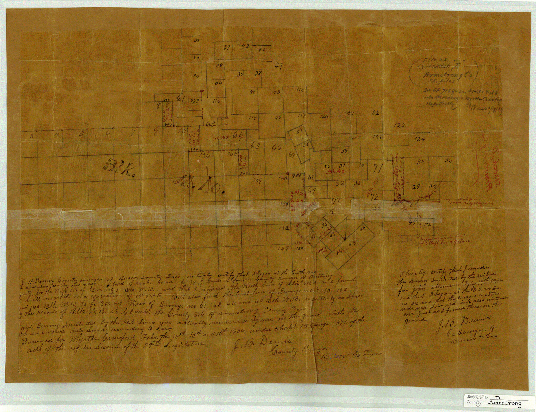
Armstrong County Sketch File D
[Sketch in the vicinity of Block M10 in southwest part of county]
-
Map/Doc
10857
-
Collection
General Map Collection
-
Object Dates
1906/2/16 (Survey Date)
-
People and Organizations
J.B. Dennis (Surveyor/Engineer)
-
Counties
Armstrong
-
Subjects
Surveying Sketch File
-
Height x Width
16.1 x 21.0 inches
40.9 x 53.3 cm
-
Medium
paper, manuscript
-
Features
Wagon Creek
Red River
Part of: General Map Collection
Throckmorton County Rolled Sketch 5A

Print $20.00
- Digital $50.00
Throckmorton County Rolled Sketch 5A
2001
Size 25.2 x 36.0 inches
Map/Doc 76406
Lynn County Sketch File 14

Print $12.00
- Digital $50.00
Lynn County Sketch File 14
1916
Size 14.1 x 8.7 inches
Map/Doc 30491
Bosque County Working Sketch 33

Print $20.00
- Digital $50.00
Bosque County Working Sketch 33
2016
Size 37.0 x 25.0 inches
Map/Doc 93980
Wilbarger County Sketch File 2

Print $4.00
- Digital $50.00
Wilbarger County Sketch File 2
1862
Size 8.9 x 7.9 inches
Map/Doc 40164
Fort Bend County Working Sketch 21

Print $20.00
- Digital $50.00
Fort Bend County Working Sketch 21
Size 26.9 x 28.6 inches
Map/Doc 69227
Flight Mission No. CRC-4R, Frame 66, Chambers County

Print $20.00
- Digital $50.00
Flight Mission No. CRC-4R, Frame 66, Chambers County
1956
Size 18.6 x 22.5 inches
Map/Doc 84870
Current Miscellaneous File 103

Print $4.00
- Digital $50.00
Current Miscellaneous File 103
1840
Size 11.2 x 8.8 inches
Map/Doc 74675
Map of the River Sabine from its mouth on the Gulf of Mexico in the Sea to Logan's Ferry in Latitude 31°58'24" North

Print $20.00
- Digital $50.00
Map of the River Sabine from its mouth on the Gulf of Mexico in the Sea to Logan's Ferry in Latitude 31°58'24" North
1842
Size 47.9 x 30.6 inches
Map/Doc 87150
Flight Mission No. BRE-2P, Frame 42, Nueces County

Print $20.00
- Digital $50.00
Flight Mission No. BRE-2P, Frame 42, Nueces County
1956
Size 18.5 x 22.4 inches
Map/Doc 86744
Geodetic positions of authentic boundary mounds, established by Louisiana Geodetic Survey traverse

Print $4.00
- Digital $50.00
Geodetic positions of authentic boundary mounds, established by Louisiana Geodetic Survey traverse
Size 28.8 x 28.7 inches
Map/Doc 1734
Nolan County Working Sketch 1

Print $20.00
- Digital $50.00
Nolan County Working Sketch 1
1928
Size 17.9 x 17.5 inches
Map/Doc 71292
Andrews County Rolled Sketch 8

Print $40.00
- Digital $50.00
Andrews County Rolled Sketch 8
1928
Size 31.4 x 54.0 inches
Map/Doc 8388
You may also like
General Highway Map, Garza County, Texas

Print $20.00
General Highway Map, Garza County, Texas
1940
Size 18.1 x 24.6 inches
Map/Doc 79098
Menard County Working Sketch 5

Print $20.00
- Digital $50.00
Menard County Working Sketch 5
1921
Size 17.2 x 22.3 inches
Map/Doc 70952
[Sketch showing School Lands]
![90448, [Sketch showing School Lands], Twichell Survey Records](https://historictexasmaps.com/wmedia_w700/maps/90448-1.tif.jpg)
Print $20.00
- Digital $50.00
[Sketch showing School Lands]
Size 16.3 x 12.2 inches
Map/Doc 90448
Pecos County Rolled Sketch 93

Print $40.00
- Digital $50.00
Pecos County Rolled Sketch 93
Size 50.3 x 42.8 inches
Map/Doc 9711
Palo Pinto County Sketch File 28

Print $8.00
- Digital $50.00
Palo Pinto County Sketch File 28
1875
Size 11.3 x 8.6 inches
Map/Doc 33437
Motley County Working Sketch 9

Print $20.00
- Digital $50.00
Motley County Working Sketch 9
1984
Size 32.6 x 28.9 inches
Map/Doc 71214
[Cotton Belt, St. Louis Southwestern Railway of Texas, Alignment through Smith County]
![64386, [Cotton Belt, St. Louis Southwestern Railway of Texas, Alignment through Smith County], General Map Collection](https://historictexasmaps.com/wmedia_w700/maps/64386.tif.jpg)
Print $20.00
- Digital $50.00
[Cotton Belt, St. Louis Southwestern Railway of Texas, Alignment through Smith County]
1903
Size 21.7 x 29.3 inches
Map/Doc 64386
Floyd County Sketch File 12

Print $10.00
- Digital $50.00
Floyd County Sketch File 12
1913
Size 10.8 x 8.8 inches
Map/Doc 22708
Pecos County Rolled Sketch 153

Print $20.00
- Digital $50.00
Pecos County Rolled Sketch 153
1960
Size 20.2 x 22.7 inches
Map/Doc 7282
Andrews County Working Sketch 25

Print $40.00
- Digital $50.00
Andrews County Working Sketch 25
1980
Size 70.6 x 44.0 inches
Map/Doc 67071
Navigation Maps of Gulf Intracoastal Waterway, Port Arthur to Brownsville, Texas

Print $4.00
- Digital $50.00
Navigation Maps of Gulf Intracoastal Waterway, Port Arthur to Brownsville, Texas
1951
Size 16.8 x 21.5 inches
Map/Doc 65437
Sketch from old map (authority unknown) showing a portion of the Rio Grande River and harbor of Brazos Santiago, Texas

Print $20.00
- Digital $50.00
Sketch from old map (authority unknown) showing a portion of the Rio Grande River and harbor of Brazos Santiago, Texas
1887
Size 18.1 x 24.3 inches
Map/Doc 73003