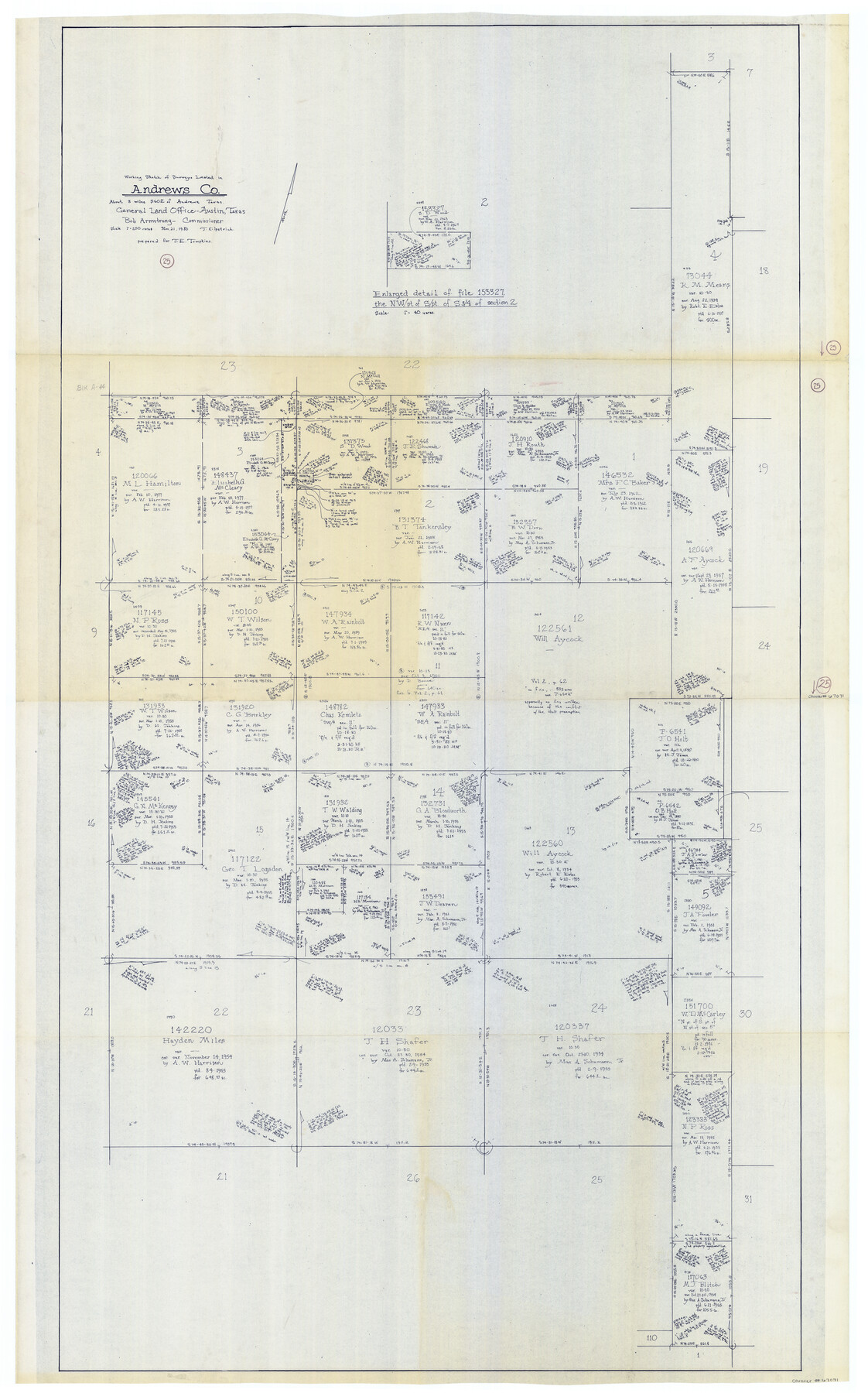
Andrews County Working Sketch 25
-
Map/Doc
67071
-
Collection
General Map Collection
-
Object Dates
11/21/1980 (Creation Date)
-
People and Organizations
Bob Armstrong (GLO Commissioner)
Joan Kilpatrick (Draftsman)
-
Counties
Andrews
-
Subjects
Surveying Working Sketch
-
Height x Width
70.6 x 44.0 inches
179.3 x 111.8 cm
-
Scale
1" = 200 varas
-
Comments
Surveys located about three miles South 60 degrees East of Andrews, Texas.
Part of: General Map Collection

Flight Mission No. DAG-24K, Frame 136, Matagorda County

Print $20.00
- Digital $50.00
Flight Mission No. DAG-24K, Frame 136, Matagorda County
1953
Size 18.4 x 22.2 inches
Map/Doc 86554
San Jacinto County Rolled Sketch 9

Print $20.00
- Digital $50.00
San Jacinto County Rolled Sketch 9
1944
Size 39.9 x 36.8 inches
Map/Doc 9881
Right of Way & Track Map, The Texas & Pacific Ry. Co. Main Line

Print $20.00
- Digital $50.00
Right of Way & Track Map, The Texas & Pacific Ry. Co. Main Line
Size 11.0 x 18.3 inches
Map/Doc 64687
Houston County Rolled Sketch 4

Print $40.00
- Digital $50.00
Houston County Rolled Sketch 4
Size 42.2 x 52.1 inches
Map/Doc 9181
Map of the Territory of the United States from the Mississippi to the Pacific Ocean ordered by the Hon. Jeff'n Davis, Secretary of War to accompany the reports of the explorations for a railroad route

Print $40.00
- Digital $50.00
Map of the Territory of the United States from the Mississippi to the Pacific Ocean ordered by the Hon. Jeff'n Davis, Secretary of War to accompany the reports of the explorations for a railroad route
Size 48.6 x 50.7 inches
Map/Doc 94276
Current Miscellaneous File 82

Print $4.00
- Digital $50.00
Current Miscellaneous File 82
Size 12.0 x 8.8 inches
Map/Doc 74224
Red River County Working Sketch 38

Print $20.00
- Digital $50.00
Red River County Working Sketch 38
1965
Size 24.0 x 24.9 inches
Map/Doc 72021
Travis County Sketch File 11

Print $4.00
- Digital $50.00
Travis County Sketch File 11
1872
Size 11.4 x 8.8 inches
Map/Doc 38300
Dimmit County Rolled Sketch 22A

Print $20.00
- Digital $50.00
Dimmit County Rolled Sketch 22A
2012
Size 23.2 x 34.0 inches
Map/Doc 93630
[South part of Lamar County]
![76045, [South part of Lamar County], General Map Collection](https://historictexasmaps.com/wmedia_w700/maps/76045.tif.jpg)
Print $20.00
- Digital $50.00
[South part of Lamar County]
1844
Size 15.5 x 20.5 inches
Map/Doc 76045
Burnet County Sketch File 30

Print $4.00
- Digital $50.00
Burnet County Sketch File 30
Size 11.0 x 8.0 inches
Map/Doc 16746
You may also like
Sketch D No. 2 Showing the Progress of the Survey of Cape Fear and Vicinity in Sections No. IV & V

Digital $50.00
Sketch D No. 2 Showing the Progress of the Survey of Cape Fear and Vicinity in Sections No. IV & V
1852
Size 12.3 x 10.0 inches
Map/Doc 97209
Sterling County Sketch File 6

Print $12.00
- Digital $50.00
Sterling County Sketch File 6
1912
Size 5.7 x 8.8 inches
Map/Doc 37115
Martha's Vineyard to Block Island Including Western Approach to Cape Cod Canal

Print $20.00
- Digital $50.00
Martha's Vineyard to Block Island Including Western Approach to Cape Cod Canal
1963
Size 37.5 x 45.7 inches
Map/Doc 73554
Matagorda County Rolled Sketch 26

Print $20.00
- Digital $50.00
Matagorda County Rolled Sketch 26
1950
Size 39.5 x 42.1 inches
Map/Doc 9479
Gray County Sketch File 5

Print $16.00
- Digital $50.00
Gray County Sketch File 5
1882
Size 12.8 x 8.3 inches
Map/Doc 24418
[St. Louis & Southwestern]
![64279, [St. Louis & Southwestern], General Map Collection](https://historictexasmaps.com/wmedia_w700/maps/64279.tif.jpg)
Print $20.00
- Digital $50.00
[St. Louis & Southwestern]
Size 20.7 x 28.5 inches
Map/Doc 64279
Donley County Sketch File 22

Print $20.00
- Digital $50.00
Donley County Sketch File 22
Size 20.4 x 28.0 inches
Map/Doc 11368
Marion County Rolled Sketch 1A

Print $15.00
- Digital $50.00
Marion County Rolled Sketch 1A
1954
Size 9.9 x 15.2 inches
Map/Doc 46610
Jim Hogg County Working Sketch Graphic Index

Print $20.00
- Digital $50.00
Jim Hogg County Working Sketch Graphic Index
1962
Size 40.0 x 28.7 inches
Map/Doc 76596
Limestone County Sketch File 10a

Print $22.00
- Digital $50.00
Limestone County Sketch File 10a
Size 12.5 x 15.8 inches
Map/Doc 30173
Comanche County Working Sketch 4

Print $40.00
- Digital $50.00
Comanche County Working Sketch 4
1919
Size 58.7 x 35.2 inches
Map/Doc 68138
Coke County Sketch File 30

Print $40.00
- Digital $50.00
Coke County Sketch File 30
Size 12.2 x 17.6 inches
Map/Doc 18641