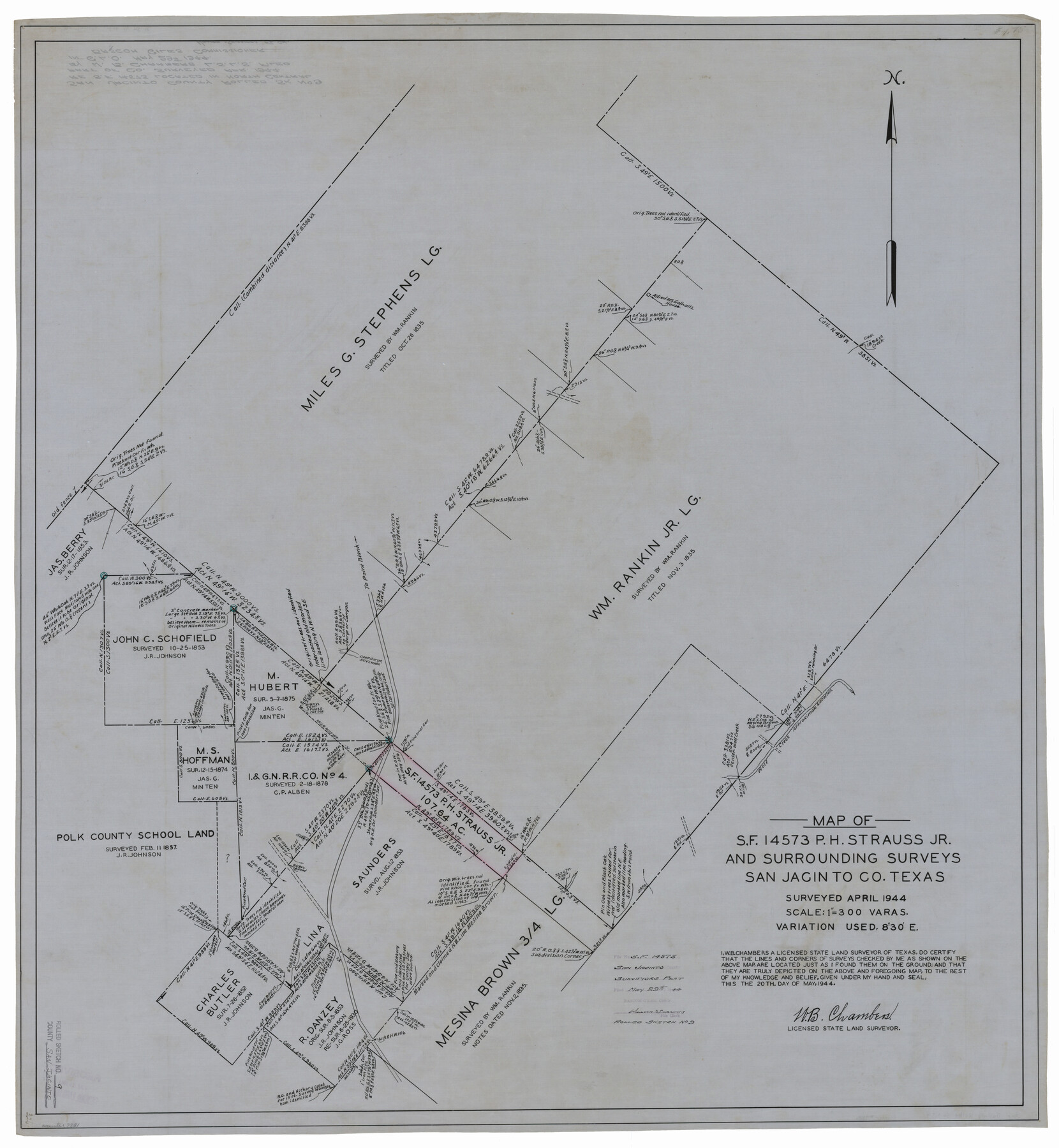
San Jacinto County Rolled Sketch 9
Map of SF-14573 P.H. Strauss, Jr. and surrounding surveys, San Jacinto Co., Texas
-
Map/Doc
9881
-
Collection
General Map Collection
-
Object Dates
1944 (Survey Date)
1944/5/29 (File Date)
1944/5/20 (Creation Date)
-
People and Organizations
W.B. Chambers (Surveyor/Engineer)
-
Counties
San Jacinto
-
Subjects
Surveying Rolled Sketch
-
Height x Width
39.9 x 36.8 inches
101.3 x 93.5 cm
-
Medium
linen, manuscript
-
Scale
1" = 300 varas
Part of: General Map Collection
Brown County Sketch File 32

Print $84.00
- Digital $50.00
Brown County Sketch File 32
2018
Size 11.0 x 8.5 inches
Map/Doc 95206
Orange County Sketch File 4

Print $34.00
- Digital $50.00
Orange County Sketch File 4
1852
Size 8.2 x 7.7 inches
Map/Doc 33301
Bowie County Sketch File 6a

Print $8.00
- Digital $50.00
Bowie County Sketch File 6a
1927
Size 10.6 x 8.6 inches
Map/Doc 14844
Crockett County Working Sketch 74

Print $20.00
- Digital $50.00
Crockett County Working Sketch 74
1964
Size 29.4 x 22.1 inches
Map/Doc 68407

Flight Mission No. CLL-4N, Frame 35, Willacy County

Print $20.00
- Digital $50.00
Flight Mission No. CLL-4N, Frame 35, Willacy County
1954
Size 18.3 x 22.0 inches
Map/Doc 87108
San Jacinto County Sketch File 17

Print $40.00
San Jacinto County Sketch File 17
1934
Size 60.1 x 26.3 inches
Map/Doc 10598
Blanco County Sketch File 45

Print $4.00
- Digital $50.00
Blanco County Sketch File 45
1934
Size 7.8 x 7.6 inches
Map/Doc 14671
Crockett County Sketch File 35d

Print $10.00
- Digital $50.00
Crockett County Sketch File 35d
Size 14.2 x 8.9 inches
Map/Doc 19750
Brazos Santiago, Texas

Print $20.00
- Digital $50.00
Brazos Santiago, Texas
1882
Size 18.3 x 26.1 inches
Map/Doc 72987
Territorios de Sierragorda e Isla del Carmen

Print $20.00
- Digital $50.00
Territorios de Sierragorda e Isla del Carmen
Size 22.9 x 31.2 inches
Map/Doc 97011
Presidio County Rolled Sketch 3B

Print $20.00
- Digital $50.00
Presidio County Rolled Sketch 3B
Size 26.2 x 24.1 inches
Map/Doc 7328
You may also like
English Field Notes of the Spanish Archives - Book S

English Field Notes of the Spanish Archives - Book S
1835
Map/Doc 96543
Orange County Boundary File 1

Print $4.00
- Digital $50.00
Orange County Boundary File 1
Size 9.7 x 6.3 inches
Map/Doc 57773
[Block O1, Godair]
![90565, [Block O1, Godair], Twichell Survey Records](https://historictexasmaps.com/wmedia_w700/maps/90565-1.tif.jpg)
Print $20.00
- Digital $50.00
[Block O1, Godair]
Size 22.6 x 17.7 inches
Map/Doc 90565
Kinney County Working Sketch 30

Print $40.00
- Digital $50.00
Kinney County Working Sketch 30
1959
Size 52.6 x 34.7 inches
Map/Doc 70212
Freestone County Working Sketch 10

Print $20.00
- Digital $50.00
Freestone County Working Sketch 10
1978
Size 40.6 x 33.1 inches
Map/Doc 69252
Goliad County Sketch File Y

Print $20.00
- Digital $50.00
Goliad County Sketch File Y
1894
Size 14.1 x 12.1 inches
Map/Doc 11574
Schleicher County Sketch File 24a

Print $20.00
- Digital $50.00
Schleicher County Sketch File 24a
Size 16.1 x 16.4 inches
Map/Doc 12303
Plat of Fee Land Adjoining the Town of Lovington, New Mexico

Print $20.00
- Digital $50.00
Plat of Fee Land Adjoining the Town of Lovington, New Mexico
Size 24.2 x 18.4 inches
Map/Doc 92422
Blanco County Working Sketch 7

Print $20.00
- Digital $50.00
Blanco County Working Sketch 7
1924
Size 12.9 x 12.1 inches
Map/Doc 67367
Red River County Working Sketch 71

Print $20.00
- Digital $50.00
Red River County Working Sketch 71
1977
Size 17.8 x 28.0 inches
Map/Doc 72054
Leagues 35, 36, 37, 38, 39, 40, 41, and 42]
![92236, Leagues 35, 36, 37, 38, 39, 40, 41, and 42], Twichell Survey Records](https://historictexasmaps.com/wmedia_w700/maps/92236-1.tif.jpg)
Print $20.00
- Digital $50.00
Leagues 35, 36, 37, 38, 39, 40, 41, and 42]
Size 40.4 x 34.4 inches
Map/Doc 92236
Culberson County Working Sketch 41

Print $20.00
- Digital $50.00
Culberson County Working Sketch 41
1970
Size 22.9 x 42.6 inches
Map/Doc 68495