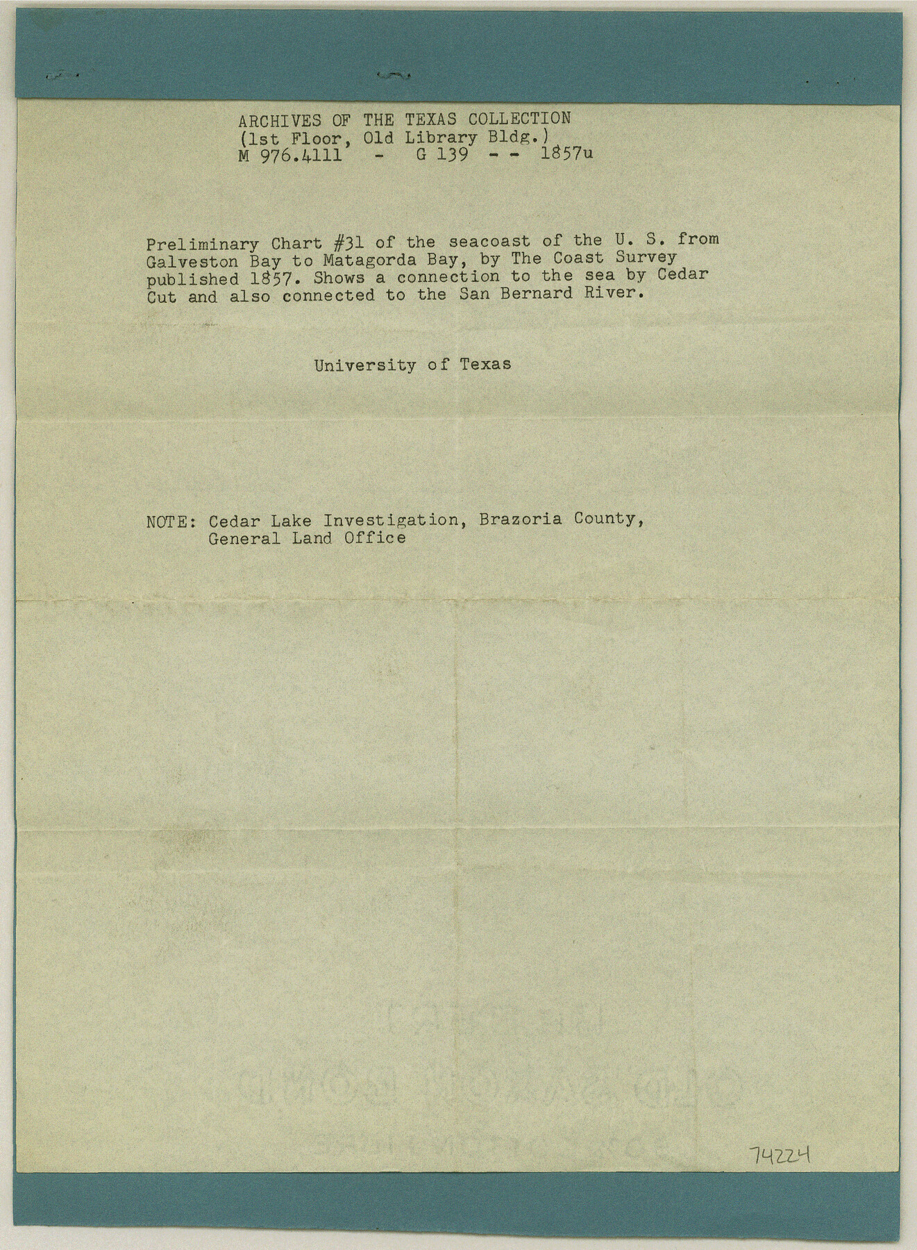
Current Miscellaneous File 82
Reference regarding Cedar Lake investigation, Brazoria County
- 
                          Map/Doc74224
- 
                            CollectionGeneral Map Collection
- 
                            Object Dates1960/8/5 (File Date)
- 
                            SubjectsCuriosities
- 
                            Height x Width12.0 x 8.8 inches30.5 x 22.4 cm
Part of: General Map Collection
            Val Verde County Sketch File 8


                                            Print $38.00                    
                                             -                         Digital $50.00                                    
                Val Verde County Sketch File 8
1885
Size 22.6 x 23.2 inches
                                Map/Doc 12564
            
            Duval County Sketch File 35b


                                            Print $6.00                    
                                             -                         Digital $50.00                                    
                Duval County Sketch File 35b
1935
Size 14.4 x 8.8 inches
                                Map/Doc 21374
            
            Aransas County Rolled Sketch 2


                                            Print $20.00                    
                                             -                         Digital $50.00                                    
                Aransas County Rolled Sketch 2
1950
Size 21.4 x 24.4 inches
                                Map/Doc 73615
            
            Flight Mission No. DQN-7K, Frame 31, Calhoun County


                                            Print $20.00                    
                                             -                         Digital $50.00                                    
                Flight Mission No. DQN-7K, Frame 31, Calhoun County
1953
Size 18.5 x 22.1 inches
                                Map/Doc 84469
            
            Lee County Rolled Sketch 2


                                            Print $20.00                    
                                             -                         Digital $50.00                                    
                Lee County Rolled Sketch 2
1976
Size 25.9 x 34.4 inches
                                Map/Doc 6593
            
            Blanco County Working Sketch 6


                                            Print $20.00                    
                                             -                         Digital $50.00                                    
                Blanco County Working Sketch 6
1923
Size 17.6 x 12.5 inches
                                Map/Doc 67365
            
            Irion County Working Sketch 7


                                            Print $20.00                    
                                             -                         Digital $50.00                                    
                Irion County Working Sketch 7
1936
Size 14.4 x 42.7 inches
                                Map/Doc 66416
            
            Upton County Sketch File 6


                                            Print $10.00                    
                                             -                         Digital $50.00                                    
                Upton County Sketch File 6
1909
Size 11.3 x 8.6 inches
                                Map/Doc 38815
            
            Sketch of surveys on Deer Creek, Milam District


                                            Print $2.00                    
                                             -                         Digital $50.00                                    
                Sketch of surveys on Deer Creek, Milam District
1846
Size 7.8 x 10.9 inches
                                Map/Doc 76046
            
            [Plat and field notes of 3.107 acre tract for Clement Cove Harbor Company]
            
                                    ![60397, [Plat and field notes of 3.107 acre tract for Clement Cove Harbor Company], General Map Collection](https://historictexasmaps.com/wmedia_w700/maps/60397-1.tif.jpg) 


    ![60397, [Plat and field notes of 3.107 acre tract for Clement Cove Harbor Company], General Map Collection](https://historictexasmaps.com/wmedia_w700/maps/60397-1.tif.jpg) 
                                
            
                                            Print $20.00                    
                                             -                         Digital $50.00                                    
                [Plat and field notes of 3.107 acre tract for Clement Cove Harbor Company]
1987
Size 24.2 x 36.5 inches
                                Map/Doc 60397
            
            Hale County Sketch File 6


                                            Print $20.00                    
                                             -                         Digital $50.00                                    
                Hale County Sketch File 6
Size 41.9 x 35.5 inches
                                Map/Doc 10468
            
            Map of the Paluxy Artesian Reservoirs of the Black and Grand Prairies of Texas including the Eastern and Western Cross Timbers


                                            Print $20.00                    
                                             -                         Digital $50.00                                    
                Map of the Paluxy Artesian Reservoirs of the Black and Grand Prairies of Texas including the Eastern and Western Cross Timbers
1900
Size 24.8 x 24.4 inches
                                Map/Doc 75919
            You may also like
            Upton County Working Sketch 8


                                            Print $20.00                    
                                             -                         Digital $50.00                                    
                Upton County Working Sketch 8
1916
Size 21.9 x 16.8 inches
                                Map/Doc 69504
            
            [Leagues 589-598, 627-630, part of Black Water Pasture]
            
                                    ![90259, [Leagues 589-598, 627-630, part of Black Water Pasture], Twichell Survey Records](https://historictexasmaps.com/wmedia_w700/maps/90259-1.tif.jpg) 


    ![90259, [Leagues 589-598, 627-630, part of Black Water Pasture], Twichell Survey Records](https://historictexasmaps.com/wmedia_w700/maps/90259-1.tif.jpg) 
                                
            
                                            Print $3.00                    
                                             -                         Digital $50.00                                    
                [Leagues 589-598, 627-630, part of Black Water Pasture]
Size 14.5 x 11.5 inches
                                Map/Doc 90259
            
            Reagan County Rolled Sketch 27


                                            Print $40.00                    
                                             -                         Digital $50.00                                    
                Reagan County Rolled Sketch 27
Size 66.0 x 47.2 inches
                                Map/Doc 9821
            
            Crane County Sketch File 19


                                            Print $4.00                    
                                             -                         Digital $50.00                                    
                Crane County Sketch File 19
1927
Size 11.4 x 8.8 inches
                                Map/Doc 19584
            
            Padre Island National Seashore


                                            Print $4.00                    
                                             -                         Digital $50.00                                    
                Padre Island National Seashore
Size 16.0 x 22.0 inches
                                Map/Doc 60529
            
            Bell County Sketch File 5


                                            Print $4.00                    
                                             -                         Digital $50.00                                    
                Bell County Sketch File 5
1849
Size 12.9 x 8.5 inches
                                Map/Doc 14371
            
            Falls County Working Sketch 2


                                            Print $20.00                    
                                             -                         Digital $50.00                                    
                Falls County Working Sketch 2
1922
Size 19.0 x 30.0 inches
                                Map/Doc 69177
            
            [Blocks W and Z with tie lines]
            
                                    ![90451, [Blocks W and Z with tie lines], Twichell Survey Records](https://historictexasmaps.com/wmedia_w700/maps/90451-1.tif.jpg) 


    ![90451, [Blocks W and Z with tie lines], Twichell Survey Records](https://historictexasmaps.com/wmedia_w700/maps/90451-1.tif.jpg) 
                                
            
                                            Print $20.00                    
                                             -                         Digital $50.00                                    
                [Blocks W and Z with tie lines]
1949
Size 14.4 x 14.2 inches
                                Map/Doc 90451
            
            Freestone County Working Sketch 31a


                                            Print $20.00                    
                                             -                         Digital $50.00                                    
                Freestone County Working Sketch 31a
1996
Size 25.4 x 31.9 inches
                                Map/Doc 69273
            
            The Republic County of Bowie. December 29, 1845


                                            Print $20.00                    
                                    
                The Republic County of Bowie. December 29, 1845
2020
Size 19.5 x 21.7 inches
                                Map/Doc 96108
            
            General Highway Map, Karnes County, Texas


                                            Print $20.00                    
                                    
                General Highway Map, Karnes County, Texas
1940
Size 18.3 x 24.7 inches
                                Map/Doc 79151
             
                            