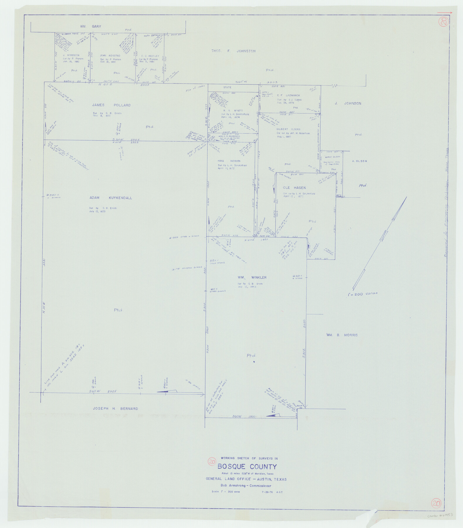
Bosque County Working Sketch 20
-
Map/Doc
67453
-
Collection
General Map Collection
-
Object Dates
7/28/1976 (Creation Date)
-
People and Organizations
Bob Armstrong (GLO Commissioner)
Abner G. Trigg (Draftsman)
-
Counties
Bosque
-
Subjects
Surveying Working Sketch
-
Height x Width
37.4 x 32.8 inches
95.0 x 83.3 cm
-
Scale
1" = 200 varas
-
Comments
Surveys located about 13 miles South 28 degrees West of Meridian, Texas.
Part of: General Map Collection
Rusk County Working Sketch 24

Print $20.00
- Digital $50.00
Rusk County Working Sketch 24
1949
Size 20.2 x 24.7 inches
Map/Doc 63660
Matagorda County Boundary File 1

Print $10.00
- Digital $50.00
Matagorda County Boundary File 1
Size 14.1 x 8.6 inches
Map/Doc 56884

Real County Rolled Sketch 18

Print $20.00
- Digital $50.00
Real County Rolled Sketch 18
Size 22.2 x 28.2 inches
Map/Doc 7461
Pecos County Rolled Sketch 175

Print $20.00
- Digital $50.00
Pecos County Rolled Sketch 175
Size 21.2 x 26.2 inches
Map/Doc 7295
San Patricio County Rolled Sketch 27B

Print $40.00
- Digital $50.00
San Patricio County Rolled Sketch 27B
Size 50.3 x 38.4 inches
Map/Doc 9892
Newton County Working Sketch 25

Print $20.00
- Digital $50.00
Newton County Working Sketch 25
1953
Size 25.4 x 23.8 inches
Map/Doc 71271
Kuechler's Corners, Texas & Pacific Ry. Co. 80 Mile Reserve

Print $703.00
- Digital $50.00
Kuechler's Corners, Texas & Pacific Ry. Co. 80 Mile Reserve
1934
Size 11.0 x 8.5 inches
Map/Doc 2248
Cass County Sketch File 24

Print $16.00
- Digital $50.00
Cass County Sketch File 24
1936
Size 13.9 x 8.7 inches
Map/Doc 17436
Mills County Rolled Sketch 7

Print $20.00
- Digital $50.00
Mills County Rolled Sketch 7
2025
Size 23.7 x 29.8 inches
Map/Doc 97434
Texas Exhibit No. 84 - [Texas and Oklahoma Red River Boundary]
![75261, Texas Exhibit No. 84 - [Texas and Oklahoma Red River Boundary], General Map Collection](https://historictexasmaps.com/wmedia_w700/maps/75261.tif.jpg)
Print $40.00
- Digital $50.00
Texas Exhibit No. 84 - [Texas and Oklahoma Red River Boundary]
1921
Size 35.6 x 52.3 inches
Map/Doc 75261
Medina County Working Sketch 6

Print $20.00
- Digital $50.00
Medina County Working Sketch 6
1950
Size 20.7 x 21.3 inches
Map/Doc 70921
You may also like
Reeves County Working Sketch 49

Print $20.00
- Digital $50.00
Reeves County Working Sketch 49
1974
Size 46.4 x 32.4 inches
Map/Doc 63492
"G" Sketch from Gaines County

Print $20.00
- Digital $50.00
"G" Sketch from Gaines County
1902
Size 31.6 x 21.8 inches
Map/Doc 90845
Colorado County Working Sketch 8

Print $20.00
- Digital $50.00
Colorado County Working Sketch 8
1937
Size 19.7 x 21.0 inches
Map/Doc 68108
Uvalde County Sketch File 9

Print $4.00
- Digital $50.00
Uvalde County Sketch File 9
Size 6.8 x 8.8 inches
Map/Doc 38967
Jeff Davis County Working Sketch 41

Print $20.00
- Digital $50.00
Jeff Davis County Working Sketch 41
1981
Size 26.4 x 34.9 inches
Map/Doc 66536
Falls County Sketch File 22

Print $10.00
- Digital $50.00
Falls County Sketch File 22
1921
Size 8.3 x 5.4 inches
Map/Doc 22423
Dimmit County Rolled Sketch 5

Print $20.00
- Digital $50.00
Dimmit County Rolled Sketch 5
1904
Size 42.7 x 18.2 inches
Map/Doc 5715
Wise County Working Sketch 17

Print $20.00
- Digital $50.00
Wise County Working Sketch 17
1972
Size 29.9 x 25.0 inches
Map/Doc 72631
Hall County Sketch File 32

Print $14.00
- Digital $50.00
Hall County Sketch File 32
1911
Size 11.2 x 8.8 inches
Map/Doc 24839
Knox County Sketch File 20

Print $20.00
- Digital $50.00
Knox County Sketch File 20
1917
Size 26.2 x 17.6 inches
Map/Doc 11962
Webb County Rolled Sketch 15

Print $20.00
- Digital $50.00
Webb County Rolled Sketch 15
Size 25.1 x 15.1 inches
Map/Doc 8179
Tarrant County Sketch File 31

Print $20.00
- Digital $50.00
Tarrant County Sketch File 31
Size 27.2 x 39.3 inches
Map/Doc 10380