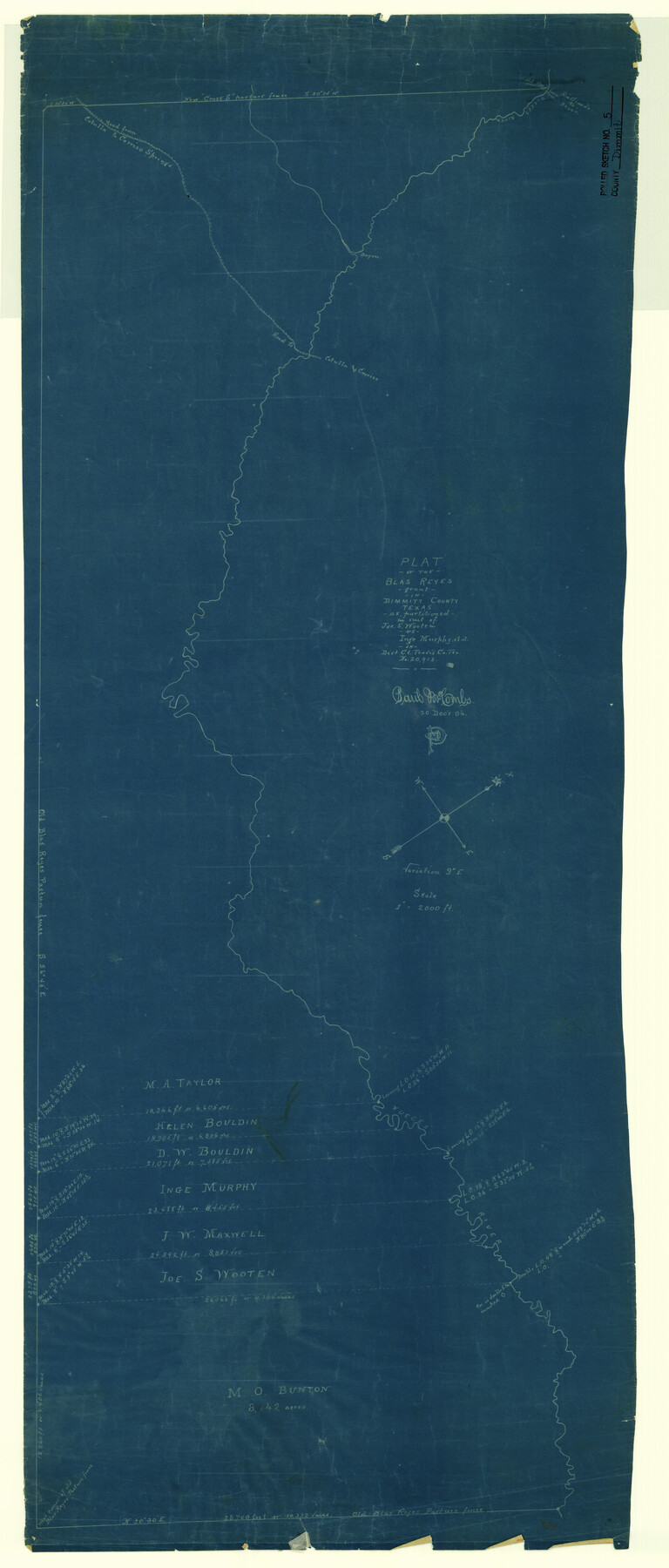
Dimmit County Rolled Sketch 5
Plat of the Blas Reyes grant in Dimmit County, Texas as partitioned in suit of Joe S. Wooten vs. Inge Murphy et al in Dist. Ct. Travis Co., Tex. No. 20913
-
Map/Doc
5715
-
Collection
General Map Collection
-
Object Dates
1904/12/20 (Creation Date)
-
People and Organizations
Paul McCombs (Surveyor/Engineer)
-
Counties
Dimmit
-
Subjects
Surveying Rolled Sketch
-
Height x Width
42.7 x 18.2 inches
108.5 x 46.2 cm
-
Medium
blueprint/diazo
-
Scale
1" = 2000 feet
Part of: General Map Collection
Map of Jack County

Print $20.00
- Digital $50.00
Map of Jack County
Size 18.7 x 15.9 inches
Map/Doc 3703
Presidio County Working Sketch 29

Print $20.00
- Digital $50.00
Presidio County Working Sketch 29
1946
Size 40.0 x 36.6 inches
Map/Doc 71705
Colorado County

Print $20.00
- Digital $50.00
Colorado County
1847
Size 23.7 x 31.4 inches
Map/Doc 3424
McLennan County Sketch File 16

Print $4.00
- Digital $50.00
McLennan County Sketch File 16
1873
Size 12.7 x 8.2 inches
Map/Doc 31276
Liberty County Rolled Sketch K

Print $40.00
- Digital $50.00
Liberty County Rolled Sketch K
1946
Size 35.3 x 54.7 inches
Map/Doc 10647
Upton County Sketch File 28

Print $5.00
- Digital $50.00
Upton County Sketch File 28
1929
Size 22.8 x 31.8 inches
Map/Doc 12521

Map of Texas Gulf Coast and Texas Continental Shelf showing Natural Gas Pipe Lines

Print $40.00
- Digital $50.00
Map of Texas Gulf Coast and Texas Continental Shelf showing Natural Gas Pipe Lines
1968
Size 39.4 x 57.1 inches
Map/Doc 75903
Brewster County Rolled Sketch 59

Print $20.00
- Digital $50.00
Brewster County Rolled Sketch 59
1938
Size 32.8 x 45.2 inches
Map/Doc 8483
Grayson County Working Sketch 18

Print $20.00
- Digital $50.00
Grayson County Working Sketch 18
1955
Size 22.8 x 21.1 inches
Map/Doc 63257
Flight Mission No. CRC-2R, Frame 111, Chambers County

Print $20.00
- Digital $50.00
Flight Mission No. CRC-2R, Frame 111, Chambers County
1956
Size 18.4 x 22.3 inches
Map/Doc 84738

You may also like
Coryell County Working Sketch 6

Print $20.00
- Digital $50.00
Coryell County Working Sketch 6
1941
Size 15.9 x 13.6 inches
Map/Doc 68213

Map of Mason County

Print $20.00
- Digital $50.00
Map of Mason County
1877
Size 25.3 x 19.9 inches
Map/Doc 3836
Hudspeth County Working Sketch 20

Print $40.00
- Digital $50.00
Hudspeth County Working Sketch 20
1966
Size 43.8 x 63.6 inches
Map/Doc 66302
Brewster County Sketch File B-1

Print $6.00
- Digital $50.00
Brewster County Sketch File B-1
1910
Size 14.2 x 8.8 inches
Map/Doc 15716
Fractional Township No. 10 South Range No. 25 East of the Indian Meridian, Indian Territory

Print $20.00
- Digital $50.00
Fractional Township No. 10 South Range No. 25 East of the Indian Meridian, Indian Territory
1898
Size 19.2 x 24.3 inches
Map/Doc 75244
Wood County Boundary File 2a

Print $6.00
- Digital $50.00
Wood County Boundary File 2a
Size 10.0 x 8.0 inches
Map/Doc 60159
[Plat and field notes of 3.107 acre tract for Clement Cove Harbor Company]
![60397, [Plat and field notes of 3.107 acre tract for Clement Cove Harbor Company], General Map Collection](https://historictexasmaps.com/wmedia_w700/maps/60397-1.tif.jpg)
Print $20.00
- Digital $50.00
[Plat and field notes of 3.107 acre tract for Clement Cove Harbor Company]
1987
Size 24.2 x 36.5 inches
Map/Doc 60397
Map of Marion County

Print $20.00
- Digital $50.00
Map of Marion County
1920
Size 29.2 x 43.2 inches
Map/Doc 66916
Harbor Pass and Bar at Brazos Santiago, Texas

Print $20.00
- Digital $50.00
Harbor Pass and Bar at Brazos Santiago, Texas
1879
Size 18.1 x 27.4 inches
Map/Doc 73002
Map of the Roman Empire to illustrate Ancient History, engraved for Olney's school atlas

Print $20.00
- Digital $50.00
Map of the Roman Empire to illustrate Ancient History, engraved for Olney's school atlas
1845
Size 12.1 x 19.0 inches
Map/Doc 93550
Parker County Working Sketch 19-2

Print $20.00
- Digital $50.00
Parker County Working Sketch 19-2
2005
Map/Doc 83580