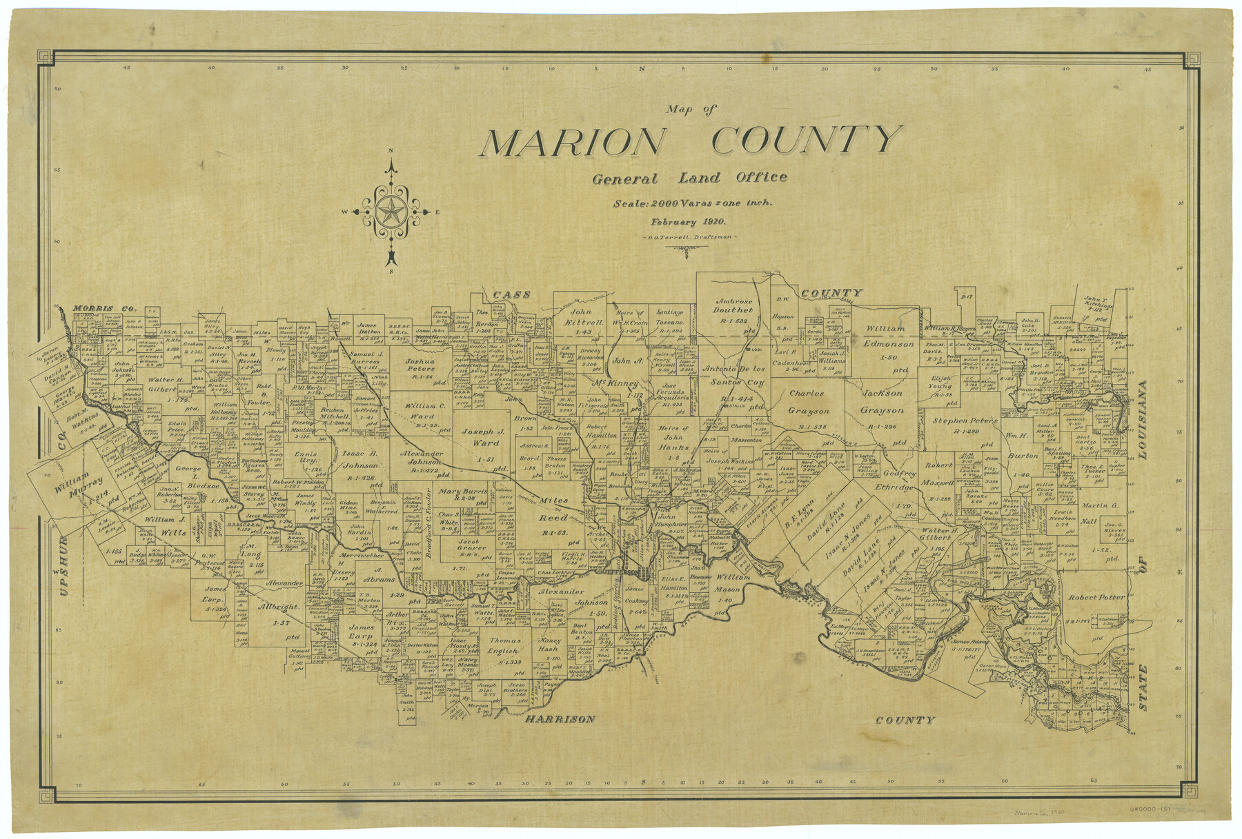
Map of Marion County
-
Map/Doc
66916
-
Collection
General Map Collection
-
Object Dates
1920 (Creation Date)
-
People and Organizations
Texas General Land Office (Publisher)
O.O. Terrell (Draftsman)
O.O. Terrell (Compiler)
-
Counties
Marion
-
Subjects
County
-
Height x Width
29.2 x 43.2 inches
74.2 x 109.7 cm
Part of: General Map Collection

Young County Sketch File 10c

Print $4.00
- Digital $50.00
Young County Sketch File 10c
1878
Size 8.2 x 15.4 inches
Map/Doc 40872
Flight Mission No. BQR-5K, Frame 70, Brazoria County

Print $20.00
- Digital $50.00
Flight Mission No. BQR-5K, Frame 70, Brazoria County
1952
Size 18.8 x 22.4 inches
Map/Doc 84015
Hays County Boundary File 1

Print $14.00
- Digital $50.00
Hays County Boundary File 1
Size 9.5 x 5.2 inches
Map/Doc 54586
Smith County Sketch File 6

Print $4.00
- Digital $50.00
Smith County Sketch File 6
1848
Size 7.2 x 8.6 inches
Map/Doc 36757
Morris County Rolled Sketch 2A

Print $20.00
- Digital $50.00
Morris County Rolled Sketch 2A
Size 22.7 x 17.7 inches
Map/Doc 10227
Bandera County Sketch File 8

Print $6.00
- Digital $50.00
Bandera County Sketch File 8
1878
Size 13.0 x 11.8 inches
Map/Doc 14007
Pecos County Sketch File 96

Print $40.00
- Digital $50.00
Pecos County Sketch File 96
1957
Size 22.4 x 8.7 inches
Map/Doc 33998
Flight Mission No. DIX-10P, Frame 144, Aransas County

Print $20.00
- Digital $50.00
Flight Mission No. DIX-10P, Frame 144, Aransas County
1956
Size 18.6 x 22.3 inches
Map/Doc 83946
[Sketch for Mineral Application 12206 - Cow Bayou, O. B. Sawyer]
![65567, [Sketch for Mineral Application 12206 - Cow Bayou, O. B. Sawyer], General Map Collection](https://historictexasmaps.com/wmedia_w700/maps/65567.tif.jpg)
Print $40.00
- Digital $50.00
[Sketch for Mineral Application 12206 - Cow Bayou, O. B. Sawyer]
Size 140.6 x 37.5 inches
Map/Doc 65567
La Salle County Sketch File 38

Print $40.00
- Digital $50.00
La Salle County Sketch File 38
Size 13.7 x 14.5 inches
Map/Doc 29590
Montgomery County Rolled Sketch 19A

Print $40.00
- Digital $50.00
Montgomery County Rolled Sketch 19A
1933
Size 52.9 x 37.3 inches
Map/Doc 8349
You may also like
Flight Mission No. CGI-4N, Frame 177, Cameron County

Print $20.00
- Digital $50.00
Flight Mission No. CGI-4N, Frame 177, Cameron County
1955
Size 18.5 x 22.2 inches
Map/Doc 84680
Erath County Working Sketch 41

Print $20.00
- Digital $50.00
Erath County Working Sketch 41
Size 25.5 x 29.0 inches
Map/Doc 69122
Working Sketch in Moore County

Print $3.00
- Digital $50.00
Working Sketch in Moore County
1910
Size 15.0 x 10.0 inches
Map/Doc 91537
Comanche County Sketch File 22b

Print $40.00
- Digital $50.00
Comanche County Sketch File 22b
1872
Size 12.1 x 14.8 inches
Map/Doc 19109
Burleson County Working Sketch 42

Print $20.00
- Digital $50.00
Burleson County Working Sketch 42
1953
Size 41.6 x 33.6 inches
Map/Doc 67761
Flight Mission No. CLL-1N, Frame 189, Willacy County

Print $20.00
- Digital $50.00
Flight Mission No. CLL-1N, Frame 189, Willacy County
1954
Size 18.2 x 22.0 inches
Map/Doc 87059
Comanche County Sketch File 18

Print $4.00
- Digital $50.00
Comanche County Sketch File 18
Size 8.4 x 7.8 inches
Map/Doc 19091
Map of San Jacinto County, Texas

Print $20.00
- Digital $50.00
Map of San Jacinto County, Texas
1882
Size 29.7 x 22.8 inches
Map/Doc 610
Polk County Rolled Sketch 27

Print $20.00
- Digital $50.00
Polk County Rolled Sketch 27
1944
Size 21.1 x 26.6 inches
Map/Doc 7315
Bird's Eye View of Cuero, De Witt County, Texas

Print $20.00
Bird's Eye View of Cuero, De Witt County, Texas
1881
Size 18.4 x 25.5 inches
Map/Doc 89079
Dimmit County Sketch File 5

Print $42.00
- Digital $50.00
Dimmit County Sketch File 5
1849
Size 8.6 x 8.0 inches
Map/Doc 21064
Travis County Sketch File 30

Print $6.00
- Digital $50.00
Travis County Sketch File 30
1884
Size 17.0 x 11.0 inches
Map/Doc 38343