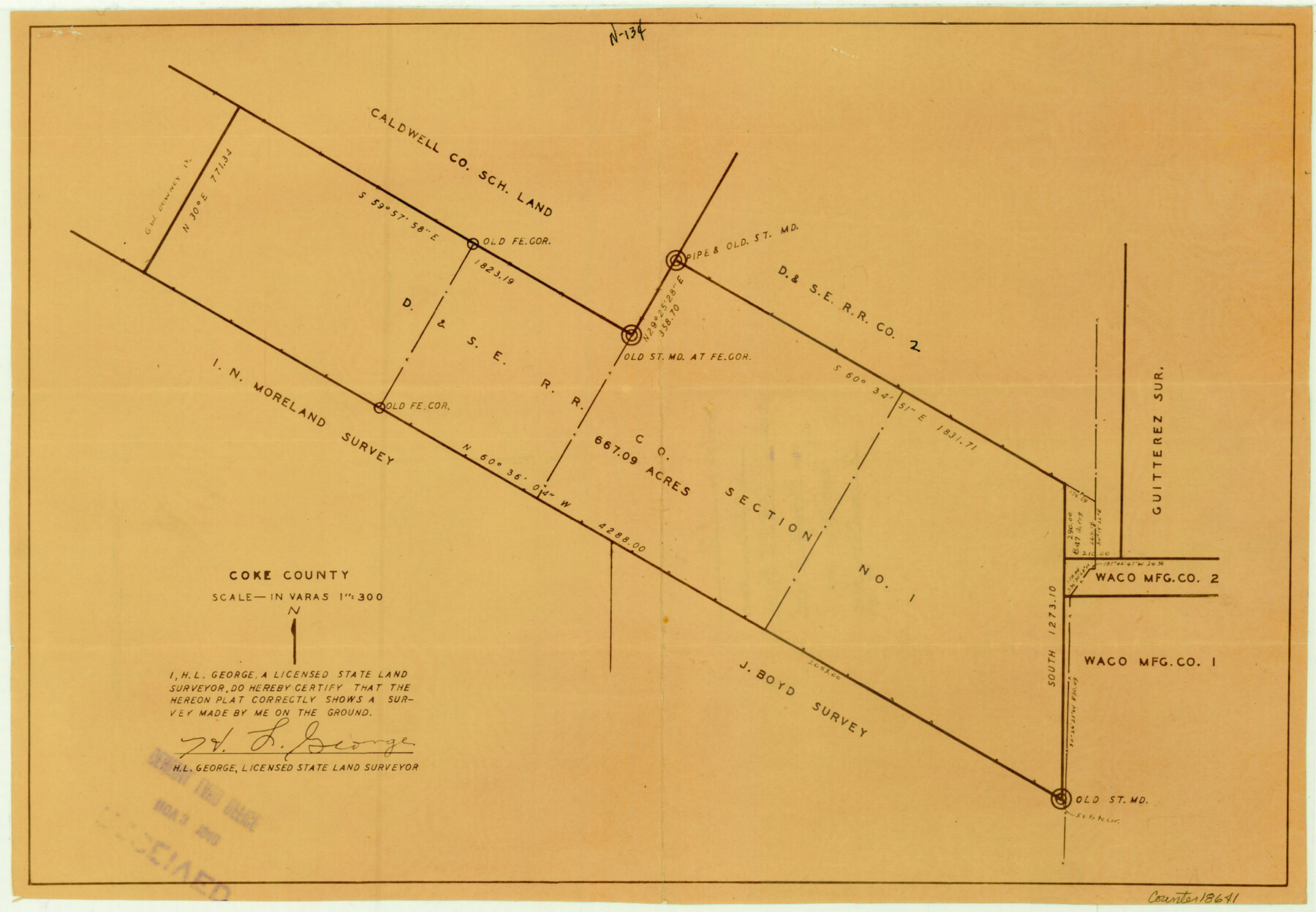
Coke County Sketch File 30
[Sketch of D. & S. E. R.R. Co. section no. 1]
-
Map/Doc
18641
-
Collection
General Map Collection
-
Object Dates
1948/11/9 (File Date)
-
People and Organizations
H.L. George (Surveyor/Engineer)
-
Counties
Coke
-
Subjects
Surveying Sketch File
-
Height x Width
12.2 x 17.6 inches
31.0 x 44.7 cm
-
Medium
van dyke/brownline/sepia
-
Scale
1" = 300 varas
Part of: General Map Collection
Menard County Boundary File 13

Print $32.00
- Digital $50.00
Menard County Boundary File 13
Size 8.9 x 9.4 inches
Map/Doc 57121
Pecos County Working Sketch 58

Print $20.00
- Digital $50.00
Pecos County Working Sketch 58
1949
Size 20.5 x 22.0 inches
Map/Doc 71530
Hardin County Sketch File 9a

Print $4.00
- Digital $50.00
Hardin County Sketch File 9a
1860
Size 9.9 x 8.4 inches
Map/Doc 25108
Reeves County Sketch File 5

Print $20.00
- Digital $50.00
Reeves County Sketch File 5
Size 16.1 x 33.4 inches
Map/Doc 12241
Johnson County

Print $20.00
- Digital $50.00
Johnson County
1943
Size 43.3 x 40.2 inches
Map/Doc 95549
Atascosa County Sketch File 17

Print $2.00
- Digital $50.00
Atascosa County Sketch File 17
Size 7.9 x 6.6 inches
Map/Doc 13783
Maverick County Sketch File 7

Print $15.00
- Digital $50.00
Maverick County Sketch File 7
1878
Size 16.6 x 3.9 inches
Map/Doc 31057
Lavaca County

Print $40.00
- Digital $50.00
Lavaca County
1946
Size 50.9 x 40.6 inches
Map/Doc 77349
El Paso County State Real Property Sketch 1

Print $20.00
- Digital $50.00
El Paso County State Real Property Sketch 1
2007
Size 24.1 x 36.2 inches
Map/Doc 88670

Flight Mission No. BRA-8M, Frame 27, Jefferson County

Print $20.00
- Digital $50.00
Flight Mission No. BRA-8M, Frame 27, Jefferson County
1953
Size 18.6 x 22.3 inches
Map/Doc 85582
Galveston County Rolled Sketch 46A

Print $20.00
- Digital $50.00
Galveston County Rolled Sketch 46A
2000
Size 24.9 x 37.6 inches
Map/Doc 5982
You may also like
McMullen County Working Sketch 27

Print $40.00
- Digital $50.00
McMullen County Working Sketch 27
1953
Size 53.2 x 32.9 inches
Map/Doc 70728
[Surveys along the Salado and Lampasas Rivers and Saltillo Creek]
![362, [Surveys along the Salado and Lampasas Rivers and Saltillo Creek], General Map Collection](https://historictexasmaps.com/wmedia_w700/maps/362.tif.jpg)
Print $2.00
- Digital $50.00
[Surveys along the Salado and Lampasas Rivers and Saltillo Creek]
1845
Size 13.1 x 7.8 inches
Map/Doc 362

Kinney County Working Sketch 18

Print $40.00
- Digital $50.00
Kinney County Working Sketch 18
1948
Size 56.7 x 40.5 inches
Map/Doc 70200

Burnet County Sketch File 26

Print $42.00
- Digital $50.00
Burnet County Sketch File 26
Size 16.2 x 12.7 inches
Map/Doc 16727
Working Sketch in Eastland, Stephens, and Palo Pinto Cos.

Print $20.00
- Digital $50.00
Working Sketch in Eastland, Stephens, and Palo Pinto Cos.
Size 18.0 x 15.1 inches
Map/Doc 91975
[Beaumont, Sour Lake and Western Ry. Right of Way and Alignment - Frisco]
![64108, [Beaumont, Sour Lake and Western Ry. Right of Way and Alignment - Frisco], General Map Collection](https://historictexasmaps.com/wmedia_w700/maps/64108.tif.jpg)
Print $20.00
- Digital $50.00
[Beaumont, Sour Lake and Western Ry. Right of Way and Alignment - Frisco]
1910
Size 19.9 x 45.9 inches
Map/Doc 64108

Map of Fayette County

Print $20.00
- Digital $50.00
Map of Fayette County
1865
Size 23.2 x 28.8 inches
Map/Doc 3540
Kimble County Working Sketch 85

Print $40.00
- Digital $50.00
Kimble County Working Sketch 85
1972
Size 35.7 x 56.8 inches
Map/Doc 70153
Van Zandt County Sketch File 13

Print $4.00
- Digital $50.00
Van Zandt County Sketch File 13
1858
Size 10.6 x 8.2 inches
Map/Doc 39402