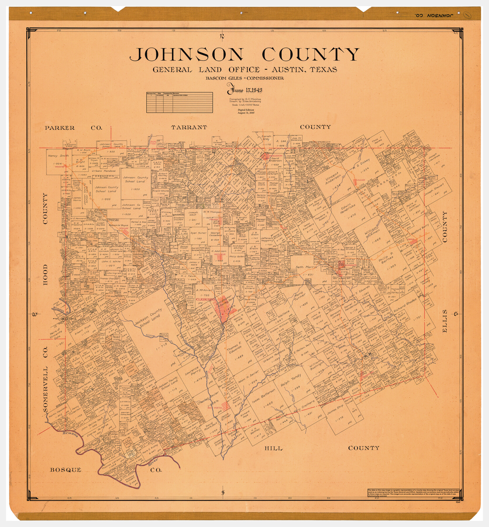
Johnson County
General Land Office Official County Map
-
Map/Doc
95549
-
Collection
General Map Collection
-
Object Dates
2019/8/31 (Revision Date)
1943/6/17 (Creation Date)
-
People and Organizations
Cheyenne Betancourt (Draftsman)
Eltea Armstrong (Draftsman)
G.C. Morriss (Compiler)
Bascom Giles (GLO Commissioner)
-
Counties
Johnson
-
Subjects
County OCM
-
Height x Width
43.3 x 40.2 inches
110.0 x 102.1 cm
-
Medium
digital image
-
Scale
1" = 2000 varas
Part of: General Map Collection
Presidio County Working Sketch 150

Print $20.00
- Digital $50.00
Presidio County Working Sketch 150
2002
Size 24.0 x 23.5 inches
Map/Doc 93490
Texas, Matagorda Bay, Matagorda Peninsula, Central Section

Print $20.00
- Digital $50.00
Texas, Matagorda Bay, Matagorda Peninsula, Central Section
1933
Size 28.3 x 42.7 inches
Map/Doc 69987

San Saba County Boundary File 77

Print $32.00
- Digital $50.00
San Saba County Boundary File 77
Size 9.2 x 7.7 inches
Map/Doc 58577
Coryell County Sketch File 11

Print $4.00
- Digital $50.00
Coryell County Sketch File 11
Size 8.7 x 11.7 inches
Map/Doc 19364
Real County Boundary File 1

Print $8.00
- Digital $50.00
Real County Boundary File 1
Size 9.3 x 5.9 inches
Map/Doc 58191
Flight Mission No. BRA-9M, Frame 63, Jefferson County

Print $20.00
- Digital $50.00
Flight Mission No. BRA-9M, Frame 63, Jefferson County
1953
Size 18.6 x 22.4 inches
Map/Doc 85646
Erath County Working Sketch 19

Print $20.00
- Digital $50.00
Erath County Working Sketch 19
1963
Size 30.1 x 27.6 inches
Map/Doc 69100

La Salle County Sketch File 49

Print $20.00
- Digital $50.00
La Salle County Sketch File 49
1942
Size 47.7 x 14.9 inches
Map/Doc 10519
Goliad County Working Sketch 13

Print $20.00
- Digital $50.00
Goliad County Working Sketch 13
1943
Size 28.3 x 40.8 inches
Map/Doc 63203
Travis County Boundary File 6

Print $109.00
- Digital $50.00
Travis County Boundary File 6
Size 14.6 x 9.1 inches
Map/Doc 59433
You may also like
Pecos County Rolled Sketch DK3

Print $20.00
- Digital $50.00
Pecos County Rolled Sketch DK3
1938
Size 35.3 x 42.3 inches
Map/Doc 9715

Travis County

Print $40.00
- Digital $50.00
Travis County
1936
Size 47.0 x 53.7 inches
Map/Doc 73305
United States - Gulf Coast Texas - Southern part of Laguna Madre

Print $20.00
- Digital $50.00
United States - Gulf Coast Texas - Southern part of Laguna Madre
1941
Size 26.7 x 18.5 inches
Map/Doc 72942
Hale County Rolled Sketch 3

Print $40.00
- Digital $50.00
Hale County Rolled Sketch 3
1891
Size 51.7 x 24.1 inches
Map/Doc 9093
Fifteenth Census 1930 Population - Texas

Print $20.00
- Digital $50.00
Fifteenth Census 1930 Population - Texas
1930
Size 19.5 x 22.6 inches
Map/Doc 2146
Duval County Boundary File 4

Print $40.00
- Digital $50.00
Duval County Boundary File 4
Size 39.5 x 13.7 inches
Map/Doc 52767
[Sketch for Mineral Application 11108 - Greens Bayou]
![2786, [Sketch for Mineral Application 11108 - Greens Bayou], General Map Collection](https://historictexasmaps.com/wmedia_w700/maps/2786-1.tif.jpg)
Print $20.00
- Digital $50.00
[Sketch for Mineral Application 11108 - Greens Bayou]
1922
Size 46.0 x 21.0 inches
Map/Doc 2786
Fort Bend County Sketch File 17 1/2

Print $52.00
- Digital $50.00
Fort Bend County Sketch File 17 1/2
1896
Size 11.2 x 8.7 inches
Map/Doc 22934
Childress County Rolled Sketch 5A

Print $20.00
- Digital $50.00
Childress County Rolled Sketch 5A
Size 32.9 x 21.9 inches
Map/Doc 5440
Sterling County Sketch File 26

Print $24.00
- Digital $50.00
Sterling County Sketch File 26
1989
Size 14.2 x 8.8 inches
Map/Doc 37194
Webb County Sketch File 14a

Print $40.00
- Digital $50.00
Webb County Sketch File 14a
1893
Size 17.4 x 13.7 inches
Map/Doc 39810