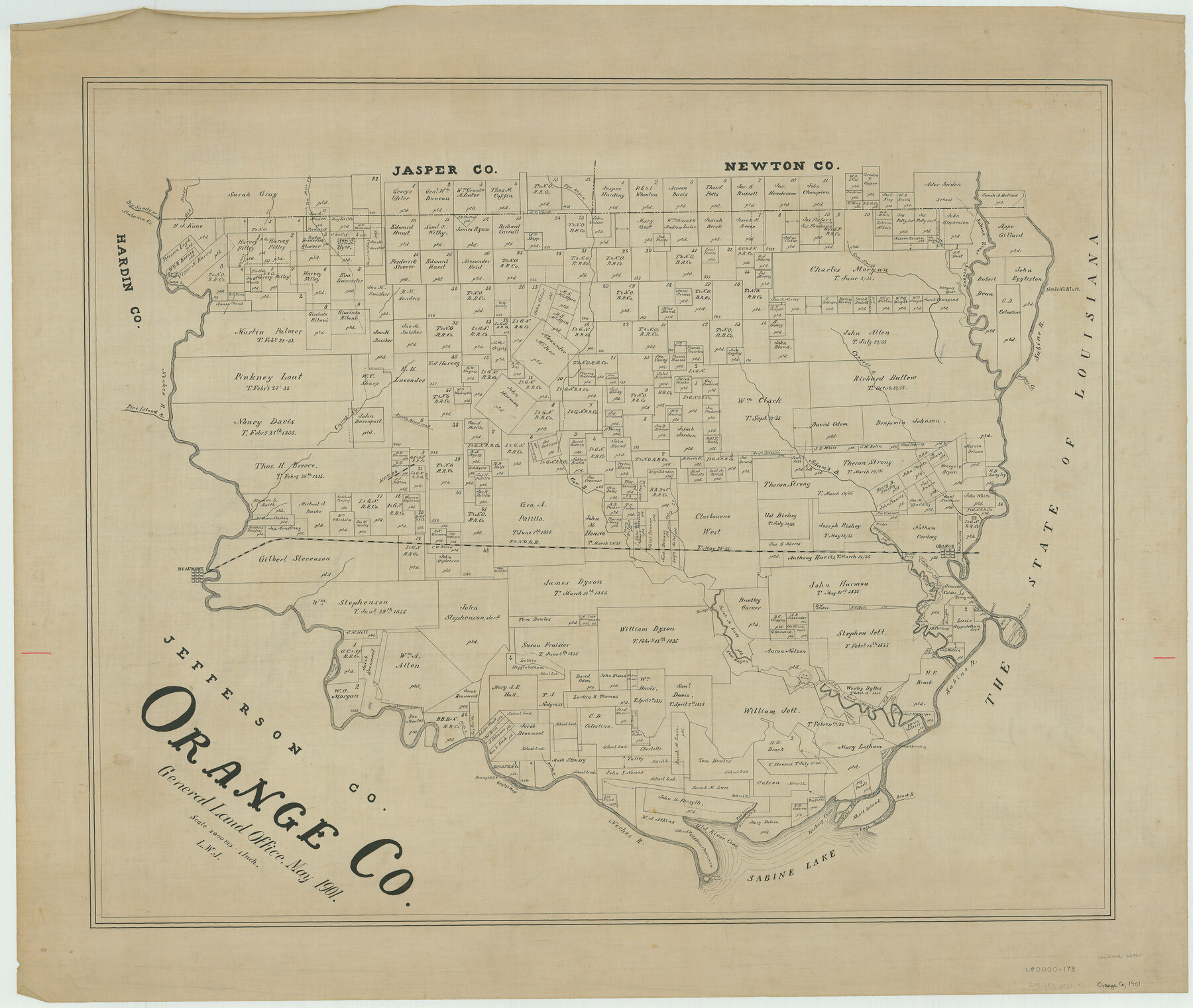
Orange Co.
-
Map/Doc
66961
-
Collection
General Map Collection
-
Object Dates
1901 (Creation Date)
-
People and Organizations
Texas General Land Office (Publisher)
L.W. Jelinek (Compiler)
L.W. Jelinek (Draftsman)
-
Counties
Orange
-
Subjects
County
-
Height x Width
28.2 x 33.4 inches
71.6 x 84.8 cm
Part of: General Map Collection
Orange County Sketch File 23

Print $36.00
- Digital $50.00
Orange County Sketch File 23
1911
Size 9.2 x 5.9 inches
Map/Doc 33344
Erath County Rolled Sketch 1

Print $40.00
- Digital $50.00
Erath County Rolled Sketch 1
1962
Size 37.6 x 69.0 inches
Map/Doc 8882
Flight Mission No. CRC-2R, Frame 186, Chambers County

Print $20.00
- Digital $50.00
Flight Mission No. CRC-2R, Frame 186, Chambers County
1956
Size 18.7 x 22.4 inches
Map/Doc 84764
North Part Brewster Co.

Print $20.00
- Digital $50.00
North Part Brewster Co.
1914
Size 38.7 x 47.8 inches
Map/Doc 16948
King County Working Sketch 16

Print $40.00
- Digital $50.00
King County Working Sketch 16
1979
Size 41.4 x 59.4 inches
Map/Doc 70180
Glasscock County Rolled Sketch 5

Print $20.00
- Digital $50.00
Glasscock County Rolled Sketch 5
1944
Size 41.4 x 33.7 inches
Map/Doc 6016
Wilson County Rolled Sketch 3

Print $20.00
- Digital $50.00
Wilson County Rolled Sketch 3
1956
Size 25.8 x 22.8 inches
Map/Doc 8369
Coryell County Working Sketch 32

Print $20.00
- Digital $50.00
Coryell County Working Sketch 32
2022
Size 25.3 x 36.9 inches
Map/Doc 96966
King County Boundary File 3

Print $54.00
- Digital $50.00
King County Boundary File 3
Size 14.1 x 8.5 inches
Map/Doc 64896

A Map of the Republic of Texas and the adjacent territories, indicating the grants of land conceded under the empresario system of Mexico

Print $20.00
- Digital $50.00
A Map of the Republic of Texas and the adjacent territories, indicating the grants of land conceded under the empresario system of Mexico
1841
Size 13.8 x 16.6 inches
Map/Doc 93752
Sutton County Sketch File 8

Print $20.00
- Digital $50.00
Sutton County Sketch File 8
1891
Size 24.9 x 31.6 inches
Map/Doc 12379
You may also like
Kleberg County Rolled Sketch 10-31

Print $20.00
- Digital $50.00
Kleberg County Rolled Sketch 10-31
1952
Size 37.9 x 40.3 inches
Map/Doc 9398
Working Sketch in Dimmit Co.

Print $20.00
- Digital $50.00
Working Sketch in Dimmit Co.
1883
Size 14.9 x 14.6 inches
Map/Doc 436
Flight Mission No. CRC-1R, Frame 153, Chambers County

Print $20.00
- Digital $50.00
Flight Mission No. CRC-1R, Frame 153, Chambers County
1956
Size 18.8 x 22.5 inches
Map/Doc 84715
Hardin County Sketch File 3a

Print $12.00
- Digital $50.00
Hardin County Sketch File 3a
1858
Size 10.0 x 7.9 inches
Map/Doc 25088
Garza County Sketch File C

Print $22.00
- Digital $50.00
Garza County Sketch File C
1900
Size 18.0 x 10.8 inches
Map/Doc 24013
Pecos County Rolled Sketch 47

Print $20.00
- Digital $50.00
Pecos County Rolled Sketch 47
1913
Size 20.3 x 43.8 inches
Map/Doc 7225
Red River Co.

Print $20.00
- Digital $50.00
Red River Co.
1905
Size 46.7 x 39.6 inches
Map/Doc 66994
Montgomery County Sketch File 20

Print $38.00
- Digital $50.00
Montgomery County Sketch File 20
1932
Size 14.3 x 8.8 inches
Map/Doc 31847
League 206, Ochiltree County School Land, Bailey and Lamb Counties, Texas

Print $20.00
- Digital $50.00
League 206, Ochiltree County School Land, Bailey and Lamb Counties, Texas
1954
Size 36.9 x 25.0 inches
Map/Doc 92537
Webb County Rolled Sketch 53

Print $40.00
- Digital $50.00
Webb County Rolled Sketch 53
1944
Size 84.0 x 32.3 inches
Map/Doc 63914
Austin County Working Sketch 4

Print $20.00
- Digital $50.00
Austin County Working Sketch 4
1959
Size 29.8 x 34.8 inches
Map/Doc 67245
Liberty County Sketch File 48

Print $6.00
- Digital $50.00
Liberty County Sketch File 48
1879
Size 12.2 x 8.3 inches
Map/Doc 30010