Montgomery County Sketch File 20
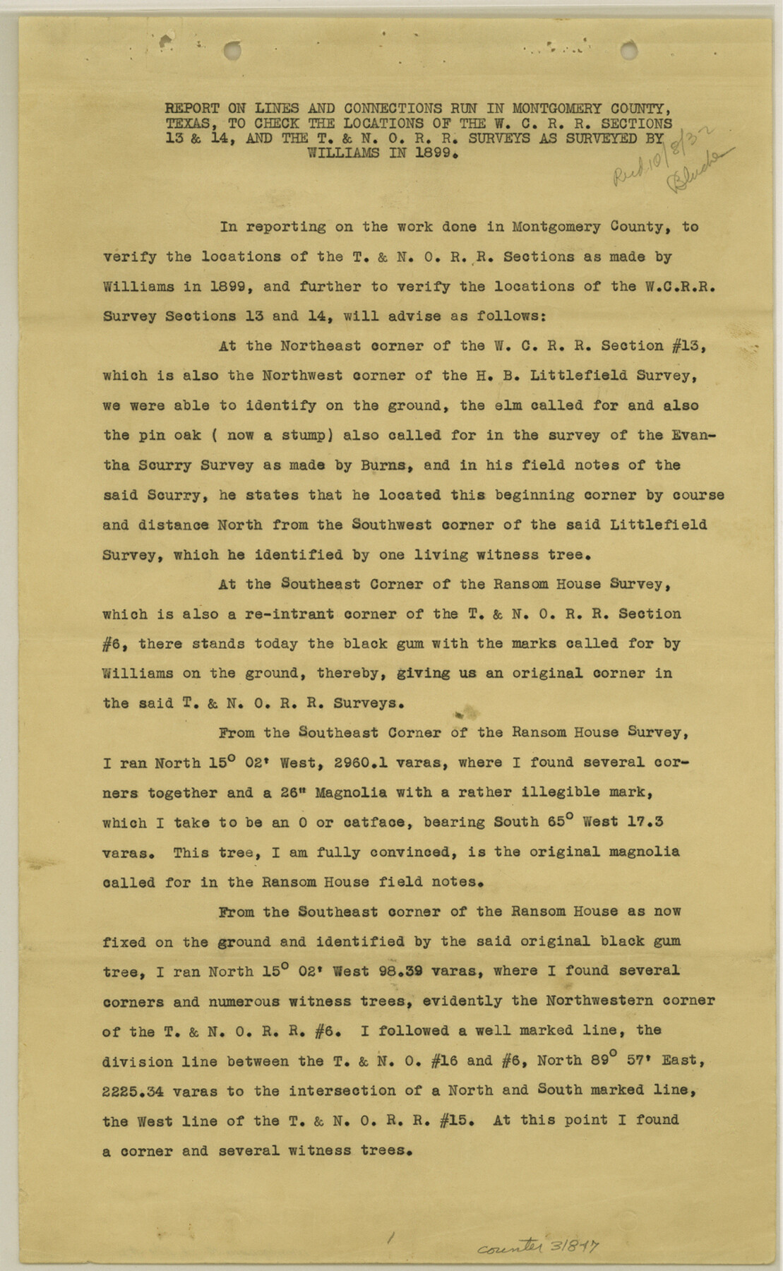
Report [and sketch] on lines and connections run in Montgomery County, Texas, to check the locations of the W. C. R.R. sections 13 & 14, and the T. & N. O. R.R. surveys as surveyed by Williams in 1899
-
Map/Doc
31847
-
Collection
General Map Collection
-
Object Dates
10/7/1932 (Creation Date)
10/8/1932 (File Date)
-
People and Organizations
J.S. Boyles (Surveyor/Engineer)
-
Counties
Montgomery
-
Subjects
Surveying Sketch File
-
Height x Width
14.3 x 8.8 inches
36.3 x 22.4 cm
-
Medium
multi-page, multi-format
-
Scale
1" = 360 varas
-
Features
Caney Creek
Part of: General Map Collection
McCulloch County Rolled Sketch 8

Print $40.00
- Digital $50.00
McCulloch County Rolled Sketch 8
1982
Size 51.3 x 31.4 inches
Map/Doc 10292
[The S.K. Ry. of Texas, State Line to Pecos, Reeves Co., Texas]
![64163, [The S.K. Ry. of Texas, State Line to Pecos, Reeves Co., Texas], General Map Collection](https://historictexasmaps.com/wmedia_w700/maps/64163.tif.jpg)
Print $40.00
- Digital $50.00
[The S.K. Ry. of Texas, State Line to Pecos, Reeves Co., Texas]
1910
Size 19.3 x 120.2 inches
Map/Doc 64163
Hood County Working Sketch 2

Print $20.00
- Digital $50.00
Hood County Working Sketch 2
1956
Size 20.5 x 25.5 inches
Map/Doc 66196
Bee County Sketch File 31

Print $6.00
- Digital $50.00
Bee County Sketch File 31
1886
Size 12.8 x 8.2 inches
Map/Doc 14344
Andrews County Sketch File 9

Print $8.00
- Digital $50.00
Andrews County Sketch File 9
1949
Size 14.2 x 8.6 inches
Map/Doc 12853
Current Miscellaneous File 105

Print $18.00
- Digital $50.00
Current Miscellaneous File 105
Size 8.8 x 14.2 inches
Map/Doc 74680
Clay County Boundary File 14

Print $80.00
- Digital $50.00
Clay County Boundary File 14
Size 63.1 x 15.4 inches
Map/Doc 51416
Sketch of the route taken by a scouting party from Phantom Hill to Double Mountain, Texas

Print $20.00
- Digital $50.00
Sketch of the route taken by a scouting party from Phantom Hill to Double Mountain, Texas
1852
Size 25.3 x 13.4 inches
Map/Doc 2006
Reagan County Sketch File 5

Print $12.00
- Digital $50.00
Reagan County Sketch File 5
1927
Size 11.2 x 8.7 inches
Map/Doc 34980
Denton County Working Sketch 33

Print $20.00
- Digital $50.00
Denton County Working Sketch 33
2002
Size 35.3 x 46.1 inches
Map/Doc 78203
Maverick County Sketch File 2

Print $40.00
- Digital $50.00
Maverick County Sketch File 2
1875
Size 18.2 x 14.0 inches
Map/Doc 31031
Loving County Rolled Sketch 13

Print $20.00
- Digital $50.00
Loving County Rolled Sketch 13
2006
Size 43.6 x 45.0 inches
Map/Doc 83650
You may also like
Young County Sketch File 1

Print $8.00
- Digital $50.00
Young County Sketch File 1
1853
Size 7.9 x 9.7 inches
Map/Doc 40843
[D. Boone, Block A27]
![92640, [D. Boone, Block A27], Twichell Survey Records](https://historictexasmaps.com/wmedia_w700/maps/92640-1.tif.jpg)
Print $20.00
- Digital $50.00
[D. Boone, Block A27]
Size 37.0 x 24.0 inches
Map/Doc 92640
Knox County Sketch File 10a

Print $40.00
- Digital $50.00
Knox County Sketch File 10a
1902
Size 9.5 x 19.0 inches
Map/Doc 29223
Jasper County Sketch File 12a

Print $16.00
- Digital $50.00
Jasper County Sketch File 12a
1881
Size 13.0 x 8.4 inches
Map/Doc 27794
Official Map of the City of Bryan from Actual Survey [East half]
![3203, Official Map of the City of Bryan from Actual Survey [East half], General Map Collection](https://historictexasmaps.com/wmedia_w700/maps/3203.tif.jpg)
Print $40.00
- Digital $50.00
Official Map of the City of Bryan from Actual Survey [East half]
1898
Size 52.3 x 27.4 inches
Map/Doc 3203
Crane County Rolled Sketch 29

Print $20.00
- Digital $50.00
Crane County Rolled Sketch 29
2024
Size 24.6 x 35.5 inches
Map/Doc 97338
Smith County Working Sketch 4

Print $20.00
- Digital $50.00
Smith County Working Sketch 4
1913
Size 13.5 x 17.9 inches
Map/Doc 63889
Flight Mission No. BRA-8M, Frame 67, Jefferson County

Print $20.00
- Digital $50.00
Flight Mission No. BRA-8M, Frame 67, Jefferson County
1953
Size 18.8 x 22.5 inches
Map/Doc 85587
Jackson County Working Sketch 6

Print $20.00
- Digital $50.00
Jackson County Working Sketch 6
1971
Size 17.0 x 21.7 inches
Map/Doc 66454
Lubbock County Boundary File 3

Print $2.00
- Digital $50.00
Lubbock County Boundary File 3
Size 11.3 x 8.8 inches
Map/Doc 56490
Midland County Boundary File 5

Print $6.00
- Digital $50.00
Midland County Boundary File 5
Size 9.6 x 6.0 inches
Map/Doc 57195
Fort Bend County Sketch File 21

Print $4.00
- Digital $50.00
Fort Bend County Sketch File 21
1882
Size 8.8 x 13.4 inches
Map/Doc 22954