Current Miscellaneous File 105
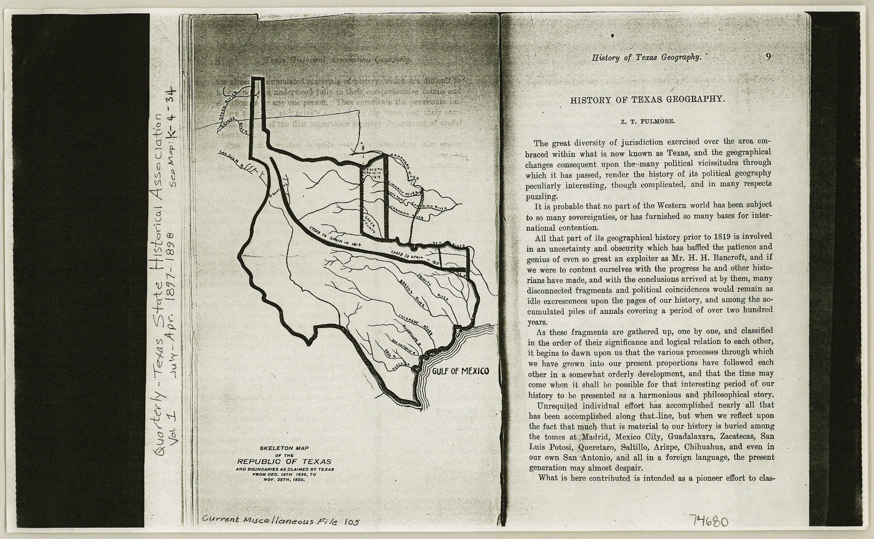
History of Texas Geography
-
Map/Doc
74680
-
Collection
General Map Collection
-
People and Organizations
Z.T. Fulmore (Author)
-
Subjects
Republic of Texas Texas Boundaries
-
Height x Width
8.8 x 14.2 inches
22.4 x 36.1 cm
-
Comments
From Texas Historical Association Quarterly, Vol. 1, July-Apr 1897-1898, pp. 8-25
Part of: General Map Collection
Crosby County Sketch File 35

Print $4.00
- Digital $50.00
Crosby County Sketch File 35
Size 8.5 x 12.1 inches
Map/Doc 20106
Jefferson County Rolled Sketch 46

Print $3.00
- Digital $50.00
Jefferson County Rolled Sketch 46
Size 15.7 x 10.0 inches
Map/Doc 9304
Ward County Rolled Sketch 7

Print $40.00
- Digital $50.00
Ward County Rolled Sketch 7
1907
Size 33.9 x 91.0 inches
Map/Doc 10103
Map of the Central and Montgomery Railroad

Print $20.00
- Digital $50.00
Map of the Central and Montgomery Railroad
1881
Size 12.6 x 36.8 inches
Map/Doc 64141
San Augustine County Working Sketch 5

Print $20.00
- Digital $50.00
San Augustine County Working Sketch 5
1935
Size 39.0 x 37.4 inches
Map/Doc 63692
Orange County Working Sketch 53

Print $20.00
- Digital $50.00
Orange County Working Sketch 53
2007
Size 34.1 x 46.0 inches
Map/Doc 87371
Edwards County Rolled Sketch 26

Print $20.00
- Digital $50.00
Edwards County Rolled Sketch 26
1958
Size 25.0 x 17.5 inches
Map/Doc 5812
Caldwell County Sketch File 3

Print $4.00
- Digital $50.00
Caldwell County Sketch File 3
1872
Size 12.7 x 8.1 inches
Map/Doc 35827
Galveston County NRC Article 33.136 Sketch 77

Print $44.00
- Digital $50.00
Galveston County NRC Article 33.136 Sketch 77
2015
Size 24.0 x 36.0 inches
Map/Doc 94991
El Paso County Rolled Sketch 49

Print $40.00
- Digital $50.00
El Paso County Rolled Sketch 49
Size 10.5 x 99.9 inches
Map/Doc 8875
Cameron County Rolled Sketch 14

Print $53.00
- Digital $50.00
Cameron County Rolled Sketch 14
1954
Size 6.8 x 8.8 inches
Map/Doc 43894
Menard County Boundary File 11

Print $2.00
- Digital $50.00
Menard County Boundary File 11
Size 11.2 x 8.7 inches
Map/Doc 57098
You may also like
McMullen County Working Sketch 21

Print $40.00
- Digital $50.00
McMullen County Working Sketch 21
1947
Size 38.3 x 53.4 inches
Map/Doc 70722
Reagan County Rolled Sketch FF

Print $20.00
- Digital $50.00
Reagan County Rolled Sketch FF
Size 35.0 x 17.8 inches
Map/Doc 7451
San Jacinto County Sketch File 17

Print $40.00
San Jacinto County Sketch File 17
1934
Size 60.1 x 26.3 inches
Map/Doc 10598
[T. & P. Block 36, Townships 3N - 5N]
![90552, [T. & P. Block 36, Townships 3N - 5N], Twichell Survey Records](https://historictexasmaps.com/wmedia_w700/maps/90552.tif.jpg)
Print $20.00
- Digital $50.00
[T. & P. Block 36, Townships 3N - 5N]
Size 15.5 x 47.8 inches
Map/Doc 90552
Right of Way & Track Map, St. Louis, Brownsville & Mexico Ry. operated by St. Louis, Brownsville & Mexico Ry. Co.

Print $40.00
- Digital $50.00
Right of Way & Track Map, St. Louis, Brownsville & Mexico Ry. operated by St. Louis, Brownsville & Mexico Ry. Co.
1919
Size 25.6 x 57.1 inches
Map/Doc 64616
Yoakum County Boundary File 1a

Print $20.00
- Digital $50.00
Yoakum County Boundary File 1a
Size 7.8 x 29.5 inches
Map/Doc 60196
![94182, San Antonio [Verso], General Map Collection](https://historictexasmaps.com/wmedia_w700/maps/94182.tif.jpg)
San Saba County Sketch File 5

Print $4.00
- Digital $50.00
San Saba County Sketch File 5
Size 12.8 x 8.0 inches
Map/Doc 36412
Texas City Channel, Texas, Channel and Turning Basin Dredging - Sheet 5

Print $20.00
- Digital $50.00
Texas City Channel, Texas, Channel and Turning Basin Dredging - Sheet 5
1958
Size 28.2 x 40.9 inches
Map/Doc 61835
Hill County Sketch File 9

Print $4.00
- Digital $50.00
Hill County Sketch File 9
1857
Size 8.3 x 10.3 inches
Map/Doc 26476
Irion County Working Sketch 9

Print $20.00
- Digital $50.00
Irion County Working Sketch 9
1941
Size 13.6 x 17.2 inches
Map/Doc 66418
Val Verde County Sketch File XXX7

Print $6.00
- Digital $50.00
Val Verde County Sketch File XXX7
Size 11.0 x 15.4 inches
Map/Doc 39104