Ward County Rolled Sketch 7
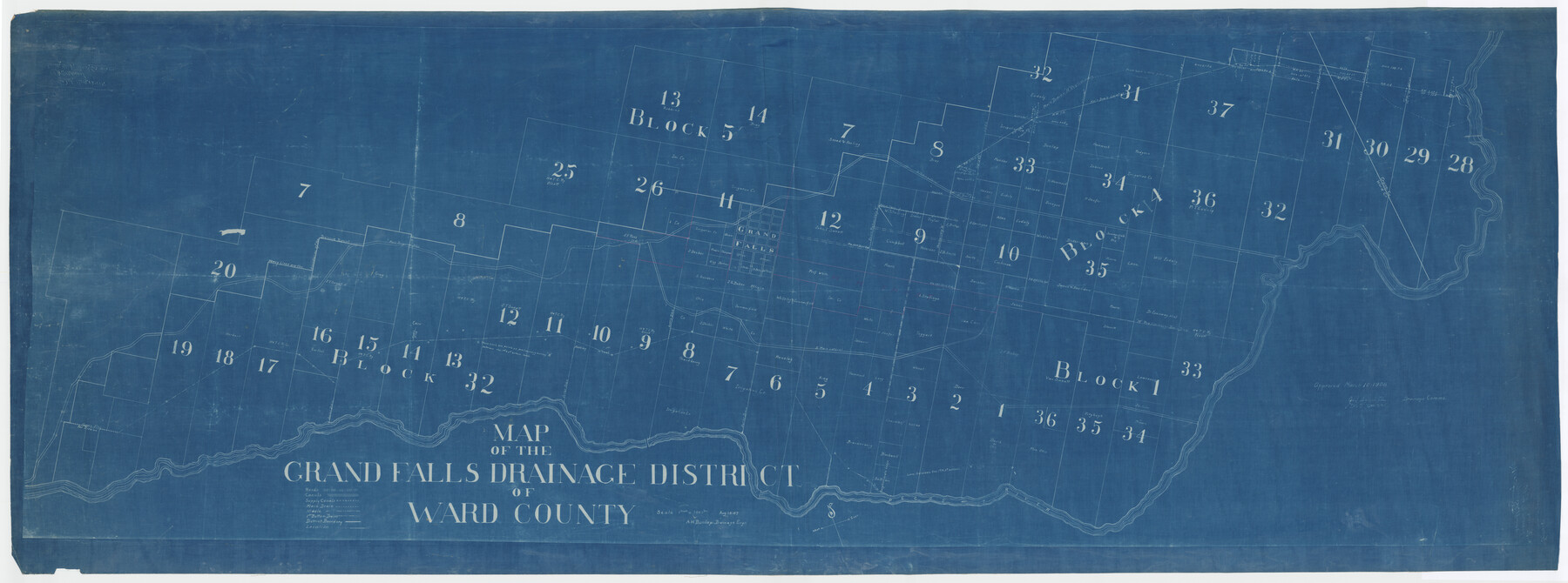
Map of the Grand Falls Drainage District of Ward County
-
Map/Doc
10103
-
Collection
General Map Collection
-
Object Dates
1907/8/10 (Creation Date)
-
People and Organizations
A.H. Dunlap (Surveyor/Engineer)
-
Counties
Ward
-
Subjects
Surveying Rolled Sketch
-
Height x Width
33.9 x 91.0 inches
86.1 x 231.1 cm
-
Medium
blueprint/diazo
-
Scale
1" = 1000 feet
Part of: General Map Collection
Live Oak County Sketch File 26

Print $6.00
- Digital $50.00
Live Oak County Sketch File 26
1922
Size 7.1 x 8.6 inches
Map/Doc 30309
Taylor County Sketch File 20

Print $20.00
- Digital $50.00
Taylor County Sketch File 20
1950
Size 32.1 x 46.1 inches
Map/Doc 10385
Upton County Working Sketch 23

Print $20.00
- Digital $50.00
Upton County Working Sketch 23
1953
Size 21.4 x 20.0 inches
Map/Doc 69519
Gregg County Sketch File 1F

Print $4.00
- Digital $50.00
Gregg County Sketch File 1F
1850
Size 12.2 x 7.8 inches
Map/Doc 24547
Hemphill County Working Sketch Graphic Index - sheet 1

Print $20.00
- Digital $50.00
Hemphill County Working Sketch Graphic Index - sheet 1
1899
Size 40.1 x 38.2 inches
Map/Doc 76574
Railroad Track Map, H&TCRRCo., Falls County, Texas

Print $4.00
- Digital $50.00
Railroad Track Map, H&TCRRCo., Falls County, Texas
1918
Size 11.7 x 18.5 inches
Map/Doc 62858
Travis County Appraisal District Plat Map 3_0721

Print $20.00
- Digital $50.00
Travis County Appraisal District Plat Map 3_0721
Size 21.5 x 26.3 inches
Map/Doc 94227
Menard County Sketch File 30

Print $4.00
- Digital $50.00
Menard County Sketch File 30
1977
Size 14.3 x 8.6 inches
Map/Doc 31571
Karnes County Rolled Sketch 4

Print $20.00
- Digital $50.00
Karnes County Rolled Sketch 4
1961
Size 33.4 x 37.7 inches
Map/Doc 9667
San Patricio County Sketch File 28

Print $53.00
San Patricio County Sketch File 28
1935
Size 9.4 x 7.0 inches
Map/Doc 36087
Cottle County

Print $20.00
- Digital $50.00
Cottle County
1908
Size 43.9 x 39.0 inches
Map/Doc 66788
Galveston to Rio Grande

Print $20.00
- Digital $50.00
Galveston to Rio Grande
1946
Size 44.6 x 36.6 inches
Map/Doc 69952
You may also like
Flight Mission No. BRA-8M, Frame 127, Jefferson County

Print $20.00
- Digital $50.00
Flight Mission No. BRA-8M, Frame 127, Jefferson County
1953
Size 18.6 x 22.3 inches
Map/Doc 85623
Texas Gulf Coast from Sabine River to the Rio Grande

Print $20.00
- Digital $50.00
Texas Gulf Coast from Sabine River to the Rio Grande
1953
Size 45.9 x 43.6 inches
Map/Doc 2945
Maps of Gulf Intracoastal Waterway, Texas - Sabine River to the Rio Grande and connecting waterways including ship channels

Print $20.00
- Digital $50.00
Maps of Gulf Intracoastal Waterway, Texas - Sabine River to the Rio Grande and connecting waterways including ship channels
1966
Size 14.6 x 22.2 inches
Map/Doc 61946
El Paso County Working Sketch 23

Print $20.00
- Digital $50.00
El Paso County Working Sketch 23
1961
Size 22.3 x 28.8 inches
Map/Doc 69045
Menard County Sketch File 29

Print $20.00
- Digital $50.00
Menard County Sketch File 29
1962
Size 21.0 x 41.1 inches
Map/Doc 10543
Lipscomb County

Print $20.00
- Digital $50.00
Lipscomb County
1878
Size 18.1 x 16.4 inches
Map/Doc 3816
Harris County Aerial Photograph Index Sheet 8

Print $20.00
- Digital $50.00
Harris County Aerial Photograph Index Sheet 8
1953
Size 22.2 x 16.8 inches
Map/Doc 83702
Aransas County NRC Article 33.136 Sketch 10

Print $26.00
- Digital $50.00
Aransas County NRC Article 33.136 Sketch 10
Size 24.2 x 36.0 inches
Map/Doc 95016

Galveston County Rolled Sketch 44

Print $20.00
- Digital $50.00
Galveston County Rolled Sketch 44
1991
Size 24.9 x 36.9 inches
Map/Doc 5973
[Sketch for Mineral Application 26546 - Sabine River between Hawkins Creek and east boundary line of BBB&C RR Co. Surveys, R. S. Rathke]
![65665, [Sketch for Mineral Application 26546 - Sabine River between Hawkins Creek and east boundary line of BBB&C RR Co. Surveys, R. S. Rathke], General Map Collection](https://historictexasmaps.com/wmedia_w700/maps/65665.tif.jpg)
Print $40.00
- Digital $50.00
[Sketch for Mineral Application 26546 - Sabine River between Hawkins Creek and east boundary line of BBB&C RR Co. Surveys, R. S. Rathke]
1931
Size 25.5 x 75.1 inches
Map/Doc 65665
Flight Mission No. CLL-1N, Frame 14, Willacy County

Print $20.00
- Digital $50.00
Flight Mission No. CLL-1N, Frame 14, Willacy County
1954
Size 18.2 x 22.1 inches
Map/Doc 87001