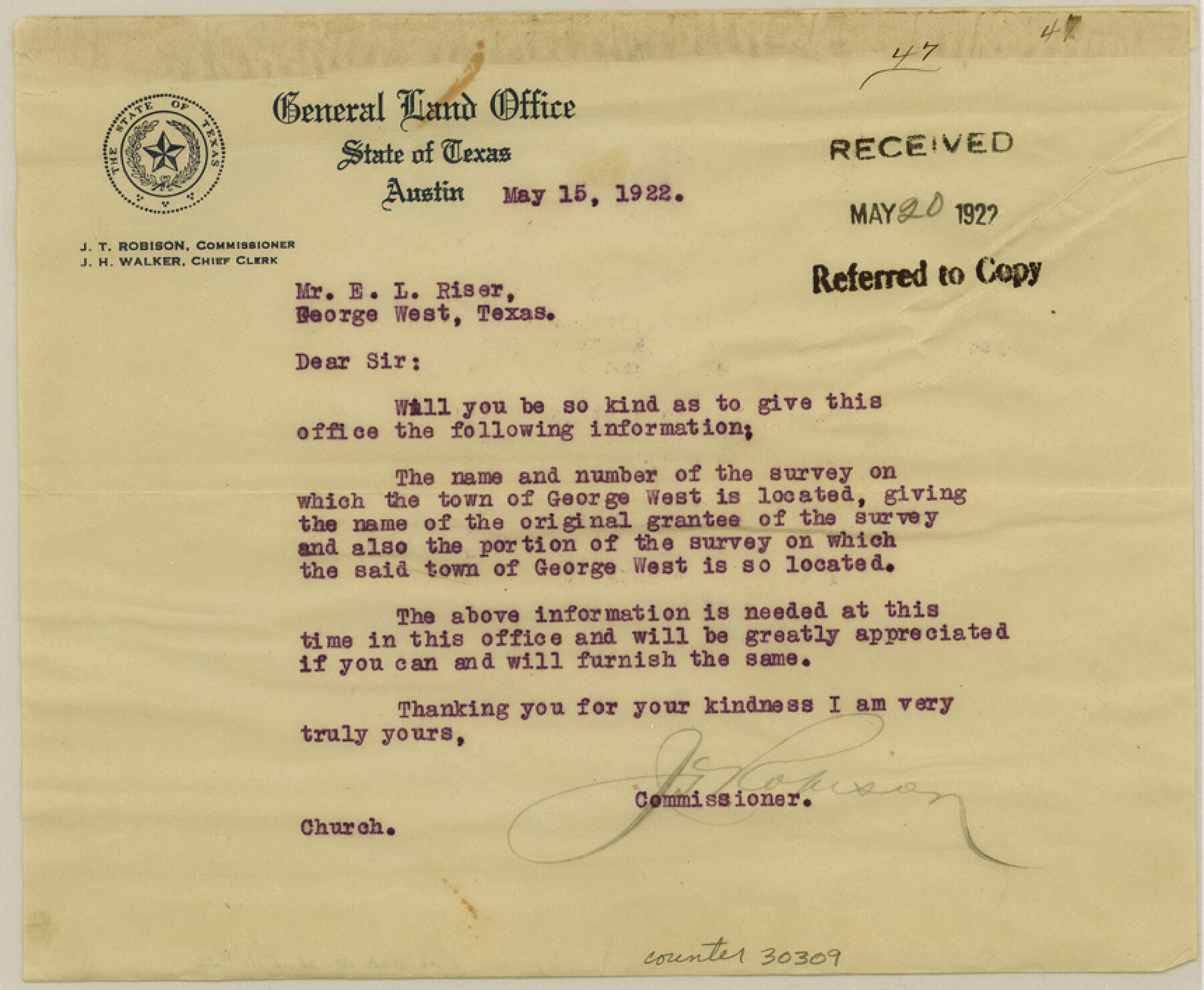
Live Oak County Sketch File 26
[Sketch showing location of George West]
-
Map/Doc
30309
-
Collection
General Map Collection
-
Object Dates
5/15/1922 (Creation Date)
5/20/1922 (File Date)
5/15/1922 (Correspondence Date)
-
People and Organizations
E.L. Riser (Surveyor/Engineer)
-
Counties
Live Oak
-
Subjects
Surveying Sketch File
-
Height x Width
7.1 x 8.6 inches
18.0 x 21.8 cm
-
Medium
paper, print
Part of: General Map Collection
Outer Continental Shelf Leasing Maps (Louisiana Offshore Operations)

Print $20.00
- Digital $50.00
Outer Continental Shelf Leasing Maps (Louisiana Offshore Operations)
1954
Size 18.2 x 16.0 inches
Map/Doc 76105
Flight Mission No. CUG-2P, Frame 8, Kleberg County

Print $20.00
- Digital $50.00
Flight Mission No. CUG-2P, Frame 8, Kleberg County
1956
Size 18.5 x 22.2 inches
Map/Doc 86180


Flight Mission No. BQR-7K, Frame 32, Brazoria County

Print $20.00
- Digital $50.00
Flight Mission No. BQR-7K, Frame 32, Brazoria County
1952
Size 18.6 x 22.2 inches
Map/Doc 84030
Harris County Working Sketch 117

Print $20.00
- Digital $50.00
Harris County Working Sketch 117
1984
Size 28.2 x 25.5 inches
Map/Doc 66009
Red River County Working Sketch 81-1

Print $20.00
- Digital $50.00
Red River County Working Sketch 81-1
1987
Size 14.6 x 18.4 inches
Map/Doc 72064
Matagorda County Sketch File 4

Print $4.00
- Digital $50.00
Matagorda County Sketch File 4
1876
Size 7.9 x 12.8 inches
Map/Doc 30734
Traced from Genl. Arista's map captured by the American Army under Genl. Taylor at Resaca de la Palma 9th May '46 and presented to James K. Polk, President U. States

Print $20.00
- Digital $50.00
Traced from Genl. Arista's map captured by the American Army under Genl. Taylor at Resaca de la Palma 9th May '46 and presented to James K. Polk, President U. States
1846
Size 18.2 x 27.4 inches
Map/Doc 73061
Franklin County Sketch File 6

Print $4.00
- Digital $50.00
Franklin County Sketch File 6
1853
Size 9.6 x 7.4 inches
Map/Doc 23018
Castro County Sketch File 4d

Print $4.00
- Digital $50.00
Castro County Sketch File 4d
Size 13.6 x 8.8 inches
Map/Doc 17471
Childress County Sketch File 7

Print $20.00
- Digital $50.00
Childress County Sketch File 7
Size 14.9 x 17.6 inches
Map/Doc 11079
You may also like
Hutchinson County Rolled Sketch 44-14

Print $20.00
- Digital $50.00
Hutchinson County Rolled Sketch 44-14
2002
Size 24.0 x 36.0 inches
Map/Doc 77550
Eastland County Sketch File 1

Print $8.00
- Digital $50.00
Eastland County Sketch File 1
Size 9.0 x 7.9 inches
Map/Doc 21555
Kimble County Working Sketch 28

Print $20.00
- Digital $50.00
Kimble County Working Sketch 28
1938
Size 29.4 x 23.2 inches
Map/Doc 70096
Cottle County Sketch File 14

Print $50.00
- Digital $50.00
Cottle County Sketch File 14
1918
Size 11.3 x 8.8 inches
Map/Doc 19491
Harris County Working Sketch 17

Print $20.00
- Digital $50.00
Harris County Working Sketch 17
1919
Size 40.0 x 41.6 inches
Map/Doc 65909
Travis County Rolled Sketch 11

Print $20.00
- Digital $50.00
Travis County Rolled Sketch 11
Size 23.3 x 37.9 inches
Map/Doc 8014
Reagan County Rolled Sketch 4

Print $20.00
- Digital $50.00
Reagan County Rolled Sketch 4
1928
Size 25.4 x 27.4 inches
Map/Doc 7433
Flight Mission No. DCL-7C, Frame 61, Kenedy County

Print $20.00
- Digital $50.00
Flight Mission No. DCL-7C, Frame 61, Kenedy County
1943
Size 15.4 x 15.2 inches
Map/Doc 86049
Bandera County Working Sketch 14

Print $20.00
- Digital $50.00
Bandera County Working Sketch 14
1934
Size 28.0 x 30.9 inches
Map/Doc 67607
Hale County Sketch File 18

Print $4.00
- Digital $50.00
Hale County Sketch File 18
1903
Size 11.0 x 8.6 inches
Map/Doc 24749
Dickens County Sketch File D2

Print $44.00
- Digital $50.00
Dickens County Sketch File D2
Size 27.2 x 19.1 inches
Map/Doc 20839
Gray County Working Sketch 1

Print $40.00
- Digital $50.00
Gray County Working Sketch 1
Size 121.0 x 38.8 inches
Map/Doc 63232