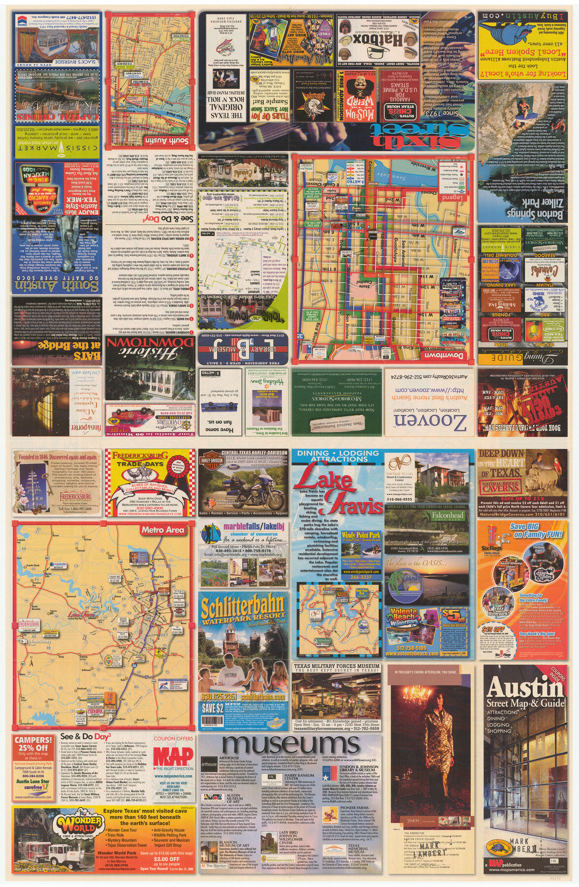
Austin Street Map & Guide
[Recto - Map of Downtown and Metro Area plus advertisements]
-
Map/Doc
94351
-
Collection
General Map Collection
-
Object Dates
2007 (Edition Date)
-
People and Organizations
MAP (Publisher)
Mark Lambert (Donor)
-
Counties
Travis
-
Subjects
City
-
Height x Width
35.5 x 23.2 inches
90.2 x 58.9 cm
-
Medium
paper, etching/engraving/lithograph
-
Comments
Donated by Mark Lambert. For street map and index on verso, see 94352. For research only.
Related maps

Part of: General Map Collection
La Salle County Working Sketch 41

Print $20.00
- Digital $50.00
La Salle County Working Sketch 41
1969
Size 29.4 x 26.9 inches
Map/Doc 70342
Brazoria County Rolled Sketch 46

Print $40.00
- Digital $50.00
Brazoria County Rolled Sketch 46
1950
Size 30.7 x 57.3 inches
Map/Doc 8462
Walker County Sketch File 1

Print $4.00
- Digital $50.00
Walker County Sketch File 1
1853
Size 9.7 x 8.3 inches
Map/Doc 39547
Rockwall County Boundary File 75

Print $18.00
- Digital $50.00
Rockwall County Boundary File 75
Size 9.0 x 11.7 inches
Map/Doc 58472
Jefferson County Sketch File 52

Print $2.00
- Digital $50.00
Jefferson County Sketch File 52
1985
Size 9.1 x 14.4 inches
Map/Doc 28254
Culberson County Rolled Sketch 18

Print $6.00
- Digital $50.00
Culberson County Rolled Sketch 18
1911
Size 24.1 x 34.5 inches
Map/Doc 5650
Kenedy County Rolled Sketch 4

Print $40.00
- Digital $50.00
Kenedy County Rolled Sketch 4
1904
Size 39.4 x 57.6 inches
Map/Doc 10654
Goliad County Sketch File 22

Print $12.00
- Digital $50.00
Goliad County Sketch File 22
1855
Size 12.8 x 8.1 inches
Map/Doc 24289
Lampasas County Boundary File 16

Print $14.00
- Digital $50.00
Lampasas County Boundary File 16
Size 8.9 x 8.2 inches
Map/Doc 56216
Roberts County Working Sketch 32

Print $20.00
- Digital $50.00
Roberts County Working Sketch 32
1978
Size 26.6 x 22.5 inches
Map/Doc 63558
Val Verde County Sketch File B

Print $28.00
- Digital $50.00
Val Verde County Sketch File B
1897
Size 20.2 x 15.0 inches
Map/Doc 12542
Newton County Sketch File 41

Print $44.00
- Digital $50.00
Newton County Sketch File 41
1930
Size 11.2 x 8.7 inches
Map/Doc 32421
You may also like
Flight Mission No. BQY-4M, Frame 56, Harris County

Print $20.00
- Digital $50.00
Flight Mission No. BQY-4M, Frame 56, Harris County
1953
Size 18.6 x 22.4 inches
Map/Doc 85265
[Sketch for Mineral Application 19560 - 19588 - San Bernard River]
![65659, [Sketch for Mineral Application 19560 - 19588 - San Bernard River], General Map Collection](https://historictexasmaps.com/wmedia_w700/maps/65659.tif.jpg)
Print $40.00
- Digital $50.00
[Sketch for Mineral Application 19560 - 19588 - San Bernard River]
Size 32.7 x 97.6 inches
Map/Doc 65659
San Patricio County Rolled Sketch 7B

Print $20.00
- Digital $50.00
San Patricio County Rolled Sketch 7B
1870
Size 42.3 x 29.1 inches
Map/Doc 7573
Working Sketch in Falls and Limestone Counties

Print $20.00
- Digital $50.00
Working Sketch in Falls and Limestone Counties
1922
Size 15.9 x 34.8 inches
Map/Doc 91088
Map of Montague County

Print $20.00
- Digital $50.00
Map of Montague County
1868
Size 19.9 x 16.9 inches
Map/Doc 3888
General Highway Map, Mason County, Texas

Print $20.00
General Highway Map, Mason County, Texas
1940
Size 18.2 x 24.5 inches
Map/Doc 79186
Amistad International Reservoir on Rio Grande 61

Print $20.00
- Digital $50.00
Amistad International Reservoir on Rio Grande 61
1949
Size 28.4 x 39.4 inches
Map/Doc 73346
[Map showing Sanborn's Addition and Denver Heights Addition]
![91829, [Map showing Sanborn's Addition and Denver Heights Addition], Twichell Survey Records](https://historictexasmaps.com/wmedia_w700/maps/91829-1.tif.jpg)
Print $20.00
- Digital $50.00
[Map showing Sanborn's Addition and Denver Heights Addition]
Size 22.5 x 38.9 inches
Map/Doc 91829
Kleberg County Boundary File 2a

Print $40.00
- Digital $50.00
Kleberg County Boundary File 2a
Size 15.4 x 58.3 inches
Map/Doc 64977
Nueces County NRC Article 33.136 Sketch 3

Print $68.00
- Digital $50.00
Nueces County NRC Article 33.136 Sketch 3
2002
Size 24.7 x 36.5 inches
Map/Doc 87922
Gregg County Rolled Sketch 25

Print $40.00
- Digital $50.00
Gregg County Rolled Sketch 25
1933
Size 27.3 x 51.7 inches
Map/Doc 9076
Hemphill County Working Sketch 18

Print $20.00
- Digital $50.00
Hemphill County Working Sketch 18
1972
Size 33.7 x 41.6 inches
Map/Doc 66113