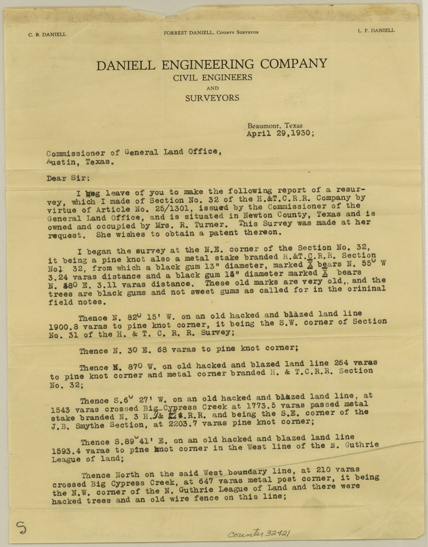
Newton County Sketch File 41
[Sketch and report regarding a resurvey of H. & T. C. R.R. Co. section 32 in the south part of the county]
-
Map/Doc
32421
-
Collection
General Map Collection
-
Object Dates
4/29/1930 (Creation Date)
6/18/1930 (File Date)
8/15/1929 (Survey Date)
-
People and Organizations
C.B. Daniell (Surveyor/Engineer)
-
Counties
Newton
-
Subjects
Surveying Sketch File
-
Height x Width
11.2 x 8.7 inches
28.5 x 22.1 cm
-
Medium
multi-page, multi-format
-
Scale
1" = 400 varas
-
Features
Big Cypress Creek
Part of: General Map Collection
Jeff Davis County Rolled Sketch 27

Print $20.00
- Digital $50.00
Jeff Davis County Rolled Sketch 27
1969
Size 29.3 x 36.8 inches
Map/Doc 6375
Amistad International Reservoir on Rio Grande 100

Print $20.00
- Digital $50.00
Amistad International Reservoir on Rio Grande 100
1950
Size 28.5 x 40.8 inches
Map/Doc 75531
Crane County Working Sketch 6

Print $40.00
- Digital $50.00
Crane County Working Sketch 6
1928
Size 92.2 x 25.3 inches
Map/Doc 68283
Map of Hale and Floyd, Lubbock and Crosby Counties

Print $40.00
- Digital $50.00
Map of Hale and Floyd, Lubbock and Crosby Counties
1892
Size 53.0 x 41.3 inches
Map/Doc 2919
Moore County Working Sketch 4

Print $20.00
- Digital $50.00
Moore County Working Sketch 4
1911
Size 20.1 x 15.6 inches
Map/Doc 71186
Uvalde County Working Sketch 65

Print $20.00
- Digital $50.00
Uvalde County Working Sketch 65
Size 34.8 x 43.0 inches
Map/Doc 69696
Gregg County Sketch File 4a

Print $4.00
- Digital $50.00
Gregg County Sketch File 4a
1848
Size 12.7 x 8.1 inches
Map/Doc 24572
Presidio County Working Sketch 97

Print $20.00
- Digital $50.00
Presidio County Working Sketch 97
1978
Size 28.2 x 28.0 inches
Map/Doc 71774
Anderson County Working Sketch 11a

Print $40.00
- Digital $50.00
Anderson County Working Sketch 11a
1933
Size 42.7 x 64.2 inches
Map/Doc 67011
Upton County Working Sketch 5

Print $20.00
- Digital $50.00
Upton County Working Sketch 5
1909
Size 15.9 x 27.1 inches
Map/Doc 69501
Hemphill County

Print $20.00
- Digital $50.00
Hemphill County
1899
Size 43.0 x 36.4 inches
Map/Doc 4976
Harris County Historic Topographic 5

Print $20.00
- Digital $50.00
Harris County Historic Topographic 5
1916
Size 29.2 x 22.8 inches
Map/Doc 65815
You may also like
Section D Tech Memorial Park, Inc.

Print $20.00
- Digital $50.00
Section D Tech Memorial Park, Inc.
Size 19.0 x 20.5 inches
Map/Doc 92300
[A. B. & M. Block 2]
![91794, [A. B. & M. Block 2], Twichell Survey Records](https://historictexasmaps.com/wmedia_w700/maps/91794-1.tif.jpg)
Print $2.00
- Digital $50.00
[A. B. & M. Block 2]
Size 7.1 x 14.1 inches
Map/Doc 91794
Pecos County Sketch File 119

Print $6.00
- Digital $50.00
Pecos County Sketch File 119
1925
Size 11.2 x 8.8 inches
Map/Doc 34111
Cottle County Sketch File G

Print $8.00
- Digital $50.00
Cottle County Sketch File G
Size 11.5 x 7.3 inches
Map/Doc 19447
Red River County Working Sketch 9

Print $20.00
- Digital $50.00
Red River County Working Sketch 9
1920
Size 15.2 x 18.9 inches
Map/Doc 71992
Carta General de la República Mexicana Formada en vista de los datos mas recientes y exactos que se han reunido con tal objeto, y constan en la noticia presentada al Exmo. Sr. Ministro de Fomento, por Antonio García y Cubas

Print $20.00
- Digital $50.00
Carta General de la República Mexicana Formada en vista de los datos mas recientes y exactos que se han reunido con tal objeto, y constan en la noticia presentada al Exmo. Sr. Ministro de Fomento, por Antonio García y Cubas
Size 23.3 x 29.2 inches
Map/Doc 95824
Comanche County Working Sketch 6

Print $20.00
- Digital $50.00
Comanche County Working Sketch 6
1935
Size 26.4 x 17.8 inches
Map/Doc 68140
Presidio County Rolled Sketch 131A

Print $20.00
- Digital $50.00
Presidio County Rolled Sketch 131A
Size 17.7 x 11.9 inches
Map/Doc 10710
Fractional Township No. 7 South Range No. 7 West of the Indian Meridian, Indian Territory

Print $20.00
- Digital $50.00
Fractional Township No. 7 South Range No. 7 West of the Indian Meridian, Indian Territory
1898
Size 19.2 x 24.4 inches
Map/Doc 75168
Montgomery County Boundary File 3

Print $6.00
- Digital $50.00
Montgomery County Boundary File 3
Size 17.0 x 9.9 inches
Map/Doc 57450
Gregg County Working Sketch 10

Print $20.00
- Digital $50.00
Gregg County Working Sketch 10
1939
Size 34.1 x 26.4 inches
Map/Doc 63276
Cameron County Aerial Photograph Index Sheet 8

Print $20.00
- Digital $50.00
Cameron County Aerial Photograph Index Sheet 8
1955
Size 20.4 x 16.1 inches
Map/Doc 83680