Pecos County Sketch File 119
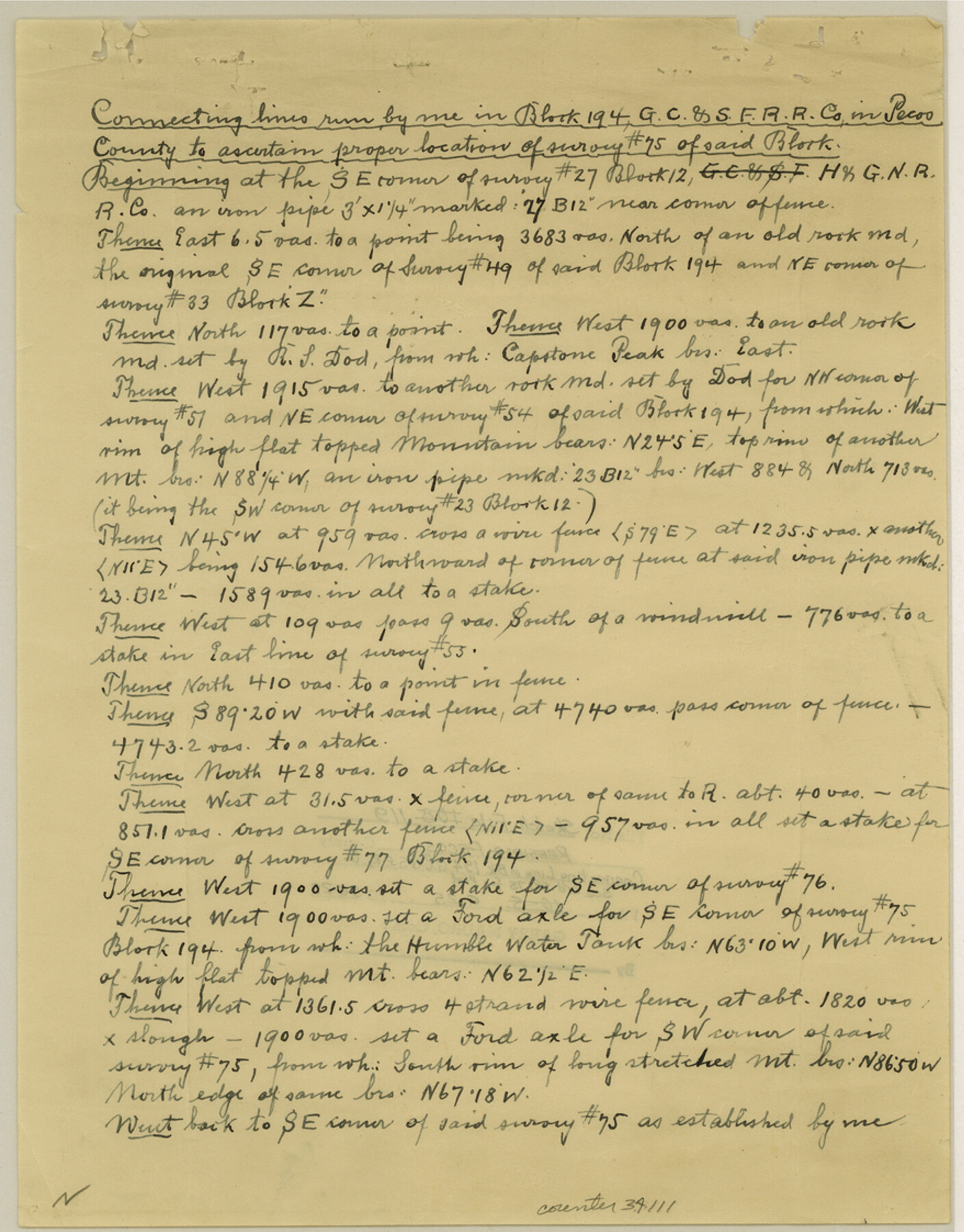
[Connecting lines run in Block 194, G. C. & S. F. RR. Co. to ascertain proper locations of survey 75]
-
Map/Doc
34111
-
Collection
General Map Collection
-
Object Dates
5/1925 (Creation Date)
6/25/1929 (File Date)
5/28/1929 (Survey Date)
-
People and Organizations
M.V. Homeyer (Surveyor/Engineer)
-
Counties
Pecos
-
Subjects
Surveying Sketch File
-
Height x Width
11.2 x 8.8 inches
28.5 x 22.4 cm
-
Medium
paper, manuscript
-
Features
Capstone Peak
Part of: General Map Collection
Flight Mission No. DQO-11K, Frame 21, Galveston County

Print $20.00
- Digital $50.00
Flight Mission No. DQO-11K, Frame 21, Galveston County
1952
Size 18.6 x 19.7 inches
Map/Doc 85218
Sketch A Shewing the progress of the Survey in Section No. 1 From 1844 to 1852

Print $20.00
- Digital $50.00
Sketch A Shewing the progress of the Survey in Section No. 1 From 1844 to 1852
1852
Size 38.1 x 25.3 inches
Map/Doc 97200
Andrews County Sketch File 11

Print $40.00
- Digital $50.00
Andrews County Sketch File 11
1951
Size 12.3 x 25.8 inches
Map/Doc 10811
Mexico, Mittel-America, Texas

Print $20.00
- Digital $50.00
Mexico, Mittel-America, Texas
1850
Size 14.4 x 17.7 inches
Map/Doc 93710
Atascosa County Working Sketch 5

Print $3.00
- Digital $50.00
Atascosa County Working Sketch 5
1913
Size 10.9 x 11.3 inches
Map/Doc 67201
Bowie County Sketch File 1

Print $8.00
- Digital $50.00
Bowie County Sketch File 1
Size 8.6 x 10.0 inches
Map/Doc 14833
Gregg County Working Sketch 8

Print $20.00
- Digital $50.00
Gregg County Working Sketch 8
1936
Size 26.0 x 23.3 inches
Map/Doc 63274
Rockwall County

Print $20.00
- Digital $50.00
Rockwall County
1874
Size 20.3 x 18.6 inches
Map/Doc 3998
Young County Working Sketch 25

Print $20.00
- Digital $50.00
Young County Working Sketch 25
1982
Size 12.6 x 14.4 inches
Map/Doc 62048
San Antonio & Aransas Pass

Print $40.00
- Digital $50.00
San Antonio & Aransas Pass
Size 30.9 x 74.5 inches
Map/Doc 64633
Zavala County Sketch File 2

Print $22.00
- Digital $50.00
Zavala County Sketch File 2
Size 13.2 x 14.4 inches
Map/Doc 41261
Pecos County Sketch File 67

Print $76.00
- Digital $50.00
Pecos County Sketch File 67
1919
Size 14.1 x 8.8 inches
Map/Doc 33828
You may also like
Houston County Sketch File 18

Print $4.00
- Digital $50.00
Houston County Sketch File 18
Size 4.8 x 10.3 inches
Map/Doc 26781
Bastrop County Sketch File 5

Print $4.00
- Digital $50.00
Bastrop County Sketch File 5
Size 8.1 x 10.2 inches
Map/Doc 14048
General Highway Map, Carson County, Texas

Print $20.00
General Highway Map, Carson County, Texas
1940
Size 18.5 x 25.1 inches
Map/Doc 79041
Trace d'une partie Chemin de Fer de Galveston à Houston et Henderson, Texas, Etats unis d'Amérique

Print $20.00
- Digital $50.00
Trace d'une partie Chemin de Fer de Galveston à Houston et Henderson, Texas, Etats unis d'Amérique
1857
Size 17.1 x 21.8 inches
Map/Doc 93905
Sabine River, West Extension Toll Bridge Sheet

Print $4.00
- Digital $50.00
Sabine River, West Extension Toll Bridge Sheet
1933
Size 15.2 x 19.3 inches
Map/Doc 65142
Zavala County Sketch File 25

Print $4.00
- Digital $50.00
Zavala County Sketch File 25
1886
Size 14.5 x 8.8 inches
Map/Doc 41388
Flight Mission No. BRE-3P, Frame 77, Nueces County

Print $20.00
- Digital $50.00
Flight Mission No. BRE-3P, Frame 77, Nueces County
1956
Size 18.6 x 22.6 inches
Map/Doc 86818
[West Central Portion of County]
![91257, [West Central Portion of County], Twichell Survey Records](https://historictexasmaps.com/wmedia_w700/maps/91257-1.tif.jpg)
Print $20.00
- Digital $50.00
[West Central Portion of County]
Size 19.5 x 9.8 inches
Map/Doc 91257
Bandera County Rolled Sketch 2

Print $20.00
- Digital $50.00
Bandera County Rolled Sketch 2
1945
Size 19.1 x 24.0 inches
Map/Doc 5114
Cochran County Sketch File 5

Print $24.00
- Digital $50.00
Cochran County Sketch File 5
1932
Size 11.1 x 8.7 inches
Map/Doc 18542
El Paso County Boundary File 9

Print $14.00
- Digital $50.00
El Paso County Boundary File 9
Size 12.7 x 8.2 inches
Map/Doc 53111
Henderson County Rolled Sketch 1

Print $20.00
- Digital $50.00
Henderson County Rolled Sketch 1
1942
Size 34.0 x 38.3 inches
Map/Doc 9159