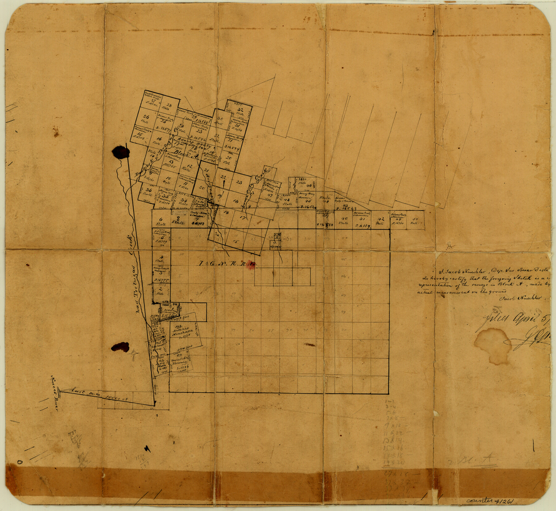
Zavala County Sketch File 2
[Sketch of surveys in Block A northeast from Crystal City]
-
Map/Doc
41261
-
Collection
General Map Collection
-
People and Organizations
Jacob Kuechler (Surveyor/Engineer)
-
Counties
Zavala Dimmit
-
Subjects
Surveying Sketch File
-
Height x Width
13.2 x 14.4 inches
33.5 x 36.6 cm
-
Medium
paper, manuscript
-
Features
East Fork of Tortugas Creek
Loma Vista Creek
Arroyo Negro
Las Tortugas Creek
Nueces River
Part of: General Map Collection
Hockley County Working Sketch Graphic Index

Print $20.00
- Digital $50.00
Hockley County Working Sketch Graphic Index
1954
Size 42.3 x 37.8 inches
Map/Doc 76579
Hudspeth County Rolled Sketch 63

Print $20.00
- Digital $50.00
Hudspeth County Rolled Sketch 63
Size 41.8 x 47.9 inches
Map/Doc 9227
Map of Washburn, Armstrong County, Texas junction of Pan-Handle (Southern Kansas) and Fort Worth & Denver City R'ys

Print $20.00
- Digital $50.00
Map of Washburn, Armstrong County, Texas junction of Pan-Handle (Southern Kansas) and Fort Worth & Denver City R'ys
1888
Map/Doc 97426
Wilson County Boundary File 9

Print $42.00
- Digital $50.00
Wilson County Boundary File 9
Size 14.3 x 8.9 inches
Map/Doc 60119
Washington County Working Sketch 4

Print $20.00
- Digital $50.00
Washington County Working Sketch 4
1992
Size 28.2 x 25.2 inches
Map/Doc 72365
Leon County Working Sketch 19

Print $20.00
- Digital $50.00
Leon County Working Sketch 19
1962
Size 31.2 x 31.4 inches
Map/Doc 70418
Sterling County Sketch File 26

Print $24.00
- Digital $50.00
Sterling County Sketch File 26
1989
Size 14.2 x 8.8 inches
Map/Doc 37194
Flight Mission No. DAH-9M, Frame 200, Orange County

Print $20.00
- Digital $50.00
Flight Mission No. DAH-9M, Frame 200, Orange County
1953
Size 18.6 x 22.4 inches
Map/Doc 86868
Trinity County Sketch File 8

Print $6.00
- Digital $50.00
Trinity County Sketch File 8
1859
Size 12.8 x 7.9 inches
Map/Doc 38513
Montague County Sketch File 6

Print $4.00
- Digital $50.00
Montague County Sketch File 6
1856
Size 8.0 x 8.4 inches
Map/Doc 31717
Gaines County Sketch File 1

Print $20.00
- Digital $50.00
Gaines County Sketch File 1
Size 19.1 x 30.7 inches
Map/Doc 11521
Galveston County NRC Article 33.136 Location Key Sheet

Print $20.00
- Digital $50.00
Galveston County NRC Article 33.136 Location Key Sheet
1994
Size 27.0 x 22.0 inches
Map/Doc 77015
You may also like
Map of surveys 191 & 192 T. C. R.R. Co. in Travis County, Texas

Print $20.00
- Digital $50.00
Map of surveys 191 & 192 T. C. R.R. Co. in Travis County, Texas
1915
Size 20.7 x 12.9 inches
Map/Doc 75555
Flight Mission No. BRA-8M, Frame 64, Jefferson County

Print $20.00
- Digital $50.00
Flight Mission No. BRA-8M, Frame 64, Jefferson County
1953
Size 18.5 x 22.3 inches
Map/Doc 85584
Railroad Track Map, T&PRRCo., Culberson County, Texas

Print $4.00
- Digital $50.00
Railroad Track Map, T&PRRCo., Culberson County, Texas
1910
Size 11.7 x 18.5 inches
Map/Doc 62825
Zapata County

Print $40.00
- Digital $50.00
Zapata County
1935
Size 56.2 x 41.9 inches
Map/Doc 95683

University Land, El Paso County

Print $20.00
- Digital $50.00
University Land, El Paso County
1906
Size 25.1 x 31.4 inches
Map/Doc 2428
Map of University Land in McLennan County

Print $20.00
- Digital $50.00
Map of University Land in McLennan County
1905
Size 35.1 x 32.9 inches
Map/Doc 2432
Current Miscellaneous File 29

Print $10.00
- Digital $50.00
Current Miscellaneous File 29
Size 11.2 x 8.8 inches
Map/Doc 73920
Pecos County Sketch File 28

Print $20.00
- Digital $50.00
Pecos County Sketch File 28
1927
Size 23.4 x 21.6 inches
Map/Doc 12168
Collingsworth County Sketch File 4

Print $20.00
- Digital $50.00
Collingsworth County Sketch File 4
1889
Size 23.4 x 31.3 inches
Map/Doc 11131
Houston County Sketch File 14

Print $6.00
- Digital $50.00
Houston County Sketch File 14
1886
Size 8.8 x 13.0 inches
Map/Doc 26778
Schleicher County Sketch File 14

Print $12.00
- Digital $50.00
Schleicher County Sketch File 14
1917
Size 12.9 x 8.3 inches
Map/Doc 36498