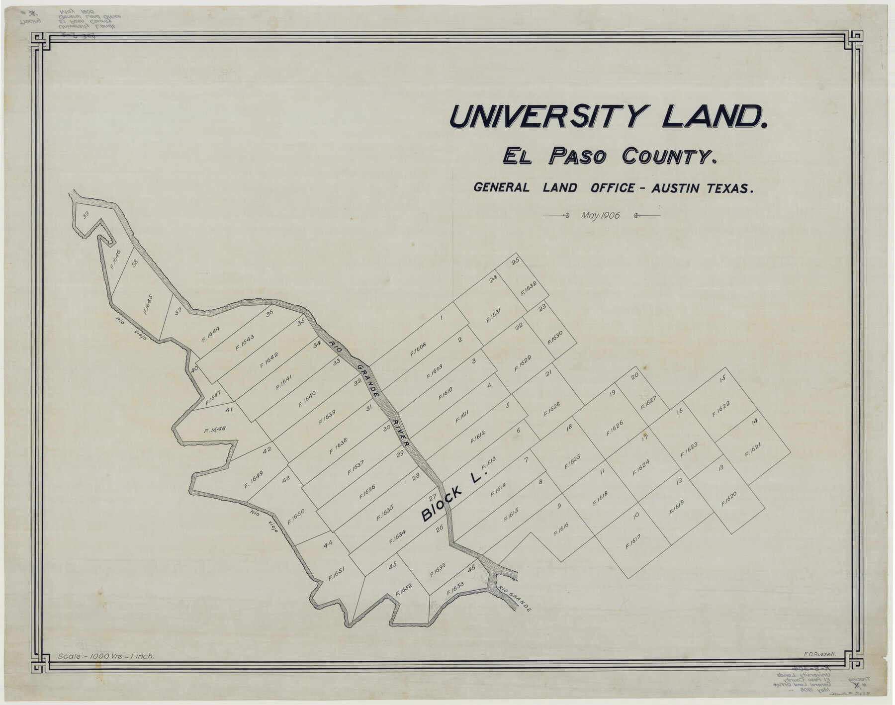
University Land, El Paso County
K-8-304
-
Map/Doc
2428
-
Collection
General Map Collection
-
Object Dates
1906 (Creation Date)
-
People and Organizations
General Land Office (Publisher)
-
Counties
El Paso
-
Subjects
University Land
-
Height x Width
25.1 x 31.4 inches
63.8 x 79.8 cm
Part of: General Map Collection
Parker County

Print $20.00
- Digital $50.00
Parker County
1942
Size 47.7 x 38.9 inches
Map/Doc 95609
Clay County Sketch File 47

Print $6.00
- Digital $50.00
Clay County Sketch File 47
Size 11.3 x 17.4 inches
Map/Doc 18485
Map of the Lands belonging to the Texas Land & Cattle Co. situated in Wharton, Matagorda and Jackson Counties, Texas

Print $20.00
- Digital $50.00
Map of the Lands belonging to the Texas Land & Cattle Co. situated in Wharton, Matagorda and Jackson Counties, Texas
1904
Size 24.6 x 38.5 inches
Map/Doc 94020
Flight Mission No. CRE-2R, Frame 167, Jackson County

Print $20.00
- Digital $50.00
Flight Mission No. CRE-2R, Frame 167, Jackson County
1956
Size 18.6 x 22.4 inches
Map/Doc 85377
Crosby County Boundary File 5a

Print $60.00
- Digital $50.00
Crosby County Boundary File 5a
Size 8.0 x 35.4 inches
Map/Doc 52044
Johnson County Sketch File 10a

Print $4.00
- Digital $50.00
Johnson County Sketch File 10a
1877
Size 6.7 x 10.6 inches
Map/Doc 28445
Glasscock County Sketch File 6

Print $6.00
- Digital $50.00
Glasscock County Sketch File 6
1929
Size 14.8 x 10.9 inches
Map/Doc 24164
Flight Mission No. CRC-6R, Frame 39, Chambers County

Print $20.00
- Digital $50.00
Flight Mission No. CRC-6R, Frame 39, Chambers County
1956
Size 18.7 x 22.5 inches
Map/Doc 84972
Matagorda County NRC Article 33.136 Location Key Sheet

Print $20.00
- Digital $50.00
Matagorda County NRC Article 33.136 Location Key Sheet
1973
Size 27.0 x 23.0 inches
Map/Doc 88832
Kimble County Sketch File 38

Print $10.00
- Digital $50.00
Kimble County Sketch File 38
1989
Size 3.6 x 4.0 inches
Map/Doc 28992
Lamar County Working Sketch 10

Print $20.00
- Digital $50.00
Lamar County Working Sketch 10
1980
Size 18.6 x 15.4 inches
Map/Doc 70271
Maps of Gulf Intracoastal Waterway, Texas - Sabine River to the Rio Grande and connecting waterways including ship channels

Print $20.00
- Digital $50.00
Maps of Gulf Intracoastal Waterway, Texas - Sabine River to the Rio Grande and connecting waterways including ship channels
1966
Size 14.6 x 22.2 inches
Map/Doc 61970
You may also like
Gonzales County

Print $40.00
- Digital $50.00
Gonzales County
1986
Size 41.6 x 54.7 inches
Map/Doc 73160
Bee County Boundary File 7

Print $8.00
- Digital $50.00
Bee County Boundary File 7
Size 12.7 x 8.1 inches
Map/Doc 50460
Live Oak County Sketch File 20

Print $14.00
- Digital $50.00
Live Oak County Sketch File 20
1898
Size 11.4 x 8.8 inches
Map/Doc 30290
Pecos County Rolled Sketch 32

Print $20.00
- Digital $50.00
Pecos County Rolled Sketch 32
1890
Size 21.0 x 14.1 inches
Map/Doc 7214
Travis County Working Sketch 48

Print $40.00
- Digital $50.00
Travis County Working Sketch 48
1981
Size 53.7 x 40.3 inches
Map/Doc 69432
Jefferson County Working Sketch 23

Print $20.00
- Digital $50.00
Jefferson County Working Sketch 23
1970
Size 23.9 x 29.2 inches
Map/Doc 66566
Carson County

Print $20.00
- Digital $50.00
Carson County
1932
Size 43.4 x 38.8 inches
Map/Doc 95449
Bandera County Sketch File 19

Print $40.00
- Digital $50.00
Bandera County Sketch File 19
Size 15.9 x 18.9 inches
Map/Doc 10893
Ochiltree County Working Sketch 6

Print $20.00
- Digital $50.00
Ochiltree County Working Sketch 6
1962
Size 31.1 x 22.9 inches
Map/Doc 71319
Nueces County Rolled Sketch 129 A-C

Print $6.00
- Digital $50.00
Nueces County Rolled Sketch 129 A-C
1998
Size 11.2 x 8.8 inches
Map/Doc 41616
Presidio County Rolled Sketch 34

Print $20.00
- Digital $50.00
Presidio County Rolled Sketch 34
1890
Size 46.1 x 32.9 inches
Map/Doc 9773
Young County Working Sketch 6

Print $20.00
- Digital $50.00
Young County Working Sketch 6
1919
Size 12.2 x 11.9 inches
Map/Doc 62029