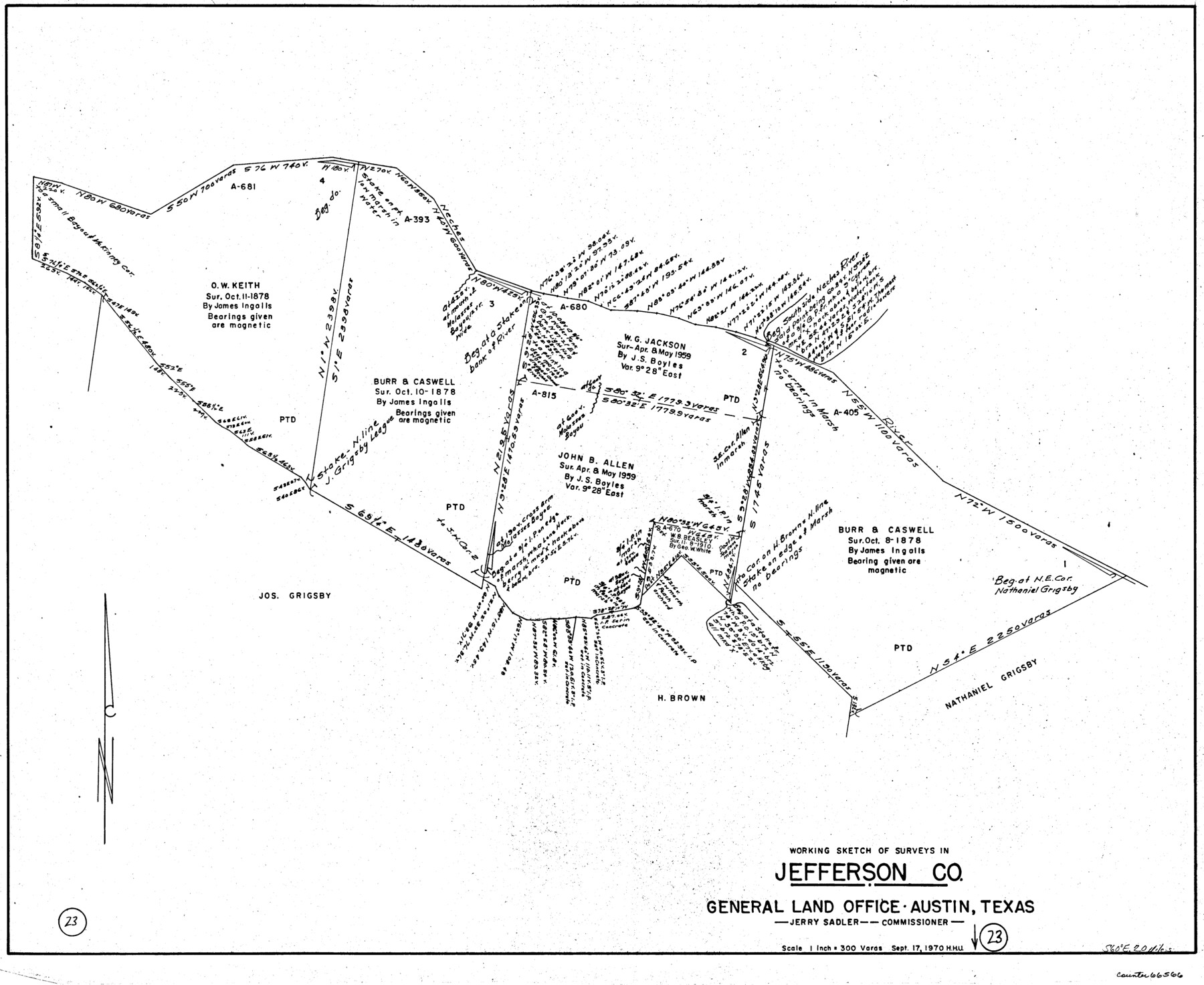
Jefferson County Working Sketch 23
-
Map/Doc
66566
-
Collection
General Map Collection
-
Object Dates
9/17/1970 (Creation Date)
-
People and Organizations
Herbert H. Ulbricht (Draftsman)
-
Counties
Jefferson
-
Subjects
Surveying Working Sketch
-
Height x Width
23.9 x 29.2 inches
60.7 x 74.2 cm
-
Scale
1" = 300 varas
Part of: General Map Collection
Ashburn's San Antonio City Map

Ashburn's San Antonio City Map
1951
Size 24.5 x 19.5 inches
Map/Doc 97144
Preliminary Chart of Galveston Bay, Texas

Print $20.00
- Digital $50.00
Preliminary Chart of Galveston Bay, Texas
1855
Size 20.9 x 17.5 inches
Map/Doc 69868
Brooks County Working Sketch 8

Print $20.00
- Digital $50.00
Brooks County Working Sketch 8
1928
Size 27.6 x 23.3 inches
Map/Doc 67792
Motley County Boundary File 2e

Print $40.00
- Digital $50.00
Motley County Boundary File 2e
Size 29.4 x 96.1 inches
Map/Doc 57561
Comal County Working Sketch 15

Print $20.00
- Digital $50.00
Comal County Working Sketch 15
1994
Size 44.6 x 31.0 inches
Map/Doc 68181
Kleberg County Rolled Sketch 10-29

Print $20.00
- Digital $50.00
Kleberg County Rolled Sketch 10-29
1952
Size 37.6 x 33.8 inches
Map/Doc 9373
Red River County Sketch File 3

Print $4.00
- Digital $50.00
Red River County Sketch File 3
Size 10.4 x 8.3 inches
Map/Doc 35098
Right of Way and Track Map Houston & Texas Central R.R. operated by the T. and N. O. R.R. Co., Fort Worth Branch

Print $40.00
- Digital $50.00
Right of Way and Track Map Houston & Texas Central R.R. operated by the T. and N. O. R.R. Co., Fort Worth Branch
1918
Size 31.3 x 57.1 inches
Map/Doc 64539
New Counties in the Panhandle

Print $20.00
- Digital $50.00
New Counties in the Panhandle
Size 24.4 x 21.3 inches
Map/Doc 69765
Pecos County Sketch File 96

Print $40.00
- Digital $50.00
Pecos County Sketch File 96
1957
Size 22.4 x 8.7 inches
Map/Doc 33998
Wichita County Boundary File 5

Print $20.00
- Digital $50.00
Wichita County Boundary File 5
Size 11.0 x 38.5 inches
Map/Doc 59915
Travis County Sketch File 28

Print $40.00
- Digital $50.00
Travis County Sketch File 28
Size 17.5 x 12.2 inches
Map/Doc 38341
You may also like
[Right of Way & Track Map, The Texas & Pacific Ry. Co. Main Line]
![64691, [Right of Way & Track Map, The Texas & Pacific Ry. Co. Main Line], General Map Collection](https://historictexasmaps.com/wmedia_w700/maps/64691.tif.jpg)
Print $20.00
- Digital $50.00
[Right of Way & Track Map, The Texas & Pacific Ry. Co. Main Line]
Size 10.9 x 18.6 inches
Map/Doc 64691
Van Zandt County Sketch File 32

Print $4.00
- Digital $50.00
Van Zandt County Sketch File 32
1860
Size 12.2 x 7.9 inches
Map/Doc 39465
Bee County Sketch File 20

Print $8.00
- Digital $50.00
Bee County Sketch File 20
1861
Size 14.3 x 8.8 inches
Map/Doc 14308
Montgomery County Sketch File 17

Print $42.00
- Digital $50.00
Montgomery County Sketch File 17
1912
Size 8.6 x 7.8 inches
Map/Doc 31832
Parker County Sketch File 45

Print $10.00
- Digital $50.00
Parker County Sketch File 45
1935
Size 11.0 x 8.5 inches
Map/Doc 33610
Val Verde County

Print $20.00
- Digital $50.00
Val Verde County
1944
Size 41.3 x 36.6 inches
Map/Doc 95661
Lamb County Sketch File 1 and 1a

Print $30.00
- Digital $50.00
Lamb County Sketch File 1 and 1a
Size 8.7 x 7.6 inches
Map/Doc 29337

Montgomery County Working Sketch 60

Print $20.00
- Digital $50.00
Montgomery County Working Sketch 60
1963
Size 24.3 x 42.7 inches
Map/Doc 71167
Glasscock County

Print $20.00
- Digital $50.00
Glasscock County
1933
Size 46.2 x 38.6 inches
Map/Doc 95508
Gregg County Sketch File 16

Print $6.00
- Digital $50.00
Gregg County Sketch File 16
1931
Size 17.0 x 11.0 inches
Map/Doc 24619
Index sheet to accompany map of survey for connecting the inland waters along margin of the Gulf of Mexico from Donaldsonville in Louisiana to the Rio Grande River in Texas

Print $20.00
- Digital $50.00
Index sheet to accompany map of survey for connecting the inland waters along margin of the Gulf of Mexico from Donaldsonville in Louisiana to the Rio Grande River in Texas
Size 18.2 x 27.5 inches
Map/Doc 72691