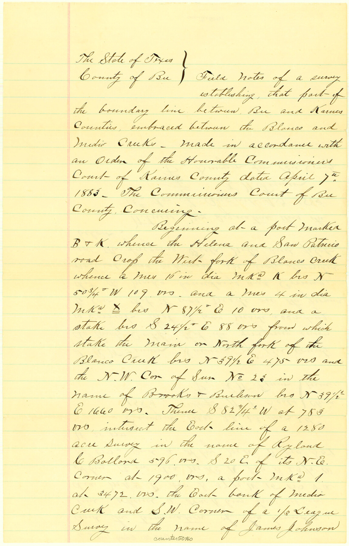
Bee County Boundary File 7
Field Notes of a survey establishing that part of the boundary line between Bee and Karnes Counties, embraced between the Blanco and Medio Creeks
-
Map/Doc
50460
-
Collection
General Map Collection
-
Counties
Bee
-
Subjects
County Boundaries
-
Height x Width
12.7 x 8.1 inches
32.3 x 20.6 cm
Part of: General Map Collection
Coast Chart No. 211 - Padre I. and Laguna Madre Lat. 27° 12' to Lat. 26° 33' Texas

Print $20.00
- Digital $50.00
Coast Chart No. 211 - Padre I. and Laguna Madre Lat. 27° 12' to Lat. 26° 33' Texas
1890
Size 27.5 x 18.2 inches
Map/Doc 72822
Pecos County Rolled Sketch 164

Print $20.00
- Digital $50.00
Pecos County Rolled Sketch 164
1965
Size 30.2 x 20.1 inches
Map/Doc 7287
Matagorda Bay Including Lavaca and Tres Palacios Bays

Print $40.00
- Digital $50.00
Matagorda Bay Including Lavaca and Tres Palacios Bays
1973
Size 37.0 x 48.4 inches
Map/Doc 73363
Flight Mission No. DCL-7C, Frame 139, Kenedy County

Print $20.00
- Digital $50.00
Flight Mission No. DCL-7C, Frame 139, Kenedy County
1943
Size 18.5 x 22.3 inches
Map/Doc 86096
Kent County Working Sketch 2

Print $20.00
- Digital $50.00
Kent County Working Sketch 2
1947
Size 43.7 x 42.7 inches
Map/Doc 70008
Brazoria County NRC Article 33.136 Sketch 17

Print $88.00
- Digital $50.00
Brazoria County NRC Article 33.136 Sketch 17
2015
Size 22.0 x 34.0 inches
Map/Doc 95020
Concho County Sketch File 31

Print $30.00
- Digital $50.00
Concho County Sketch File 31
1911
Size 11.2 x 9.0 inches
Map/Doc 19175
Calhoun County Rolled Sketch 18

Print $20.00
- Digital $50.00
Calhoun County Rolled Sketch 18
1952
Size 12.2 x 11.9 inches
Map/Doc 5371
Franklin County Sketch File 16

Print $6.00
- Digital $50.00
Franklin County Sketch File 16
Size 13.2 x 8.2 inches
Map/Doc 23023
Edwards County

Print $40.00
- Digital $50.00
Edwards County
1900
Size 47.7 x 59.8 inches
Map/Doc 82082
Upshur County Sketch File 6

Print $4.00
- Digital $50.00
Upshur County Sketch File 6
1855
Size 8.7 x 13.0 inches
Map/Doc 38742
Map of Haskell County Young District

Print $20.00
- Digital $50.00
Map of Haskell County Young District
1859
Size 21.9 x 25.8 inches
Map/Doc 3641
You may also like
Crockett County Rolled Sketch 96

Print $20.00
- Digital $50.00
Crockett County Rolled Sketch 96
1986
Size 25.2 x 28.9 inches
Map/Doc 5635
G. C. & S. F. Ry. Northern-Division, Alignment and Right of Way Map, Weatherford Branch, Johnson and Hood Counties, Texas

Print $40.00
- Digital $50.00
G. C. & S. F. Ry. Northern-Division, Alignment and Right of Way Map, Weatherford Branch, Johnson and Hood Counties, Texas
1935
Size 37.8 x 100.5 inches
Map/Doc 64649
Flight Mission No. DAH-17M, Frame 65, Orange County

Print $20.00
- Digital $50.00
Flight Mission No. DAH-17M, Frame 65, Orange County
1953
Size 18.8 x 22.5 inches
Map/Doc 86899
Flight Mission No. DCL-6C, Frame 3, Kenedy County

Print $20.00
- Digital $50.00
Flight Mission No. DCL-6C, Frame 3, Kenedy County
1943
Size 18.8 x 22.5 inches
Map/Doc 85863
Lampasas County Sketch File 3

Print $4.00
- Digital $50.00
Lampasas County Sketch File 3
1856
Size 12.1 x 7.6 inches
Map/Doc 29392
English Field Notes of the Spanish Archives - Book C

English Field Notes of the Spanish Archives - Book C
1835
Map/Doc 96541
Flight Mission No. DCL-7C, Frame 110, Kenedy County

Print $20.00
- Digital $50.00
Flight Mission No. DCL-7C, Frame 110, Kenedy County
1943
Size 18.5 x 22.3 inches
Map/Doc 86075
[Galveston, Harrisburg & San Antonio through El Paso County]
![64006, [Galveston, Harrisburg & San Antonio through El Paso County], General Map Collection](https://historictexasmaps.com/wmedia_w700/maps/64006.tif.jpg)
Print $20.00
- Digital $50.00
[Galveston, Harrisburg & San Antonio through El Paso County]
Size 13.5 x 33.7 inches
Map/Doc 64006
Flight Mission No. CRC-4R, Frame 180, Chambers County

Print $20.00
- Digital $50.00
Flight Mission No. CRC-4R, Frame 180, Chambers County
1956
Size 18.6 x 22.2 inches
Map/Doc 84931
Culberson County Sketch File 2a

Print $20.00
- Digital $50.00
Culberson County Sketch File 2a
1849
Size 20.0 x 14.7 inches
Map/Doc 4852
Official Map of the Highway System of Texas

Print $20.00
- Digital $50.00
Official Map of the Highway System of Texas
1936
Size 27.5 x 33.4 inches
Map/Doc 83598
Briscoe County Sketch File 9

Print $40.00
- Digital $50.00
Briscoe County Sketch File 9
1896
Size 31.9 x 27.2 inches
Map/Doc 10996