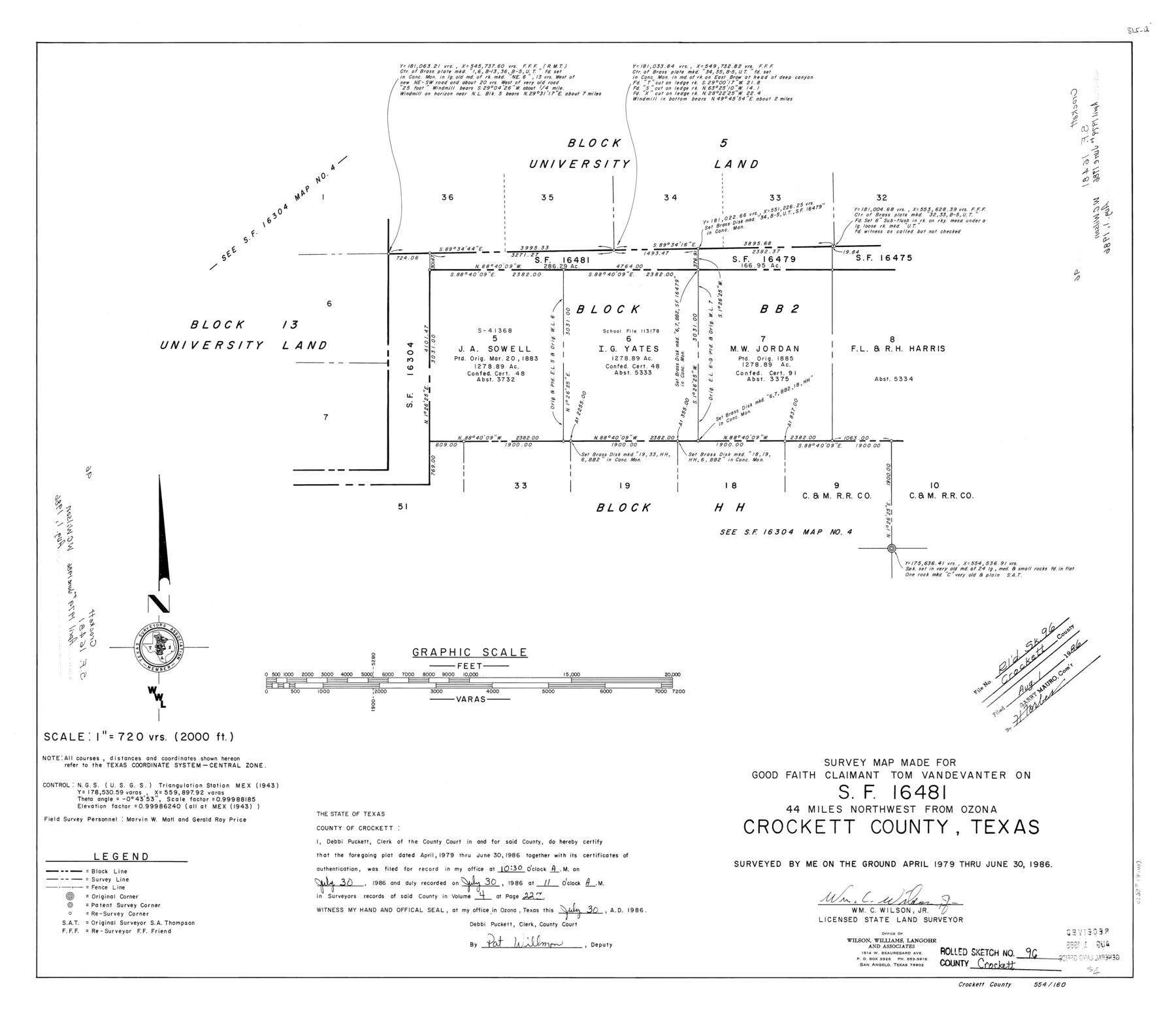
Crockett County Rolled Sketch 96
Survey map made for Good Faith Claimant Tom Vandevanter on SF-16481
-
Map/Doc
5635
-
Collection
General Map Collection
-
Object Dates
1986/6/30 (Creation Date)
1986/8/1 (File Date)
-
People and Organizations
Wm. C. Wilson, Jr. (Surveyor/Engineer)
-
Counties
Crockett
-
Subjects
Surveying Rolled Sketch
-
Height x Width
25.2 x 28.9 inches
64.0 x 73.4 cm
-
Scale
1" = 720 varas
Part of: General Map Collection
Pecos County Sketch File 85

Print $19.00
- Digital $50.00
Pecos County Sketch File 85
1948
Size 14.6 x 9.2 inches
Map/Doc 33955
Roberts County Sketch File 6

Print $6.00
- Digital $50.00
Roberts County Sketch File 6
1935
Size 10.8 x 14.5 inches
Map/Doc 35314
Crockett County Rolled Sketch 46

Print $20.00
- Digital $50.00
Crockett County Rolled Sketch 46
1938
Size 46.0 x 43.0 inches
Map/Doc 8711
Robertson County Sketch File 12

Print $18.00
Robertson County Sketch File 12
1987
Size 11.4 x 8.8 inches
Map/Doc 35404
Jefferson County NRC Article 33.136 Sketch 14

Print $164.00
- Digital $50.00
Jefferson County NRC Article 33.136 Sketch 14
2021
Map/Doc 96645
Map of Madison County

Print $20.00
- Digital $50.00
Map of Madison County
1880
Size 17.0 x 24.9 inches
Map/Doc 3832
Jefferson County Sketch File 4

Print $4.00
- Digital $50.00
Jefferson County Sketch File 4
Size 13.0 x 8.3 inches
Map/Doc 28101
Industrial Site, Imperial State Prison Farm, Sugarland, Texas

Print $20.00
- Digital $50.00
Industrial Site, Imperial State Prison Farm, Sugarland, Texas
Size 26.6 x 27.5 inches
Map/Doc 73562
Crockett County Working Sketch 69

Print $20.00
- Digital $50.00
Crockett County Working Sketch 69
1962
Size 34.8 x 45.5 inches
Map/Doc 68402
Atascosa County Sketch File 40

Print $40.00
- Digital $50.00
Atascosa County Sketch File 40
1881
Size 15.2 x 12.6 inches
Map/Doc 13835
[Galveston, Harrisburg & San Antonio Railroad from Cuero to Stockdale]
![64186, [Galveston, Harrisburg & San Antonio Railroad from Cuero to Stockdale], General Map Collection](https://historictexasmaps.com/wmedia_w700/maps/64186.tif.jpg)
Print $20.00
- Digital $50.00
[Galveston, Harrisburg & San Antonio Railroad from Cuero to Stockdale]
1906
Size 13.4 x 33.1 inches
Map/Doc 64186
Goliad County Sketch File 38

Print $4.00
- Digital $50.00
Goliad County Sketch File 38
1859
Size 13.0 x 8.1 inches
Map/Doc 24338
You may also like
State of Texas, Wheeler County, Surveys 37-44-46, Block 17

Print $20.00
- Digital $50.00
State of Texas, Wheeler County, Surveys 37-44-46, Block 17
Size 19.4 x 13.0 inches
Map/Doc 92115
Rusk County Working Sketch 30

Print $20.00
- Digital $50.00
Rusk County Working Sketch 30
1931
Size 22.9 x 21.4 inches
Map/Doc 63667
Presidio County Rolled Sketch 131A

Print $3.00
- Digital $50.00
Presidio County Rolled Sketch 131A
Size 15.8 x 9.3 inches
Map/Doc 10708
Pecos County Working Sketch 84

Print $20.00
- Digital $50.00
Pecos County Working Sketch 84
1961
Size 26.1 x 23.0 inches
Map/Doc 71556
Pecos County Rolled Sketch DK2

Print $20.00
- Digital $50.00
Pecos County Rolled Sketch DK2
1938
Size 31.8 x 40.0 inches
Map/Doc 9714
Harris County Sketch File 56a

Print $54.00
- Digital $50.00
Harris County Sketch File 56a
1912
Size 9.0 x 7.9 inches
Map/Doc 25456
Cottle County Sketch File 16

Print $8.00
- Digital $50.00
Cottle County Sketch File 16
1911
Size 10.7 x 8.7 inches
Map/Doc 19518
Edwards County Sketch File 15

Print $10.00
- Digital $50.00
Edwards County Sketch File 15
1893
Size 12.9 x 8.5 inches
Map/Doc 21715
Terrell County Working Sketch 72

Print $20.00
- Digital $50.00
Terrell County Working Sketch 72
1980
Size 14.3 x 24.8 inches
Map/Doc 69593
Llano County Working Sketch 3

Print $20.00
- Digital $50.00
Llano County Working Sketch 3
1949
Size 23.6 x 24.0 inches
Map/Doc 70621
Bird's Eye View of San Marcos, Hays County, Texas

Print $20.00
Bird's Eye View of San Marcos, Hays County, Texas
1881
Size 18.5 x 28.3 inches
Map/Doc 89205
Edwards County Working Sketch 40

Print $20.00
- Digital $50.00
Edwards County Working Sketch 40
1949
Size 19.8 x 18.6 inches
Map/Doc 68916