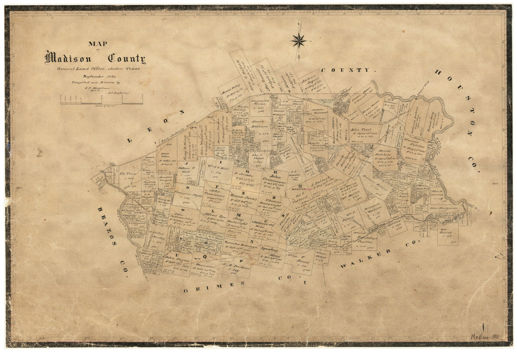
Map of Madison County
-
Map/Doc
3832
-
Collection
General Map Collection
-
Object Dates
9/1880 (Creation Date)
-
People and Organizations
Texas General Land Office (Publisher)
Sam. P. Matthews (Draftsman)
Sam. P. Matthews (Compiler)
-
Counties
Madison
-
Subjects
County
-
Height x Width
17.0 x 24.9 inches
43.2 x 63.3 cm
-
Features
Robbins' Ferry
San Antonio Road
La Bradie Road
Caney Creek
Brushy Creek
Madisonville
Larrison's Creek
Trinity River
Bidais Creek
Pool's Creek
Collards Creek
Navasota River
Shepherd's Creek
Prewitt's Creek
York's Creek
Part of: General Map Collection
Kendall County Sketch File 25

Print $6.00
- Digital $50.00
Kendall County Sketch File 25
1950
Size 11.2 x 8.6 inches
Map/Doc 28722
Bowie County Working Sketch 14

Print $20.00
- Digital $50.00
Bowie County Working Sketch 14
1959
Size 25.7 x 43.2 inches
Map/Doc 67418
Karnes County Boundary File 5

Print $32.00
- Digital $50.00
Karnes County Boundary File 5
Size 12.7 x 8.2 inches
Map/Doc 55705
Map of Harrison County

Print $20.00
- Digital $50.00
Map of Harrison County
1911
Size 43.8 x 39.8 inches
Map/Doc 4698
Zapata County Rolled Sketch 21

Print $155.00
- Digital $50.00
Zapata County Rolled Sketch 21
Size 10.4 x 15.2 inches
Map/Doc 49589

Jim Hogg County Sketch File 5

Print $20.00
- Digital $50.00
Jim Hogg County Sketch File 5
1939
Size 24.8 x 19.9 inches
Map/Doc 11885
McMullen County Sketch File 20

Print $4.00
- Digital $50.00
McMullen County Sketch File 20
Size 8.1 x 10.0 inches
Map/Doc 31373
Deaf Smith County Working Sketch 2

Print $20.00
- Digital $50.00
Deaf Smith County Working Sketch 2
1926
Size 42.3 x 33.1 inches
Map/Doc 68642
Val Verde County Working Sketch 120

Print $40.00
- Digital $50.00
Val Verde County Working Sketch 120
2005
Size 30.7 x 50.0 inches
Map/Doc 83589
Tom Green County Working Sketch 8

Print $20.00
- Digital $50.00
Tom Green County Working Sketch 8
1950
Size 24.8 x 20.9 inches
Map/Doc 69377
Galveston County Rolled Sketch 17

Print $20.00
- Digital $50.00
Galveston County Rolled Sketch 17
1940
Size 40.4 x 35.4 inches
Map/Doc 9079
You may also like
Hutchinson County Working Sketch 11

Print $20.00
- Digital $50.00
Hutchinson County Working Sketch 11
1924
Size 20.4 x 29.4 inches
Map/Doc 66369
Flight Mission No. DIX-8P, Frame 83, Aransas County

Print $20.00
- Digital $50.00
Flight Mission No. DIX-8P, Frame 83, Aransas County
1956
Size 18.6 x 22.3 inches
Map/Doc 83908
[Shelby District]
![69740, [Shelby District], General Map Collection](https://historictexasmaps.com/wmedia_w700/maps/69740.tif.jpg)
Print $2.00
- Digital $50.00
[Shelby District]
1845
Size 6.9 x 7.6 inches
Map/Doc 69740
Brewster County Rolled Sketch 8

Print $40.00
- Digital $50.00
Brewster County Rolled Sketch 8
1878
Size 60.3 x 35.8 inches
Map/Doc 8467
Map of Mason County

Print $20.00
- Digital $50.00
Map of Mason County
1859
Size 28.4 x 22.4 inches
Map/Doc 3838
Calhoun County Boundary File 4

Print $96.00
- Digital $50.00
Calhoun County Boundary File 4
Size 14.3 x 8.7 inches
Map/Doc 50979
[West Part of Labor 18]
![91006, [West Part of Labor 18], Twichell Survey Records](https://historictexasmaps.com/wmedia_w700/maps/91006-1.tif.jpg)
Print $20.00
- Digital $50.00
[West Part of Labor 18]
Size 18.9 x 19.4 inches
Map/Doc 91006
Lamb County Sketch File 12

Print $16.00
- Digital $50.00
Lamb County Sketch File 12
Size 8.6 x 7.7 inches
Map/Doc 29363
[Bastrop District]
![3131, [Bastrop District], General Map Collection](https://historictexasmaps.com/wmedia_w700/maps/3131.tif.jpg)
Print $40.00
- Digital $50.00
[Bastrop District]
1895
Size 36.5 x 52.0 inches
Map/Doc 3131
Harris County Historic Topographic 25

Print $20.00
- Digital $50.00
Harris County Historic Topographic 25
1916
Size 29.2 x 22.7 inches
Map/Doc 65836
Abandoned and Canceled Surveys - Volume 3 of 3, Counties L-Z

Abandoned and Canceled Surveys - Volume 3 of 3, Counties L-Z
Map/Doc 83250
Llano County Working Sketch 1

Print $20.00
- Digital $50.00
Llano County Working Sketch 1
1938
Size 19.5 x 19.2 inches
Map/Doc 70619