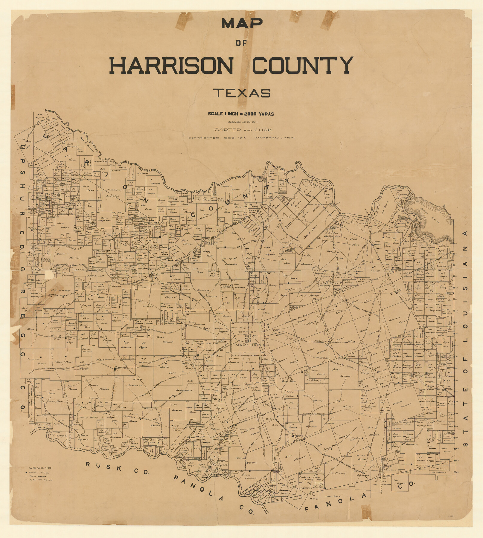
Map of Harrison County
-
Map/Doc
4698
-
Collection
General Map Collection
-
Object Dates
12/1911 (Creation Date)
-
People and Organizations
Carter and Cook of Marshall, Texas (Publisher)
Carter and Cook (Compiler)
-
Counties
Harrison
-
Subjects
County
-
Height x Width
43.8 x 39.8 inches
111.3 x 101.1 cm
-
Features
Short Line Road
Marshall and Jonesville Road
Marshall and Port Caddo Road
Scottsville and Port Caddo Road
Prewitt Creek
Haggerty Creek
Lake Cooper Road
Upper Port Caddo Road
Marshall and Elysian Fields Road
Camdem and Shreveport Road
Feutral
Scottsville
Quapaw Creek
Marshall and Board Ferry Road
Marshall and Carthage Road
Rosborough Springs
Rosborough Springs
Marshall and Rosborough Springs Road
Fire Notch Road
Marshall and Ewing Chapel Road
Marshall
Old Marshall and Jefferson Road
Jonesville
Eight Mile Creek
Camden Road
Marshall to Camden Road
Leigh
Highland Lake
Caddo Road
Shreveport Road
Gilmer Road
Jefferson Road
Waskon
Marshall and Jefferson Road
Jonesville and Swanson Landing Road
Marshall Road
Village Creek
Waskon and Elysian Fields Road
Coffeville Road
Elysian Fields
Blocker
Caney Creek
Caddo Creek
Shreveport and Jefferson Road
Longview and Harlton Road
Moccasin Creek
Marshall and Gilmer Road
Karnack
Marshall and Coffeville Road
Norwood
Port Caddo
Caddo Lake
Ray's Bluff
Midland Lake
Marshall and Noon Day Road
Woodlawn
Gilmer to Renton Road
Little Cypress Bayou
T&P
Jefferson
Jefferson to Gilmer Road
Big Cypress Bayou
Orr City
M&ET
MK&T
Harleton
Marshall to Cypress Road
Gilmer and Denton Road
Marshall and Shreveport Road
Rays Creek
Carter Ferry Road
Potters Creek
Carters Ferry
Rock Ferry Road
Hatler Creek
Pine Ridge
P&IO
Hallville and Harleton Road
Hallville
Mason Creek
Marshall and Henderson Road
Hallville and Camden Road
Ashland
Sabine River
T&G
Marshall and Longview Road
Part of: General Map Collection
Hudspeth County Working Sketch 32

Print $20.00
- Digital $50.00
Hudspeth County Working Sketch 32
1972
Size 21.6 x 31.7 inches
Map/Doc 66316
Bosque County Sketch File 18

Print $4.00
- Digital $50.00
Bosque County Sketch File 18
1863
Size 13.5 x 8.4 inches
Map/Doc 14792
Terrell County Rolled Sketch 43

Print $20.00
- Digital $50.00
Terrell County Rolled Sketch 43
1950
Size 27.5 x 36.4 inches
Map/Doc 7946
Dimmit County Working Sketch 9

Print $20.00
- Digital $50.00
Dimmit County Working Sketch 9
1934
Size 36.3 x 42.2 inches
Map/Doc 68670
Walker County

Print $20.00
- Digital $50.00
Walker County
1944
Size 46.1 x 38.2 inches
Map/Doc 95664
Dimmit County Sketch File 45

Print $20.00
- Digital $50.00
Dimmit County Sketch File 45
1905
Size 24.9 x 25.5 inches
Map/Doc 11355
Eastland County Working Sketch 56

Print $20.00
- Digital $50.00
Eastland County Working Sketch 56
1984
Size 39.2 x 43.3 inches
Map/Doc 68837
Hopkins County Sketch File 10a

Print $4.00
- Digital $50.00
Hopkins County Sketch File 10a
1856
Size 12.2 x 7.8 inches
Map/Doc 26702
Kent County Boundary File 10

Print $16.00
- Digital $50.00
Kent County Boundary File 10
Size 14.0 x 8.8 inches
Map/Doc 55887
Upton County Sketch File 23

Print $4.00
- Digital $50.00
Upton County Sketch File 23
1927
Size 23.8 x 25.7 inches
Map/Doc 12519
Mason County Boundary File 1

Print $2.00
- Digital $50.00
Mason County Boundary File 1
Size 12.7 x 8.2 inches
Map/Doc 56829
Grayson County Working Sketch 10

Print $20.00
- Digital $50.00
Grayson County Working Sketch 10
1951
Size 41.6 x 37.8 inches
Map/Doc 63249
You may also like
Crosby County Sketch File 20

Print $20.00
- Digital $50.00
Crosby County Sketch File 20
Size 25.9 x 18.3 inches
Map/Doc 11252
Flight Mission No. DQO-2K, Frame 160, Galveston County

Print $20.00
- Digital $50.00
Flight Mission No. DQO-2K, Frame 160, Galveston County
1952
Size 18.7 x 22.4 inches
Map/Doc 85049
Denton County Working Sketch 32

Print $20.00
- Digital $50.00
Denton County Working Sketch 32
Size 35.1 x 32.0 inches
Map/Doc 68637

Sabine Bank to East Bay including Heald Bank

Print $20.00
- Digital $50.00
Sabine Bank to East Bay including Heald Bank
1982
Size 44.8 x 34.3 inches
Map/Doc 69852
Fractional Township No. 8 South Range No. 2 West of the Indian Meridian, Indian Territory

Print $20.00
- Digital $50.00
Fractional Township No. 8 South Range No. 2 West of the Indian Meridian, Indian Territory
1898
Size 19.2 x 24.4 inches
Map/Doc 75196
Bowie County Boundary File 72 (23)

Print $10.00
- Digital $50.00
Bowie County Boundary File 72 (23)
Size 13.0 x 8.0 inches
Map/Doc 50694
Sabine Pass and Lake

Print $20.00
- Digital $50.00
Sabine Pass and Lake
1971
Size 47.0 x 27.5 inches
Map/Doc 69825
Flight Mission No. DIX-8P, Frame 85, Aransas County

Print $20.00
- Digital $50.00
Flight Mission No. DIX-8P, Frame 85, Aransas County
1956
Size 18.4 x 19.0 inches
Map/Doc 83910
Flight Mission No. CGI-4N, Frame 192, Cameron County

Print $20.00
- Digital $50.00
Flight Mission No. CGI-4N, Frame 192, Cameron County
1955
Size 18.6 x 22.2 inches
Map/Doc 84695
Matagorda County Sketch File 36

Print $6.00
- Digital $50.00
Matagorda County Sketch File 36
Size 12.1 x 8.3 inches
Map/Doc 30827
