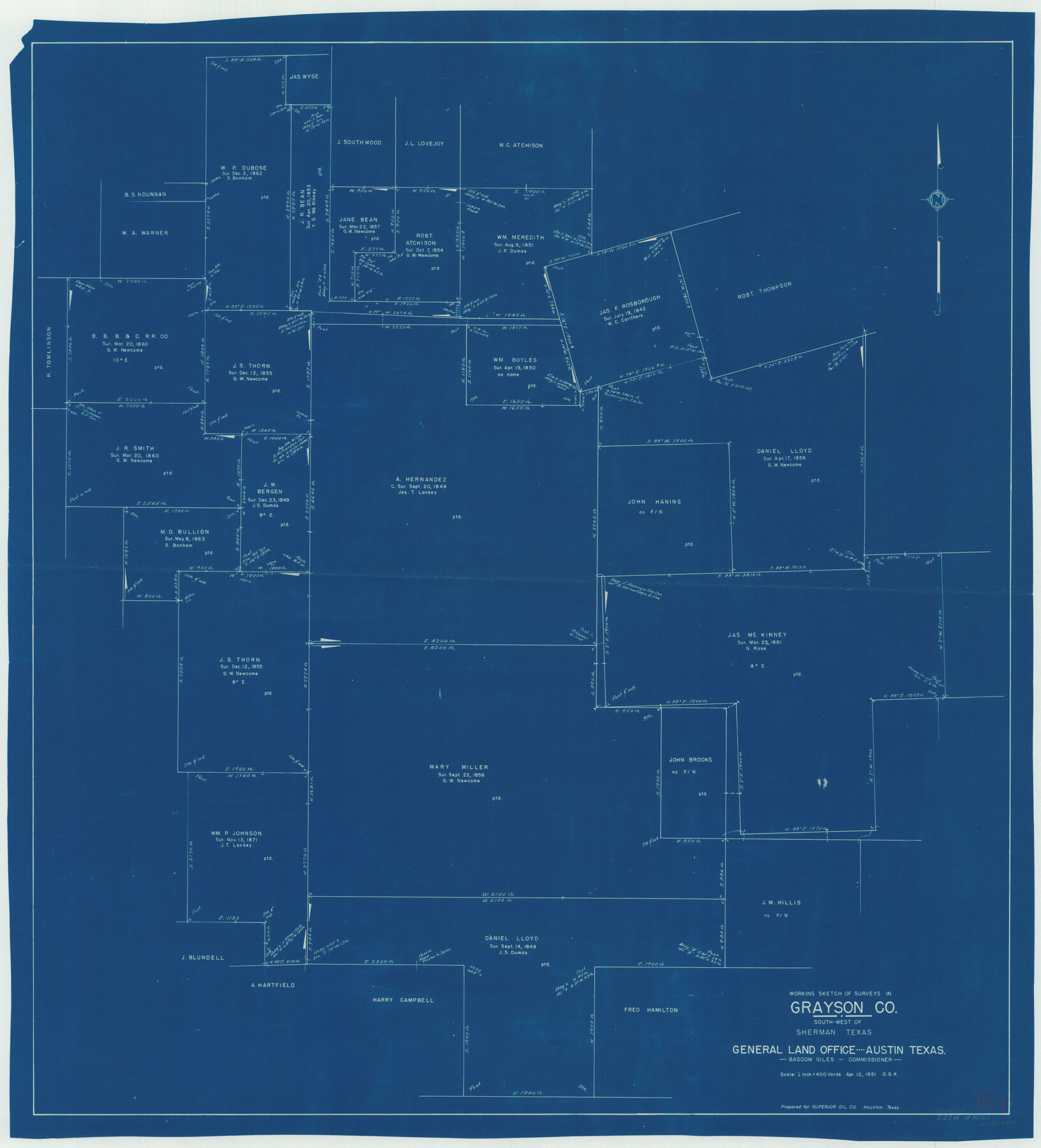
Grayson County Working Sketch 10
-
Map/Doc
63249
-
Collection
General Map Collection
-
Object Dates
4/12/1951 (Creation Date)
-
People and Organizations
Otto G. Kurio (Draftsman)
-
Counties
Grayson
-
Subjects
Surveying Working Sketch
-
Height x Width
41.6 x 37.8 inches
105.7 x 96.0 cm
-
Scale
1" = 400 varas
Part of: General Map Collection
Intracoastal Waterway in Texas - Corpus Christi to Point Isabel including Arroyo Colorado to Mo. Pac. R.R. Bridge Near Harlingen

Print $20.00
- Digital $50.00
Intracoastal Waterway in Texas - Corpus Christi to Point Isabel including Arroyo Colorado to Mo. Pac. R.R. Bridge Near Harlingen
1933
Size 28.1 x 40.8 inches
Map/Doc 61876
Tyler County Sketch File 17b

Print $4.00
- Digital $50.00
Tyler County Sketch File 17b
Size 12.0 x 8.0 inches
Map/Doc 38666
Flight Mission No. CGI-3N, Frame 51, Cameron County

Print $20.00
- Digital $50.00
Flight Mission No. CGI-3N, Frame 51, Cameron County
1954
Size 18.6 x 22.2 inches
Map/Doc 84557
Brown County Sketch File 30

Print $27.00
- Digital $50.00
Brown County Sketch File 30
1924
Size 12.7 x 11.0 inches
Map/Doc 16631
Bexar County Rolled Sketch 5

Print $20.00
- Digital $50.00
Bexar County Rolled Sketch 5
1984
Size 24.3 x 18.6 inches
Map/Doc 5140
Dawson County Sketch File 22

Print $6.00
- Digital $50.00
Dawson County Sketch File 22
1953
Size 11.2 x 8.7 inches
Map/Doc 20572
Angelina County Sketch File 8

Print $22.00
- Digital $50.00
Angelina County Sketch File 8
1858
Size 8.0 x 3.5 inches
Map/Doc 12935
[Surveys in Milam's Colony between the Colorado River and northwest of the San Antonio Road]
![29, [Surveys in Milam's Colony between the Colorado River and northwest of the San Antonio Road], General Map Collection](https://historictexasmaps.com/wmedia_w700/maps/29-1.tif.jpg)
Print $20.00
- Digital $50.00
[Surveys in Milam's Colony between the Colorado River and northwest of the San Antonio Road]
Size 22.0 x 27.4 inches
Map/Doc 29
Matagorda County Working Sketch 4

Print $20.00
- Digital $50.00
Matagorda County Working Sketch 4
1908
Size 33.1 x 32.0 inches
Map/Doc 70862
Lampasas County Boundary File 16

Print $14.00
- Digital $50.00
Lampasas County Boundary File 16
Size 8.9 x 8.2 inches
Map/Doc 56216

Andrews County Working Sketch 4

Print $20.00
- Digital $50.00
Andrews County Working Sketch 4
1954
Size 42.8 x 19.2 inches
Map/Doc 67050
You may also like
The Mexican Municipality of Brazoria. December 28, 1834

Print $20.00
The Mexican Municipality of Brazoria. December 28, 1834
2020
Size 16.5 x 21.7 inches
Map/Doc 96017
Hardeman County Sketch File 1

Print $20.00
- Digital $50.00
Hardeman County Sketch File 1
Size 31.0 x 45.7 inches
Map/Doc 10477
Navigation Maps of Gulf Intracoastal Waterway, Port Arthur to Brownsville, Texas

Print $4.00
- Digital $50.00
Navigation Maps of Gulf Intracoastal Waterway, Port Arthur to Brownsville, Texas
1951
Size 16.7 x 21.5 inches
Map/Doc 65418

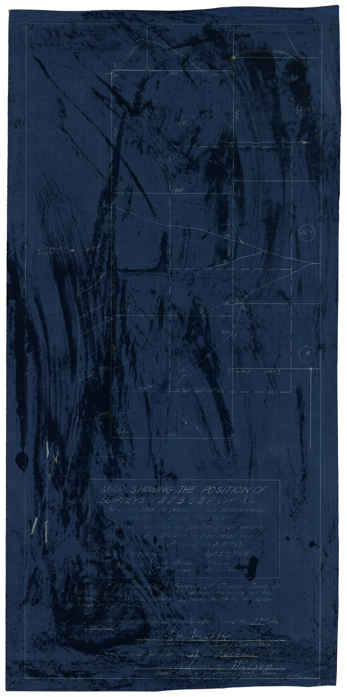
Map Showing the position of surveys 1 & 2, B.S. & F. Cert 1/356
Print $20.00
- Digital $50.00
Map Showing the position of surveys 1 & 2, B.S. & F. Cert 1/356
1915
Size 22.0 x 11.1 inches
Map/Doc 10768
Collingsworth County Working Sketch 3

Print $20.00
- Digital $50.00
Collingsworth County Working Sketch 3
1957
Size 18.9 x 41.5 inches
Map/Doc 68091
Jack County Sketch File 14

Print $8.00
- Digital $50.00
Jack County Sketch File 14
1857
Size 10.0 x 5.7 inches
Map/Doc 27539
Medina County Rolled Sketch 11

Print $20.00
- Digital $50.00
Medina County Rolled Sketch 11
Size 27.4 x 25.6 inches
Map/Doc 6745
Young County Working Sketch 8

Print $20.00
- Digital $50.00
Young County Working Sketch 8
1920
Size 17.3 x 12.6 inches
Map/Doc 62031
United States - Gulf Coast Texas - Southern part of Laguna Madre

Print $20.00
- Digital $50.00
United States - Gulf Coast Texas - Southern part of Laguna Madre
1941
Size 26.7 x 18.3 inches
Map/Doc 72944
Ward County Working Sketch 36

Print $40.00
- Digital $50.00
Ward County Working Sketch 36
1969
Size 49.8 x 48.9 inches
Map/Doc 72342
[Sketch for Mineral Application 33721 - 33725 Incl. - Padre and Mustang Island]
![2870, [Sketch for Mineral Application 33721 - 33725 Incl. - Padre and Mustang Island], General Map Collection](https://historictexasmaps.com/wmedia_w700/maps/2870.tif.jpg)
Print $20.00
- Digital $50.00
[Sketch for Mineral Application 33721 - 33725 Incl. - Padre and Mustang Island]
1942
Size 22.1 x 22.4 inches
Map/Doc 2870