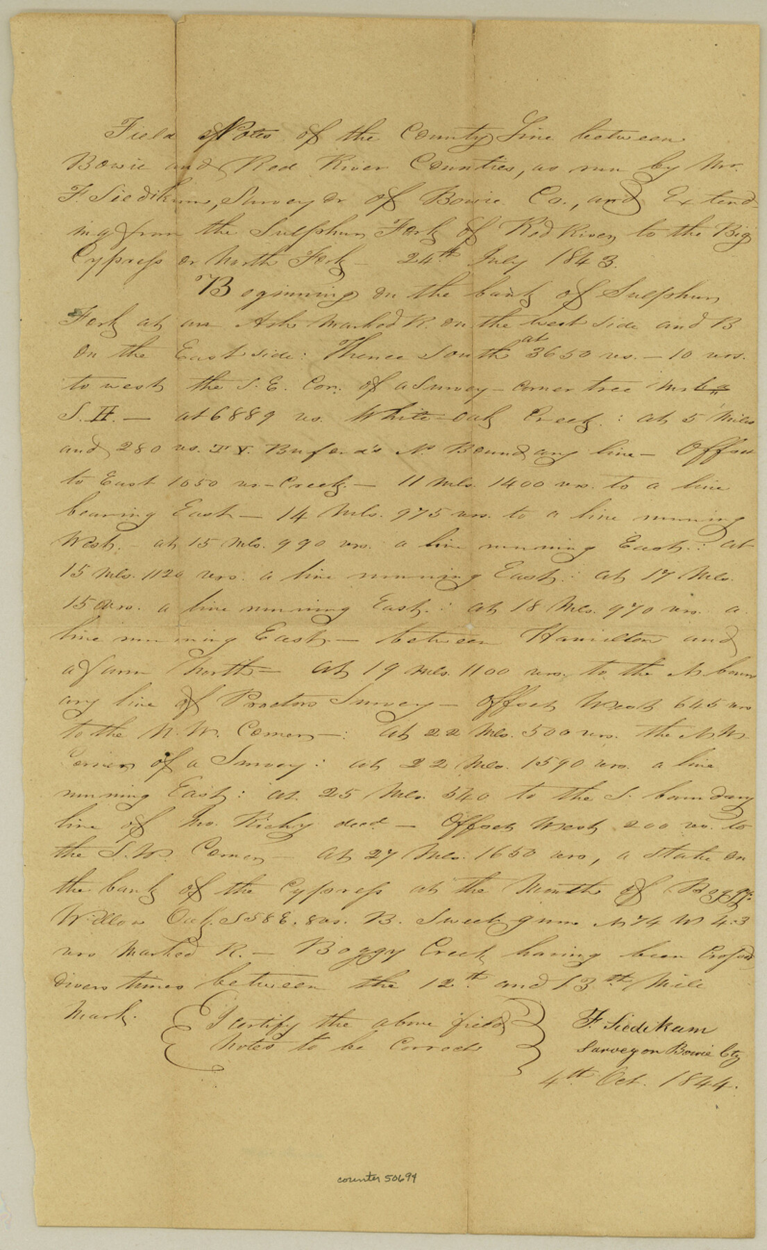
Bowie County Boundary File 72 (23)
Boundary between the Counties of Red River and Bowie
-
Map/Doc
50694
-
Collection
General Map Collection
-
Counties
Bowie
-
Subjects
County Boundaries
-
Height x Width
13.0 x 8.0 inches
33.0 x 20.3 cm
Part of: General Map Collection

Calcasieu Pass to Sabine Pass

Print $20.00
- Digital $50.00
Calcasieu Pass to Sabine Pass
1966
Size 44.9 x 35.5 inches
Map/Doc 69810
Donley County Working Sketch 7

Print $20.00
- Digital $50.00
Donley County Working Sketch 7
1971
Size 23.7 x 26.1 inches
Map/Doc 68740
Wichita County Sketch File 35

Print $8.00
- Digital $50.00
Wichita County Sketch File 35
1950
Size 14.3 x 8.5 inches
Map/Doc 40157
Menard County Sketch File 26

Print $8.00
- Digital $50.00
Menard County Sketch File 26
1936
Size 8.7 x 14.3 inches
Map/Doc 31560
Culberson County Sketch File 4a

Print $10.00
- Digital $50.00
Culberson County Sketch File 4a
Size 9.2 x 7.9 inches
Map/Doc 20131
Gillespie County Sketch File 7a

Print $4.00
- Digital $50.00
Gillespie County Sketch File 7a
Size 3.5 x 8.1 inches
Map/Doc 24143
Newton County Working Sketch 8

Print $20.00
- Digital $50.00
Newton County Working Sketch 8
1937
Size 23.2 x 18.5 inches
Map/Doc 71254
[Sketch for Mineral Application 33721 - 33725 Incl. - Padre and Mustang Island]
![2870, [Sketch for Mineral Application 33721 - 33725 Incl. - Padre and Mustang Island], General Map Collection](https://historictexasmaps.com/wmedia_w700/maps/2870.tif.jpg)
Print $20.00
- Digital $50.00
[Sketch for Mineral Application 33721 - 33725 Incl. - Padre and Mustang Island]
1942
Size 22.1 x 22.4 inches
Map/Doc 2870
Grimes County Working Sketch 6

Print $20.00
- Digital $50.00
Grimes County Working Sketch 6
1951
Size 33.2 x 33.4 inches
Map/Doc 63297
Cameron County NRC Article 33.136 Sketch 4

Print $94.00
- Digital $50.00
Cameron County NRC Article 33.136 Sketch 4
2007
Size 22.3 x 34.0 inches
Map/Doc 88721
Aransas County Working Sketch 9

Print $20.00
- Digital $50.00
Aransas County Working Sketch 9
1947
Size 22.5 x 28.0 inches
Map/Doc 67176
You may also like
Midland County Sketch File D

Print $42.00
- Digital $50.00
Midland County Sketch File D
1901
Size 32.6 x 18.4 inches
Map/Doc 12089
Coast Chart No. 211 - Padre I. and Laguna Madre, Lat. 27° 12' to Lat. 26° 33', Texas

Print $20.00
- Digital $50.00
Coast Chart No. 211 - Padre I. and Laguna Madre, Lat. 27° 12' to Lat. 26° 33', Texas
1890
Size 30.5 x 24.1 inches
Map/Doc 73502
Brewster County Sketch File FN-33

Print $6.00
- Digital $50.00
Brewster County Sketch File FN-33
1975
Size 11.1 x 8.7 inches
Map/Doc 15858
[Surveys in Hopkins and Wood Counties]
![365, [Surveys in Hopkins and Wood Counties], General Map Collection](https://historictexasmaps.com/wmedia_w700/maps/365-1.tif.jpg)
Print $20.00
- Digital $50.00
[Surveys in Hopkins and Wood Counties]
1838
Size 24.7 x 31.7 inches
Map/Doc 365
Sketch showing connections made in survey of the Jerry Barton preemption

Print $20.00
- Digital $50.00
Sketch showing connections made in survey of the Jerry Barton preemption
1892
Size 18.5 x 23.6 inches
Map/Doc 75558
Newton County Rolled Sketch 6A

Digital $50.00
Newton County Rolled Sketch 6A
Size 10.3 x 15.4 inches
Map/Doc 46838
Map No. 1. Eastern States designed to accompany Smith's Geography for School

Print $20.00
- Digital $50.00
Map No. 1. Eastern States designed to accompany Smith's Geography for School
1850
Size 9.8 x 12.1 inches
Map/Doc 93885
Map of City of Brownfield, Texas

Print $20.00
- Digital $50.00
Map of City of Brownfield, Texas
1953
Size 44.4 x 40.1 inches
Map/Doc 89890
[Blocks DT, P, CK, C2, and D7]
![91307, [Blocks DT, P, CK, C2, and D7], Twichell Survey Records](https://historictexasmaps.com/wmedia_w700/maps/91307-1.tif.jpg)
Print $20.00
- Digital $50.00
[Blocks DT, P, CK, C2, and D7]
Size 23.6 x 9.6 inches
Map/Doc 91307
Upton County Sketch File 18

Print $20.00
- Digital $50.00
Upton County Sketch File 18
1927
Size 18.9 x 29.4 inches
Map/Doc 12514
Selected List of Wells accompanying Map of Wyoming showing Test Wells for Oil and Gas, Anticlinal Axes, Oil and Gas Fields, Pipelines, Unit Areas, and Land 3 District Boundaries, 1949

Print $20.00
- Digital $50.00
Selected List of Wells accompanying Map of Wyoming showing Test Wells for Oil and Gas, Anticlinal Axes, Oil and Gas Fields, Pipelines, Unit Areas, and Land 3 District Boundaries, 1949
1949
Size 26.2 x 41.5 inches
Map/Doc 89690
Map of Montgomery County

Print $40.00
- Digital $50.00
Map of Montgomery County
1844
Size 56.6 x 41.3 inches
Map/Doc 78671