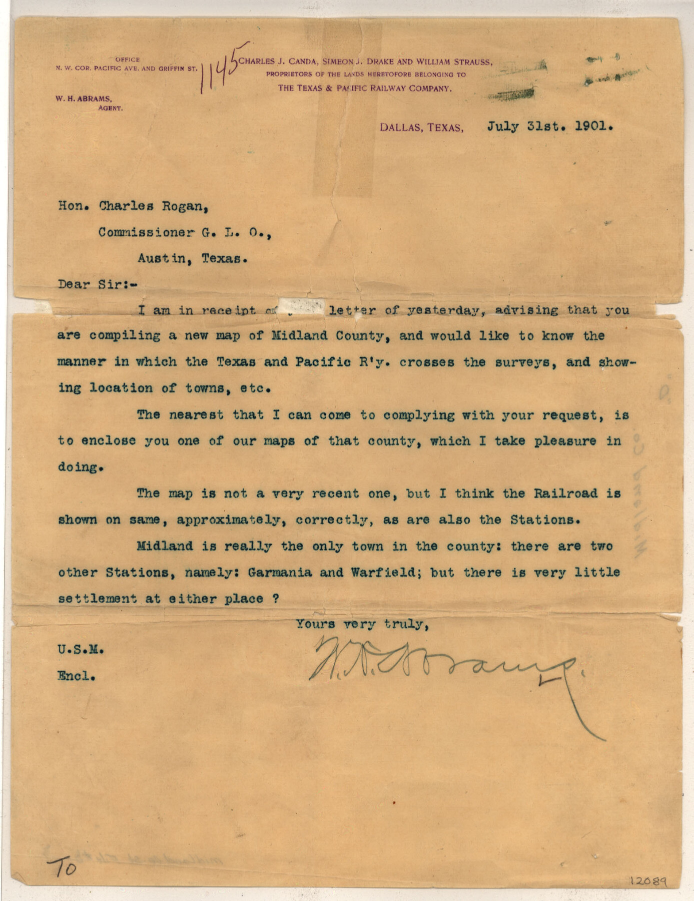
Midland County Sketch File D
Map of Midland County, Texas
-
Map/Doc
12089
-
Collection
General Map Collection
-
Object Dates
7/31/1901 (Creation Date)
7/31/1901 (Correspondence Date)
-
People and Organizations
Dallas Lithograph Co. (Printer)
W.H. Abrams (Surveyor/Engineer)
-
Counties
Midland Martin Andrews Glasscock Upton Ector
-
Subjects
Surveying Sketch File
-
Height x Width
32.6 x 18.4 inches
82.8 x 46.7 cm
-
Medium
multi-page, multi-format
-
Scale
1:4000
-
Features
T&P
Germania
Midland
Warfield
Part of: General Map Collection
Flight Mission No. DQN-2K, Frame 28, Calhoun County

Print $20.00
- Digital $50.00
Flight Mission No. DQN-2K, Frame 28, Calhoun County
1953
Size 18.6 x 22.2 inches
Map/Doc 84235
Lampasas County Boundary File 8

Print $67.00
- Digital $50.00
Lampasas County Boundary File 8
Size 11.0 x 17.0 inches
Map/Doc 56158
Flight Mission No. DCL-7C, Frame 94, Kenedy County

Print $20.00
- Digital $50.00
Flight Mission No. DCL-7C, Frame 94, Kenedy County
1943
Size 15.4 x 15.1 inches
Map/Doc 86066
Montague County Sketch File 22

Print $20.00
- Digital $50.00
Montague County Sketch File 22
1927
Size 27.7 x 20.1 inches
Map/Doc 12107
Uvalde County Sketch File 16a

Print $6.00
- Digital $50.00
Uvalde County Sketch File 16a
Size 11.0 x 13.4 inches
Map/Doc 38995
Crockett County Rolled Sketch 88A

Print $20.00
- Digital $50.00
Crockett County Rolled Sketch 88A
Size 29.9 x 18.6 inches
Map/Doc 5627
Val Verde County Working Sketch 119

Print $40.00
- Digital $50.00
Val Verde County Working Sketch 119
2005
Size 30.5 x 50.0 inches
Map/Doc 83588
Hardin County Rolled Sketch 3

Print $20.00
- Digital $50.00
Hardin County Rolled Sketch 3
1902
Size 20.1 x 17.0 inches
Map/Doc 6076
Schleicher County Working Sketch 3

Print $20.00
- Digital $50.00
Schleicher County Working Sketch 3
1914
Size 23.2 x 17.6 inches
Map/Doc 63805
Partie de l'Amerique Septentrionale, qui Comprend le Canada, la Louisiane, le Labrador, le Groenland, les Etats-Unis et la Floride, &c.

Print $20.00
- Digital $50.00
Partie de l'Amerique Septentrionale, qui Comprend le Canada, la Louisiane, le Labrador, le Groenland, les Etats-Unis et la Floride, &c.
1776
Size 31.2 x 23.4 inches
Map/Doc 95140
Flight Mission No. CGI-4N, Frame 20, Cameron County

Print $20.00
- Digital $50.00
Flight Mission No. CGI-4N, Frame 20, Cameron County
1954
Size 18.6 x 22.3 inches
Map/Doc 84653
Corpus Christi Bay, Texas

Print $40.00
- Digital $50.00
Corpus Christi Bay, Texas
1867
Size 32.3 x 49.0 inches
Map/Doc 73469
You may also like
Jefferson County Sketch File 12

Print $63.00
- Digital $50.00
Jefferson County Sketch File 12
Size 8.8 x 7.5 inches
Map/Doc 28135
[Surveys along the Bosque River]
![236, [Surveys along the Bosque River], General Map Collection](https://historictexasmaps.com/wmedia_w700/maps/236.tif.jpg)
Print $3.00
- Digital $50.00
[Surveys along the Bosque River]
1846
Size 9.4 x 12.8 inches
Map/Doc 236
Sutton County Rolled Sketch H

Print $40.00
- Digital $50.00
Sutton County Rolled Sketch H
Size 24.9 x 50.0 inches
Map/Doc 9973

Denton County Boundary File 1a

Print $24.00
- Digital $50.00
Denton County Boundary File 1a
Size 12.4 x 8.1 inches
Map/Doc 52401
Gaines County Working Sketch 8

Print $20.00
- Digital $50.00
Gaines County Working Sketch 8
1951
Size 21.8 x 24.8 inches
Map/Doc 69308
King County Sketch File 10

Print $24.00
- Digital $50.00
King County Sketch File 10
1902
Size 14.2 x 8.7 inches
Map/Doc 29083
The Coast & Bays of Western Texas, St. Joseph's and Mustang Islands from actual survey, the remainder from county maps, etc.

Print $20.00
- Digital $50.00
The Coast & Bays of Western Texas, St. Joseph's and Mustang Islands from actual survey, the remainder from county maps, etc.
1857
Size 28.0 x 18.3 inches
Map/Doc 72767
Kleberg County Sketch File 1

Print $36.00
- Digital $50.00
Kleberg County Sketch File 1
1994
Size 8.8 x 11.3 inches
Map/Doc 29192
Gonzales County Sketch File 6

Print $4.00
- Digital $50.00
Gonzales County Sketch File 6
1880
Size 10.2 x 8.7 inches
Map/Doc 24385
Hutchinson County Working Sketch 49

Print $20.00
- Digital $50.00
Hutchinson County Working Sketch 49
1988
Size 35.2 x 37.3 inches
Map/Doc 66409
Gaines County Rolled Sketch G3

Print $20.00
- Digital $50.00
Gaines County Rolled Sketch G3
1902
Size 22.7 x 31.4 inches
Map/Doc 5946