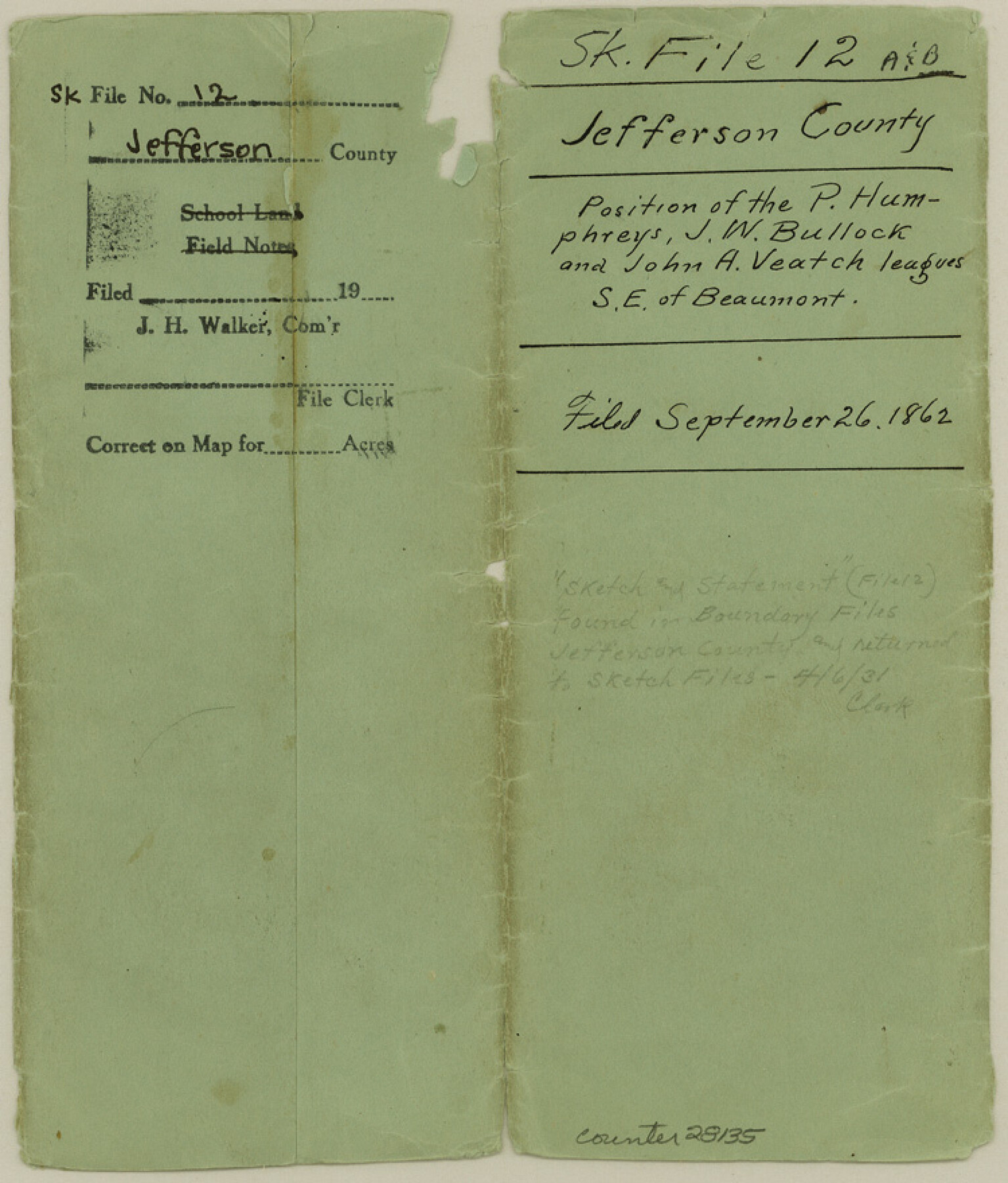
Jefferson County Sketch File 12
[Position of the P. Humphreys, J. W. Bullock, and John A. Veatch leagues, southeast of Beaumont]
-
Map/Doc
28135
-
Collection
General Map Collection
-
Object Dates
9/26/1862 (File Date)
8/9/1862 (File Date)
10/7/1862 (Correspondence Date)
9/21/1862 (Correspondence Date)
9/24/1927 (Correspondence Date)
-
People and Organizations
James Ingalls (Surveyor/Engineer)
B.F. Marsh (Surveyor/Engineer)
-
Counties
Jefferson
-
Subjects
Surveying Sketch File
-
Height x Width
8.8 x 7.5 inches
22.4 x 19.1 cm
-
Medium
multi-page, multi-format
-
Features
Sabine Lake
Sabine Pass Depot
Beaumont
Taylors Bayou
Naches [sic] [River] Marsh
Chamber's Bluff
ETR
Rhodair [Station]
Part of: General Map Collection
Kendall County Working Sketch 17

Print $20.00
- Digital $50.00
Kendall County Working Sketch 17
1968
Size 31.0 x 30.9 inches
Map/Doc 66689
Webb County Sketch File 5-1

Print $4.00
- Digital $50.00
Webb County Sketch File 5-1
Size 3.7 x 12.6 inches
Map/Doc 39733
Moore County Rolled Sketch 11

Print $20.00
- Digital $50.00
Moore County Rolled Sketch 11
Size 34.1 x 43.0 inches
Map/Doc 9549
Mills County Working Sketch 9

Print $20.00
- Digital $50.00
Mills County Working Sketch 9
1915
Size 13.3 x 13.7 inches
Map/Doc 71039
Hays County Working Sketch 12

Print $20.00
- Digital $50.00
Hays County Working Sketch 12
1950
Size 22.8 x 24.3 inches
Map/Doc 66086
Clay County Sketch File 27

Print $20.00
- Digital $50.00
Clay County Sketch File 27
1900
Size 18.8 x 16.5 inches
Map/Doc 11089
Brewster County Sketch File 57

Print $6.00
- Digital $50.00
Brewster County Sketch File 57
2008
Size 11.0 x 8.5 inches
Map/Doc 88871
Mason County Sketch File 21

Print $6.00
- Digital $50.00
Mason County Sketch File 21
Size 15.7 x 10.9 inches
Map/Doc 30717
Comanche County Sketch File 20a

Print $2.00
- Digital $50.00
Comanche County Sketch File 20a
Size 12.9 x 8.2 inches
Map/Doc 19105
Texas Intracoastal Waterway - Laguna Madre - Dagger Hill to Potrero Grande

Print $20.00
- Digital $50.00
Texas Intracoastal Waterway - Laguna Madre - Dagger Hill to Potrero Grande
1960
Size 38.3 x 27.0 inches
Map/Doc 73511
Edwards County Sketch File 21

Print $6.00
- Digital $50.00
Edwards County Sketch File 21
1889
Size 12.9 x 8.5 inches
Map/Doc 21740
Boundary between State of Texas and State of Louisiana from the 32nd Parallel South into the Gulf of Mexico

Print $326.00
Boundary between State of Texas and State of Louisiana from the 32nd Parallel South into the Gulf of Mexico
1977
Size 11.1 x 8.0 inches
Map/Doc 7710
You may also like
Wilbarger County Working Sketch 10

Print $20.00
- Digital $50.00
Wilbarger County Working Sketch 10
1951
Size 23.5 x 32.3 inches
Map/Doc 72548
Tech Memorial Park, Inc. Section Q

Print $20.00
- Digital $50.00
Tech Memorial Park, Inc. Section Q
Size 34.8 x 21.2 inches
Map/Doc 92357
Lampasas County Working Sketch 20

Print $20.00
- Digital $50.00
Lampasas County Working Sketch 20
1981
Size 26.0 x 31.9 inches
Map/Doc 70297
Map of Haskell County Young District

Print $20.00
- Digital $50.00
Map of Haskell County Young District
1859
Size 21.9 x 25.8 inches
Map/Doc 3641
Starr County Sketch File 50

Print $40.00
- Digital $50.00
Starr County Sketch File 50
1963
Size 12.4 x 15.5 inches
Map/Doc 37007
Jack County Working Sketch 13

Print $20.00
- Digital $50.00
Jack County Working Sketch 13
1975
Size 25.5 x 35.8 inches
Map/Doc 66439
Flight Mission No. BRA-7M, Frame 81, Jefferson County

Print $20.00
- Digital $50.00
Flight Mission No. BRA-7M, Frame 81, Jefferson County
1953
Size 16.0 x 15.8 inches
Map/Doc 85503
Hopkins County Sketch File 17

Print $6.00
- Digital $50.00
Hopkins County Sketch File 17
1870
Size 7.8 x 8.0 inches
Map/Doc 26720
Cochran County Sketch File 7

Print $10.00
- Digital $50.00
Cochran County Sketch File 7
1940
Size 11.2 x 8.6 inches
Map/Doc 18550
Right-of-Way & Track Map, Houston and Brazos Valley Ry. Co. operated by the Houston and Brazos Valley Ry. Co.

Print $40.00
- Digital $50.00
Right-of-Way & Track Map, Houston and Brazos Valley Ry. Co. operated by the Houston and Brazos Valley Ry. Co.
1918
Size 25.0 x 55.7 inches
Map/Doc 64605
![88951, Haskell Co[unty], Library of Congress](https://historictexasmaps.com/wmedia_w700/maps/88951.tif.jpg)
Boundary Between the United States & Mexico Agreed Upon by the Joint Commission under the Treaty of Guadalupe Hidalgo

Print $20.00
- Digital $50.00
Boundary Between the United States & Mexico Agreed Upon by the Joint Commission under the Treaty of Guadalupe Hidalgo
1853
Size 24.2 x 18.4 inches
Map/Doc 65397