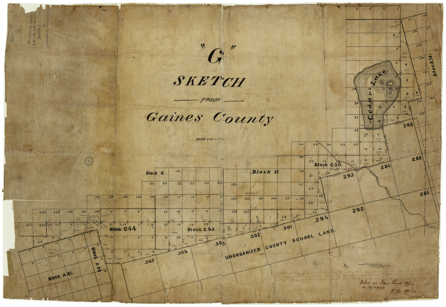
Gaines County Rolled Sketch G3
"G" sketch from Gaines County [showing surveys NW of unorganized county school land]
-
Map/Doc
5946
-
Collection
General Map Collection
-
Object Dates
3/29/1902 (Creation Date)
6/3/1902 (File Date)
-
People and Organizations
W.D. Twichell (Surveyor/Engineer)
-
Counties
Gaines
-
Subjects
Surveying Rolled Sketch
-
Height x Width
22.7 x 31.4 inches
57.7 x 79.8 cm
-
Medium
paper, manuscript
Part of: General Map Collection
Baylor County Sketch File A9

Print $8.00
- Digital $50.00
Baylor County Sketch File A9
1926
Size 11.4 x 8.9 inches
Map/Doc 14096
Ector County Working Sketch 4

Print $20.00
- Digital $50.00
Ector County Working Sketch 4
1940
Size 25.8 x 30.0 inches
Map/Doc 68847
Nueces County Aerial Photograph Index Sheet 5

Print $20.00
- Digital $50.00
Nueces County Aerial Photograph Index Sheet 5
1956
Size 19.5 x 23.4 inches
Map/Doc 83738
Victoria County Working Sketch 2

Print $20.00
- Digital $50.00
Victoria County Working Sketch 2
1939
Size 43.1 x 28.1 inches
Map/Doc 72272
Leon County Working Sketch 33

Print $20.00
- Digital $50.00
Leon County Working Sketch 33
1978
Size 43.4 x 41.6 inches
Map/Doc 70432

Cooke County Sketch File 6

Print $8.00
- Digital $50.00
Cooke County Sketch File 6
1857
Size 11.0 x 8.4 inches
Map/Doc 19228
Dallam County

Print $20.00
- Digital $50.00
Dallam County
1901
Size 43.8 x 29.3 inches
Map/Doc 93458
Calhoun County Rolled Sketch 29C

Print $20.00
- Digital $50.00
Calhoun County Rolled Sketch 29C
1977
Size 22.0 x 24.0 inches
Map/Doc 8559
El Paso County Working Sketch 4

Print $20.00
- Digital $50.00
El Paso County Working Sketch 4
1916
Size 21.4 x 37.3 inches
Map/Doc 69026
Hardin County Working Sketch 41

Print $20.00
- Digital $50.00
Hardin County Working Sketch 41
Size 35.1 x 40.0 inches
Map/Doc 63440
Real County Working Sketch 63

Print $20.00
- Digital $50.00
Real County Working Sketch 63
1967
Size 28.8 x 32.3 inches
Map/Doc 71955
You may also like
Angelina County Working Sketch 21

Print $20.00
- Digital $50.00
Angelina County Working Sketch 21
1947
Size 35.7 x 35.8 inches
Map/Doc 67102
La Salle County Rolled Sketch 28

Print $90.00
- Digital $50.00
La Salle County Rolled Sketch 28
1956
Size 51.1 x 49.1 inches
Map/Doc 9561
Motley County Sketch File DD (S)

Print $22.00
- Digital $50.00
Motley County Sketch File DD (S)
Size 10.9 x 7.1 inches
Map/Doc 32159
Flight Mission No. CGN-3P, Frame 21, San Patricio County

Print $20.00
- Digital $50.00
Flight Mission No. CGN-3P, Frame 21, San Patricio County
1956
Size 18.2 x 22.0 inches
Map/Doc 86979
Carter Estate, North Half 77, Block A, Lubbock County

Print $20.00
- Digital $50.00
Carter Estate, North Half 77, Block A, Lubbock County
1941
Size 9.8 x 18.4 inches
Map/Doc 92751
Mitchell Estate Subdivision

Print $20.00
- Digital $50.00
Mitchell Estate Subdivision
1953
Size 9.3 x 19.8 inches
Map/Doc 92505
Dickens County Sketch File E

Print $8.00
- Digital $50.00
Dickens County Sketch File E
Size 11.3 x 8.7 inches
Map/Doc 20843
Flight Mission No. BQR-16K, Frame 34, Brazoria County

Print $20.00
- Digital $50.00
Flight Mission No. BQR-16K, Frame 34, Brazoria County
1952
Size 18.7 x 22.4 inches
Map/Doc 84101
Milam County Sketch File 3

Print $4.00
- Digital $50.00
Milam County Sketch File 3
1853
Size 12.9 x 8.1 inches
Map/Doc 31628
Texas Intracoastal Waterway - Port O'Connor to San Antonio Bay, Including Pass Cavallo

Print $20.00
- Digital $50.00
Texas Intracoastal Waterway - Port O'Connor to San Antonio Bay, Including Pass Cavallo
1961
Size 26.5 x 38.7 inches
Map/Doc 73373
[Sketch of Surveys in Cottle, Dickens, King & Motley Counties, Texas]
![75830, [Sketch of Surveys in Cottle, Dickens, King & Motley Counties, Texas], Maddox Collection](https://historictexasmaps.com/wmedia_w700/maps/75830.tif.jpg)
Print $20.00
- Digital $50.00
[Sketch of Surveys in Cottle, Dickens, King & Motley Counties, Texas]
1913
Size 29.6 x 23.2 inches
Map/Doc 75830
Map of Midland County

Print $20.00
- Digital $50.00
Map of Midland County
1901
Size 43.9 x 38.3 inches
Map/Doc 7825