Texas Intracoastal Waterway - Port O'Connor to San Antonio Bay, Including Pass Cavallo
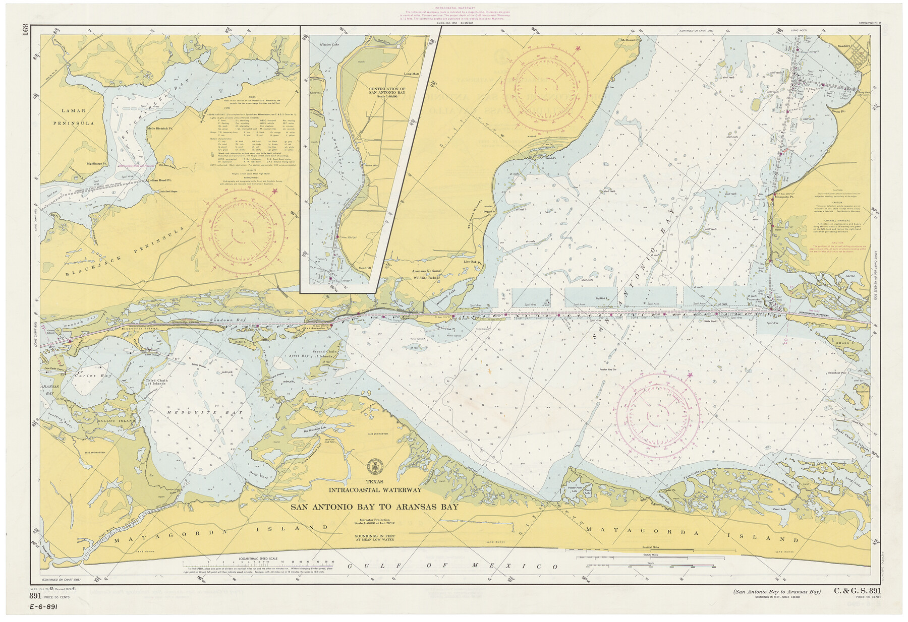
Texas Intracoastal Waterway - San Antonio Bay to Aransas Bay
K-6-890a; K.6.891a
-
Map/Doc
73373
-
Collection
General Map Collection
-
Object Dates
10/9/1961 (Creation Date)
-
Counties
Refugio Calhoun Aransas
-
Subjects
Nautical Charts
-
Height x Width
26.5 x 38.7 inches
67.3 x 98.3 cm
-
Comments
dual-sided map
Part of: General Map Collection
Map of Brazoria

Print $20.00
- Digital $50.00
Map of Brazoria
1860
Size 18.2 x 23.6 inches
Map/Doc 4509
Cameron County Aerial Photograph Index Sheet 6

Print $20.00
- Digital $50.00
Cameron County Aerial Photograph Index Sheet 6
1940
Size 20.3 x 24.3 inches
Map/Doc 83682
Map of The Surveyed Part of Peters Colony Texas

Print $40.00
- Digital $50.00
Map of The Surveyed Part of Peters Colony Texas
1858
Size 45.0 x 58.1 inches
Map/Doc 4653
Brewster County Working Sketch 85

Print $20.00
- Digital $50.00
Brewster County Working Sketch 85
1973
Size 43.2 x 34.0 inches
Map/Doc 67685
Gillespie County Working Sketch 10

Print $20.00
- Digital $50.00
Gillespie County Working Sketch 10
1994
Size 45.0 x 35.1 inches
Map/Doc 63173

Kenedy County Aerial Photograph Index Sheet 1

Print $20.00
- Digital $50.00
Kenedy County Aerial Photograph Index Sheet 1
1943
Size 23.3 x 19.5 inches
Map/Doc 83713
El Paso County Working Sketch 15

Print $40.00
- Digital $50.00
El Paso County Working Sketch 15
1957
Size 23.3 x 127.5 inches
Map/Doc 69037
Brewster County Sketch File D-1

Print $12.00
- Digital $50.00
Brewster County Sketch File D-1
1909
Size 14.4 x 8.8 inches
Map/Doc 15740
McLennan County Working Sketch 9

Print $20.00
- Digital $50.00
McLennan County Working Sketch 9
2008
Size 23.0 x 28.9 inches
Map/Doc 88768

Newton County Sketch File 42

Print $39.00
- Digital $50.00
Newton County Sketch File 42
1936
Size 13.2 x 8.7 inches
Map/Doc 32425
You may also like
Brewster County Rolled Sketch 22D

Print $20.00
- Digital $50.00
Brewster County Rolled Sketch 22D
1910
Size 32.3 x 24.9 inches
Map/Doc 5205
Hansford County Sketch File 1

Print $7.00
- Digital $50.00
Hansford County Sketch File 1
1888
Size 39.0 x 31.3 inches
Map/Doc 10475
Hutchinson County Sketch File 53

Print $2.00
- Digital $50.00
Hutchinson County Sketch File 53
2000
Size 11.2 x 8.8 inches
Map/Doc 27455
Topographical Map of the Rio Grande, Sheet No. 4

Print $20.00
- Digital $50.00
Topographical Map of the Rio Grande, Sheet No. 4
1912
Map/Doc 89528
Travis County Working Sketch 41

Print $20.00
- Digital $50.00
Travis County Working Sketch 41
1974
Size 34.4 x 31.3 inches
Map/Doc 69425
[Isaac Scott and J. Walker surveys and vicinity]
![92664, [Isaac Scott and J. Walker surveys and vicinity], Twichell Survey Records](https://historictexasmaps.com/wmedia_w700/maps/92664-1.tif.jpg)
Print $40.00
- Digital $50.00
[Isaac Scott and J. Walker surveys and vicinity]
Size 54.0 x 29.1 inches
Map/Doc 92664
Roberts County Boundary File 2c

Print $28.00
- Digital $50.00
Roberts County Boundary File 2c
Size 9.5 x 28.3 inches
Map/Doc 58363
Lubbock County Boundary File 5

Print $2.00
- Digital $50.00
Lubbock County Boundary File 5
Size 7.2 x 8.2 inches
Map/Doc 56493
General Highway Map, Lampasas County, Texas

Print $20.00
General Highway Map, Lampasas County, Texas
1961
Size 18.2 x 24.7 inches
Map/Doc 79563
Flight Mission No. DCL-4C, Frame 67, Kenedy County

Print $20.00
- Digital $50.00
Flight Mission No. DCL-4C, Frame 67, Kenedy County
1943
Size 18.7 x 22.3 inches
Map/Doc 85812
Road Guide of Central Texas, Colorado River, Highland Lakes and Hill Country

Print $20.00
- Digital $50.00
Road Guide of Central Texas, Colorado River, Highland Lakes and Hill Country
1947
Size 18.0 x 21.7 inches
Map/Doc 60293
Coke County Boundary File 5

Print $36.00
- Digital $50.00
Coke County Boundary File 5
Size 7.7 x 37.9 inches
Map/Doc 51606