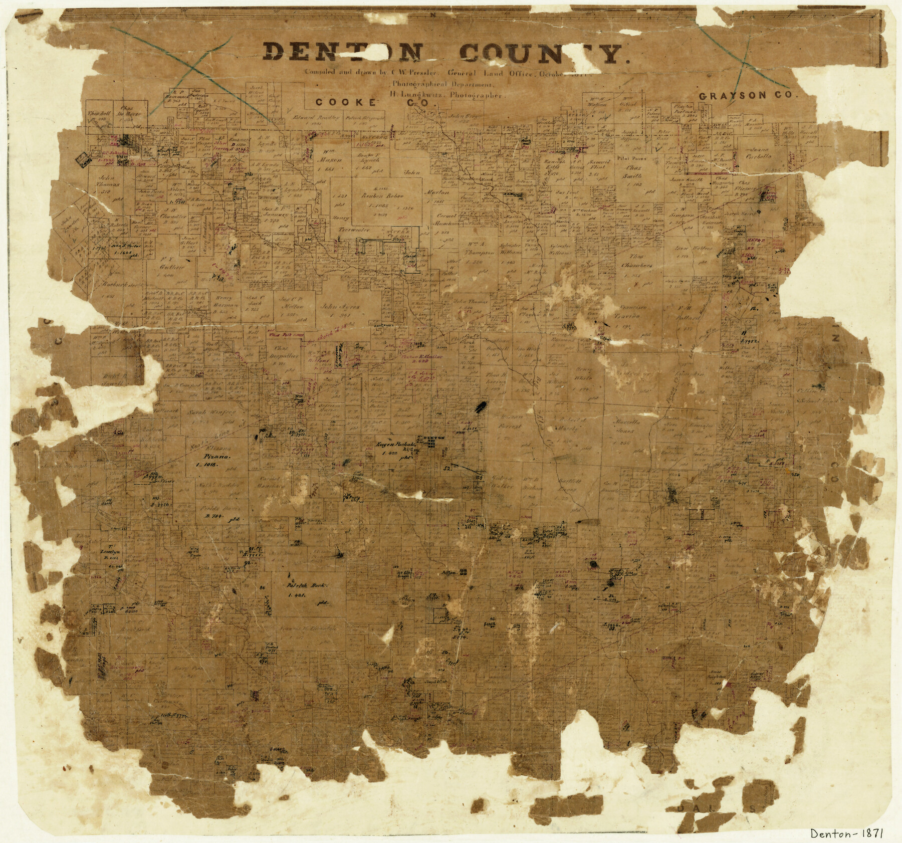
Denton County
-
Map/Doc
4531
-
Collection
General Map Collection
-
Object Dates
10/1871 (Creation Date)
-
People and Organizations
Herman Lungkwitz (Draftsman)
Chas. W. Pressler (Draftsman)
-
Counties
Denton
-
Subjects
County
-
Height x Width
18.4 x 19.6 inches
46.7 x 49.8 cm
-
Features
South Fork of Hickory Creek
Pilot Point
Stewarts Creek
Alton
Panther Creek
Pecan Creek
Little Elm Creek
Big Elm Creek
Denton
Hickory Creek
Fannin's Creek
North Fork of Hickory Creek
Clear Creek
Mustang Creek
Isle du Bois Creek
Pond Creek
Spring Creek
Duck Creek
Dry Fork of Hickory Creek
Part of: General Map Collection
Houston County Sketch File 37

Print $6.00
- Digital $50.00
Houston County Sketch File 37
1846
Size 12.8 x 7.8 inches
Map/Doc 26819
Sketch Showing Property Lines of Harlem State Farm

Print $20.00
- Digital $50.00
Sketch Showing Property Lines of Harlem State Farm
Size 16.0 x 30.2 inches
Map/Doc 62982
Maps of Gulf Intracoastal Waterway, Texas - Sabine River to the Rio Grande and connecting waterways including ship channels

Print $20.00
- Digital $50.00
Maps of Gulf Intracoastal Waterway, Texas - Sabine River to the Rio Grande and connecting waterways including ship channels
1966
Size 14.5 x 22.4 inches
Map/Doc 61951
Harris County Rolled Sketch 96A

Print $20.00
- Digital $50.00
Harris County Rolled Sketch 96A
Size 45.7 x 37.7 inches
Map/Doc 9143
Coryell County Working Sketch 12

Print $20.00
- Digital $50.00
Coryell County Working Sketch 12
1949
Size 36.0 x 38.7 inches
Map/Doc 68219
Flight Mission No. BRA-7M, Frame 81, Jefferson County

Print $20.00
- Digital $50.00
Flight Mission No. BRA-7M, Frame 81, Jefferson County
1953
Size 16.0 x 15.8 inches
Map/Doc 85503
Louisiana and Texas Intracoastal Waterway - Matagorda Bay to San Antonio Bay Dredging - Sheet 1

Print $20.00
- Digital $50.00
Louisiana and Texas Intracoastal Waterway - Matagorda Bay to San Antonio Bay Dredging - Sheet 1
1938
Size 31.1 x 41.3 inches
Map/Doc 61814
Nueces County Rolled Sketch 79

Print $20.00
- Digital $50.00
Nueces County Rolled Sketch 79
1894
Size 38.1 x 31.3 inches
Map/Doc 9627
Rockport Quadrangle

Print $20.00
- Digital $50.00
Rockport Quadrangle
1954
Size 21.3 x 18.3 inches
Map/Doc 73435
Colorado River, Twin Basin Sheet

Print $6.00
- Digital $50.00
Colorado River, Twin Basin Sheet
1941
Size 27.2 x 35.1 inches
Map/Doc 65317
Travis County Appraisal District Plat Map 2_0805

Print $20.00
- Digital $50.00
Travis County Appraisal District Plat Map 2_0805
Size 21.4 x 26.4 inches
Map/Doc 94231
Franklin County Sketch File 9

Print $20.00
- Digital $50.00
Franklin County Sketch File 9
Size 13.6 x 23.1 inches
Map/Doc 11515
You may also like
Brewster County Rolled Sketch A

Print $40.00
- Digital $50.00
Brewster County Rolled Sketch A
Size 26.7 x 94.8 inches
Map/Doc 8925
[Blocks D3 and GP]
![91506, [Blocks D3 and GP], Twichell Survey Records](https://historictexasmaps.com/wmedia_w700/maps/91506-1.tif.jpg)
Print $20.00
- Digital $50.00
[Blocks D3 and GP]
Size 18.2 x 19.3 inches
Map/Doc 91506
Swisher County Working Sketch 4

Print $20.00
- Digital $50.00
Swisher County Working Sketch 4
1960
Size 23.0 x 19.9 inches
Map/Doc 62415
Hood County Sketch File 4

Print $4.00
- Digital $50.00
Hood County Sketch File 4
Size 8.8 x 7.8 inches
Map/Doc 26575
Ward County Rolled Sketch 24C

Print $40.00
- Digital $50.00
Ward County Rolled Sketch 24C
1967
Size 54.8 x 24.4 inches
Map/Doc 10114
Map of Harris District

Print $20.00
- Digital $50.00
Map of Harris District
1847
Size 25.4 x 34.4 inches
Map/Doc 1680
Hardin County Working Sketch 10

Print $20.00
- Digital $50.00
Hardin County Working Sketch 10
1929
Size 24.0 x 25.3 inches
Map/Doc 63408
Floyd County Sketch File 1

Print $5.00
- Digital $50.00
Floyd County Sketch File 1
Size 11.0 x 17.0 inches
Map/Doc 22688
Childress County Working Sketch 5

Print $20.00
- Digital $50.00
Childress County Working Sketch 5
1948
Size 19.6 x 23.5 inches
Map/Doc 68021
Robertson County Working Sketch 11

Print $20.00
- Digital $50.00
Robertson County Working Sketch 11
1984
Size 20.2 x 21.4 inches
Map/Doc 63584
Flight Mission No. CRC-5R, Frame 17, Chambers County

Print $20.00
- Digital $50.00
Flight Mission No. CRC-5R, Frame 17, Chambers County
1956
Size 18.8 x 22.5 inches
Map/Doc 84939
Lynn County Rolled Sketch S

Print $20.00
- Digital $50.00
Lynn County Rolled Sketch S
Size 21.1 x 38.7 inches
Map/Doc 6654